Upper Ganges Canal
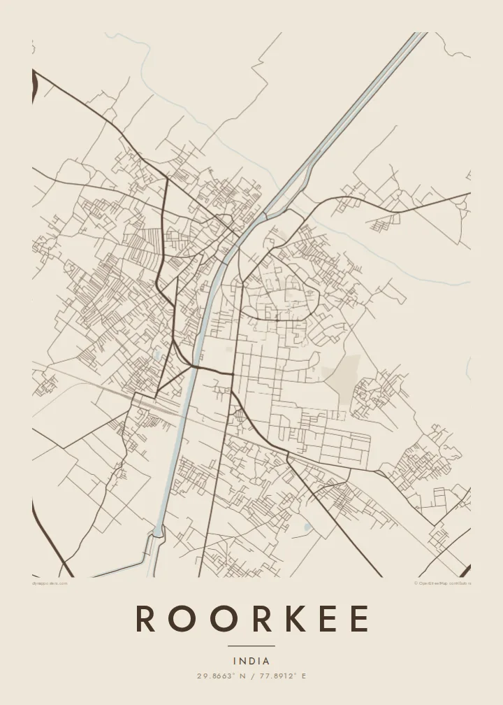
The canal runs through Roorkee in a nearly straight line, crossed by several bridges, and is the clearest, most recognisable feature of the poster.
Qeeqabak kaartah poster · India
29.8663° N / 77.8912° E
A canal town where the Upper Ganges Canal runs straight through the centre, beside the broad campus of IIT Roorkee.


Inki magaala, konoy gaba
Qande inkih tibbixeeh derre baguley table. Kulli qande missoowa caagid—daabbisimta, dirbaabu-le kaadu HD fayla akah.
 Cagalah pixels · 24 × 36″ daabbi fayla
Maxxaacah qeeqa
Tama usuk cagalah daabbi faylak 100% qambaala. Kulli poster — daabbisimta, dirbaabu-le kaadu download geytimta — ni-server-ittal 300 DPI-l ederimta, 7,200 × 10,800 pixels fanah, tokkel iyyi ellee catoy 24 × 36″ daabbi baxsi bahisak raaqu.
Gidarih


Kaarta
Roorkee, in the Haridwar district of Uttarakhand, is a town defined by water engineering. The Upper Ganges Canal, opened in 1854, passes directly through it on a long, straight course, and much of the town was organised around the works that built and maintained it. On the map the canal is the dominant line, with bridges crossing it and streets on both banks.
The engineering college founded here in 1847 to train staff for the canal project later became the Indian Institute of Technology Roorkee, one of the oldest technical institutions in Asia. Its campus takes up a large, green part of the town, with wide roads and open grounds. Roorkee also has a long-established army cantonment, whose orderly layout contrasts with the denser market streets.
A Roorkee map poster suits anyone who has studied, taught or served here. The straight canal, the spacious campus, the measured roads of the cantonment and the older bazaar areas each have their own texture, and together they tell a clear story. Just outside town the canal crosses the Solani River on a well-known aqueduct, a detail worth including in the frame.
The canal runs through Roorkee in a nearly straight line, crossed by several bridges, and is the clearest, most recognisable feature of the poster.
The institute's grounds take up a large block of the town, with generous roads, playing fields and buildings set in open space.
Near the town, a long nineteenth-century aqueduct carries the canal over the Solani River, so on the map water crosses water.
Kok tanim ab
Ayro, migaq hinnay kok tan xagar osis; gaba, ballaqa hinnay xiqa soorris.
Free preview qansarissi kee watermark-le. Daabbisimtaan kee HD fayla 300 DPI-l, 7,200 × 10,800 px fanah, watermark maleh ederimta.
Macah Roorkee
Few towns are so closely tied to a single campus. For IIT Roorkee alumni, a map of the canal banks and hostels is a direct link to formative years. Put your batch year in the subtitle, name your hostel in the title, or set the coordinates to your department.
Choose Classic black & white, Noir, Paper, Blueprint or Sand. The $9 download includes six print sizes as 300 DPI PNGs and print-ready PDFs with no watermark, and a free 900 px preview lets you check the framing first. Matte prints, with an optional wooden frame, ship from partners in 30+ countries.
Roorkee poster orme| Maxxaacah ballaqa | Qeeqa | Faylal |
|---|---|---|
| 30 × 40 cm (11.8 × 15.7″) | 3,543 × 4,724 px | PNG · PDF |
| 29.7 × 42 cm (A3, 11.7 × 16.5″) | 3,508 × 4,961 px | PNG · PDF |
| 42 × 59.4 cm (A2, 16.5 × 23.4″) | 4,961 × 7,016 px | PNG · PDF |
| 45.7 × 61 cm (18 × 24″) | 5,400 × 7,200 px | PNG · PDF |
| 50 × 70 cm (19.7 × 27.6″) | 5,906 × 8,268 px | PNG · PDF |
| 61 × 91.4 cm (24 × 36″) | 7,200 × 10,800 px | PNG · PDF |
Tabbaltah, limo-wayta xaqqa-le ablo 900 px ballaqa le, asta le, iskiriinih keh tan. HD faylal gexsoh inkih addal 8× fanah qeeqa le, poster ballaqa inkih addal meqeh maxxaacimta.
Baxxaqqa qari le qandiy dooriy, tohuk lakal Daabbisimtah Poster — kutuk kee, faxximek, dirbaabu — hinnay HD Digital Fayla dooru. Checkout inki wagitti geytima, kaadu ku-orme page keenih adissa akke waqdi caagoy kummite.
Usuk 200 gsm-le catam kutuk warqatal, lica katiy caagitte $39-ik hane ayta 30 × 40 cm-ik 24 × 36″ fanah, xaagu keenil warreeh.
Ee. Sarrah-le dirbaabu doori — bad, gudduc, oak-le hinnay bad-madabuy. Usuk finqisiimam ellee sange qarab-le kaadu qari umukku iyya keenih taagu. Dirbaabu-le poster $99-ik hane, xaagu keenil warreeh.
Shipping is free worldwide. Each poster is printed by the nearest of our print partners in 30+ countries and usually arrives in 3–7 business days. You can follow the status and tracking under My Orders. A few countries take 2–5 weeks, and where we don't ship yet, the site tells you before you pay.
Geytimeek 14 ayróy addal foto naah rubbaay, cisab-le daabbisiynah hinnay ku-lacay gacisnaah.
Ee. Tama page-l edito addal, migaaq, subtitle kee coordinates sarrah faxxem fanah badal, kaadu qande kee katiy doori. Daabbisimtah, dirbaabu-le kaadu digital orme inkih ku-design cagalah yekkelen.
$9 bacisak 300 DPI PNG kee daabbisimtah adissime PDF fayla lica katiy inkih, watermark maleh, ayyi meki daabbisimtah geeytitta. Cisab makkoysemty ana? Awqak, watermark-le free preview download-eh.
