Ria coastline
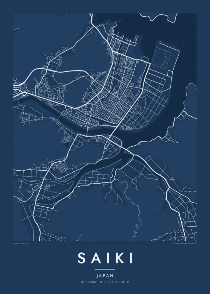
Drowned valleys form a shoreline of fingers and bays, one of the most intricate coastal outlines a map can show.
Qeeqabak kaartah poster · Japan
32.9500° N / 131.9000° E
A deeply indented ria coast of inlets, peninsulas and islands, with a castle hill above a river-mouth town.



Inki magaala, konoy gaba
Qande inkih tibbixeeh derre baguley table. Kulli qande missoowa caagid—daabbisimta, dirbaabu-le kaadu HD fayla akah.
 Cagalah pixels · 24 × 36″ daabbi fayla
Maxxaacah qeeqa
Tama usuk cagalah daabbi faylak 100% qambaala. Kulli poster — daabbisimta, dirbaabu-le kaadu download geytimta — ni-server-ittal 300 DPI-l ederimta, 7,200 × 10,800 pixels fanah, tokkel iyyi ellee catoy 24 × 36″ daabbi baxsi bahisak raaqu.
Gidarih


Kaarta
Saiki occupies the southeastern corner of Oita Prefecture, where the Kyushu coast breaks up into a ria shoreline of drowned valleys. On a map the coast is anything but straight: narrow inlets reach far inland, long peninsulas point out toward the Bungo Channel and small islands sit offshore.
The city centre lies on low ground near the mouth of the Banjo River. Above it rises Shiroyama, a wooded hill that once held Saiki Castle; today its stone walls remain, reached by paths through the trees. The streets of the old castle town spread across the flat land at its foot.
Following municipal mergers, Saiki became one of the largest municipalities in Kyushu by area, covering mountain valleys as well as the coast. Fishing villages sit at the heads of many inlets, and the city is well known for its seafood. A Saiki map poster shows that coastline in all its detail, with a small castle town in the middle.
Drowned valleys form a shoreline of fingers and bays, one of the most intricate coastal outlines a map can show.
Shiroyama rises directly behind the town centre, a rounded patch of green with the former castle town's streets gathered below.
The river widens as it reaches the sea near the centre, dividing the low ground and linking the town to the harbour.
Kok tanim ab
Ayro, migaq hinnay kok tan xagar osis; gaba, ballaqa hinnay xiqa soorris.
Free preview qansarissi kee watermark-le. Daabbisimtaan kee HD fayla 300 DPI-l, 7,200 × 10,800 px fanah, watermark maleh ederimta.
Macah Saiki
Anyone who knows the Bungo coast, whether from fishing, family or travel, will recognise this shoreline right away. It is one of those places where the map itself looks like a drawing, with every inlet and island visible.
Personalise the title and subtitle with a name, a date or a stretch of coast, and adjust the coordinates line. Choose Classic black & white, Noir, Paper, Blueprint or Sand. Noir sets off the edge between land and sea especially well.
Saiki poster orme| Maxxaacah ballaqa | Qeeqa | Faylal |
|---|---|---|
| 30 × 40 cm (11.8 × 15.7″) | 3,543 × 4,724 px | PNG · PDF |
| 29.7 × 42 cm (A3, 11.7 × 16.5″) | 3,508 × 4,961 px | PNG · PDF |
| 42 × 59.4 cm (A2, 16.5 × 23.4″) | 4,961 × 7,016 px | PNG · PDF |
| 45.7 × 61 cm (18 × 24″) | 5,400 × 7,200 px | PNG · PDF |
| 50 × 70 cm (19.7 × 27.6″) | 5,906 × 8,268 px | PNG · PDF |
| 61 × 91.4 cm (24 × 36″) | 7,200 × 10,800 px | PNG · PDF |
Tabbaltah, limo-wayta xaqqa-le ablo 900 px ballaqa le, asta le, iskiriinih keh tan. HD faylal gexsoh inkih addal 8× fanah qeeqa le, poster ballaqa inkih addal meqeh maxxaacimta.
Baxxaqqa qari le qandiy dooriy, tohuk lakal Daabbisimtah Poster — kutuk kee, faxximek, dirbaabu — hinnay HD Digital Fayla dooru. Checkout inki wagitti geytima, kaadu ku-orme page keenih adissa akke waqdi caagoy kummite.
Usuk 200 gsm-le catam kutuk warqatal, lica katiy caagitte $39-ik hane ayta 30 × 40 cm-ik 24 × 36″ fanah, xaagu keenil warreeh.
Ee. Sarrah-le dirbaabu doori — bad, gudduc, oak-le hinnay bad-madabuy. Usuk finqisiimam ellee sange qarab-le kaadu qari umukku iyya keenih taagu. Dirbaabu-le poster $99-ik hane, xaagu keenil warreeh.
Shipping is free worldwide. Each poster is printed by the nearest of our print partners in 30+ countries and usually arrives in 3–7 business days. You can follow the status and tracking under My Orders. A few countries take 2–5 weeks, and where we don't ship yet, the site tells you before you pay.
Geytimeek 14 ayróy addal foto naah rubbaay, cisab-le daabbisiynah hinnay ku-lacay gacisnaah.
Ee. Tama page-l edito addal, migaaq, subtitle kee coordinates sarrah faxxem fanah badal, kaadu qande kee katiy doori. Daabbisimtah, dirbaabu-le kaadu digital orme inkih ku-design cagalah yekkelen.
$9 bacisak 300 DPI PNG kee daabbisimtah adissime PDF fayla lica katiy inkih, watermark maleh, ayyi meki daabbisimtah geeytitta. Cisab makkoysemty ana? Awqak, watermark-le free preview download-eh.
Xayyo
