City fringe
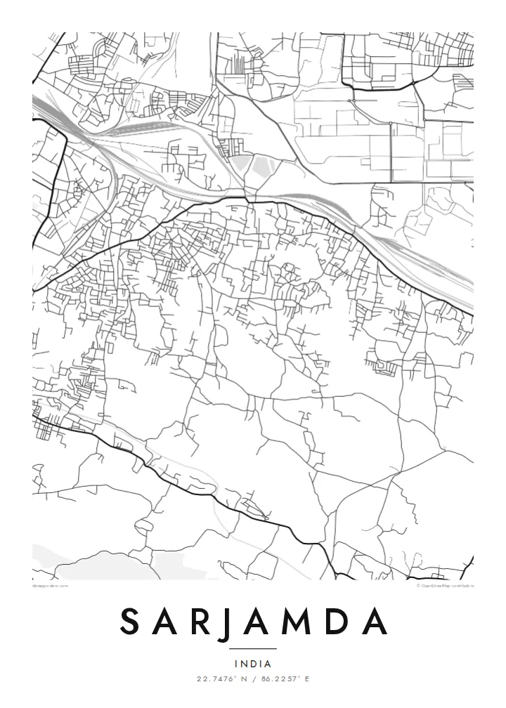
Sarjamda marks the edge of Jamshedpur's urban area, and the map shows the city's streets gradually loosening into more scattered settlement.
Qeeqabak kaartah poster · India
22.7476° N / 86.2257° E
A growing settlement on the southern edge of Jamshedpur, where city streets meet low hills and open plateau country.


Inki magaala, konoy gaba
Qande inkih tibbixeeh derre baguley table. Kulli qande missoowa caagid—daabbisimta, dirbaabu-le kaadu HD fayla akah.
 Cagalah pixels · 24 × 36″ daabbi fayla
Maxxaacah qeeqa
Tama usuk cagalah daabbi faylak 100% qambaala. Kulli poster — daabbisimta, dirbaabu-le kaadu download geytimta — ni-server-ittal 300 DPI-l ederimta, 7,200 × 10,800 pixels fanah, tokkel iyyi ellee catoy 24 × 36″ daabbi baxsi bahisak raaqu.
Gidarih


Kaarta
Sarjamda lies in East Singhbhum district of Jharkhand, on the southern fringe of Jamshedpur, the steel city that grew around the Tata works in the early twentieth century. On a map it sits at the meeting point of two patterns: the denser urban streets reaching out from the city, and the scattered villages, fields and wooded slopes of the Chota Nagpur plateau beyond.
The street layout is irregular and still evolving, with older village lanes, newer residential colonies and main roads leading toward the city centre. Open plots and patches of greenery sit between built-up areas, and low hills rise in the surrounding landscape, giving the map a mix of dense clusters and generous empty space that changes character from one edge to the other.
A Sarjamda map poster is a portrait of a place in transition, where the reach of a planned industrial city meets older rural settlement. Including part of Jamshedpur in a wider frame shows how the two connect. Digital HD files are $9 for six print sizes, each as a 300 DPI PNG and print-ready PDF, with no watermark.
Sarjamda marks the edge of Jamshedpur's urban area, and the map shows the city's streets gradually loosening into more scattered settlement.
Newer residential colonies with regular plots sit beside older, irregular village lanes, creating a varied texture that rewards a closer look at larger sizes.
Beyond the built-up area, the rolling ground of the Chota Nagpur plateau brings low hills and open land into the frame, giving the composition breathing room.
Kok tanim ab
Ayro, migaq hinnay kok tan xagar osis; gaba, ballaqa hinnay xiqa soorris.
Free preview qansarissi kee watermark-le. Daabbisimtaan kee HD fayla 300 DPI-l, 7,200 × 10,800 px fanah, watermark maleh ederimta.
Macah Sarjamda
Many families in Sarjamda have ties to Jamshedpur's industries and have watched the neighbourhood grow over the years. A map of the streets where they built a house or raised children captures that change at a particular moment in time.
You can personalise the title, subtitle and coordinates line, adding a family name, the year you moved in or a dedication. Choose from Classic black & white, Noir, Paper, Blueprint and Sand, and order a matte print with an optional wooden frame.
Sarjamda poster orme| Maxxaacah ballaqa | Qeeqa | Faylal |
|---|---|---|
| 30 × 40 cm (11.8 × 15.7″) | 3,543 × 4,724 px | PNG · PDF |
| 29.7 × 42 cm (A3, 11.7 × 16.5″) | 3,508 × 4,961 px | PNG · PDF |
| 42 × 59.4 cm (A2, 16.5 × 23.4″) | 4,961 × 7,016 px | PNG · PDF |
| 45.7 × 61 cm (18 × 24″) | 5,400 × 7,200 px | PNG · PDF |
| 50 × 70 cm (19.7 × 27.6″) | 5,906 × 8,268 px | PNG · PDF |
| 61 × 91.4 cm (24 × 36″) | 7,200 × 10,800 px | PNG · PDF |
Tabbaltah, limo-wayta xaqqa-le ablo 900 px ballaqa le, asta le, iskiriinih keh tan. HD faylal gexsoh inkih addal 8× fanah qeeqa le, poster ballaqa inkih addal meqeh maxxaacimta.
Baxxaqqa qari le qandiy dooriy, tohuk lakal Daabbisimtah Poster — kutuk kee, faxximek, dirbaabu — hinnay HD Digital Fayla dooru. Checkout inki wagitti geytima, kaadu ku-orme page keenih adissa akke waqdi caagoy kummite.
Usuk 200 gsm-le catam kutuk warqatal, lica katiy caagitte {printFrom}-ik hane ayta 30 × 40 cm-ik 24 × 36″ fanah, xaagu keenil warreeh.
Ee. Sarrah-le dirbaabu doori — bad, gudduc, oak-le hinnay bad-madabuy. Usuk finqisiimam ellee sange qarab-le kaadu qari umukku iyya keenih taagu. Dirbaabu-le poster {framedFrom}-ik hane, xaagu keenil warreeh.
Xaagu addunyal inkih cisab-le. Kulli poster 30+ ummattak ni-daabbi-mara mananih xayyoysa kaadu 3–7 caagu-ayróh fanah geeytima. Ku-orme kee xaagu tarikiy My Orders addal ablitta.
Geytimeek 14 ayróy addal foto naah rubbaay, cisab-le daabbisiynah hinnay ku-lacay gacisnaah.
Ee. Tama page-l edito addal, migaaq, subtitle kee coordinates sarrah faxxem fanah badal, kaadu qande kee katiy doori. Daabbisimtah, dirbaabu-le kaadu digital orme inkih ku-design cagalah yekkelen.
$9 bacisak 300 DPI PNG kee daabbisimtah adissime PDF fayla lica katiy inkih, watermark maleh, ayyi meki daabbisimtah geeytitta. Cisab makkoysemty ana? Awqak, watermark-le free preview download-eh.
Xayyo
