Channel shoreline
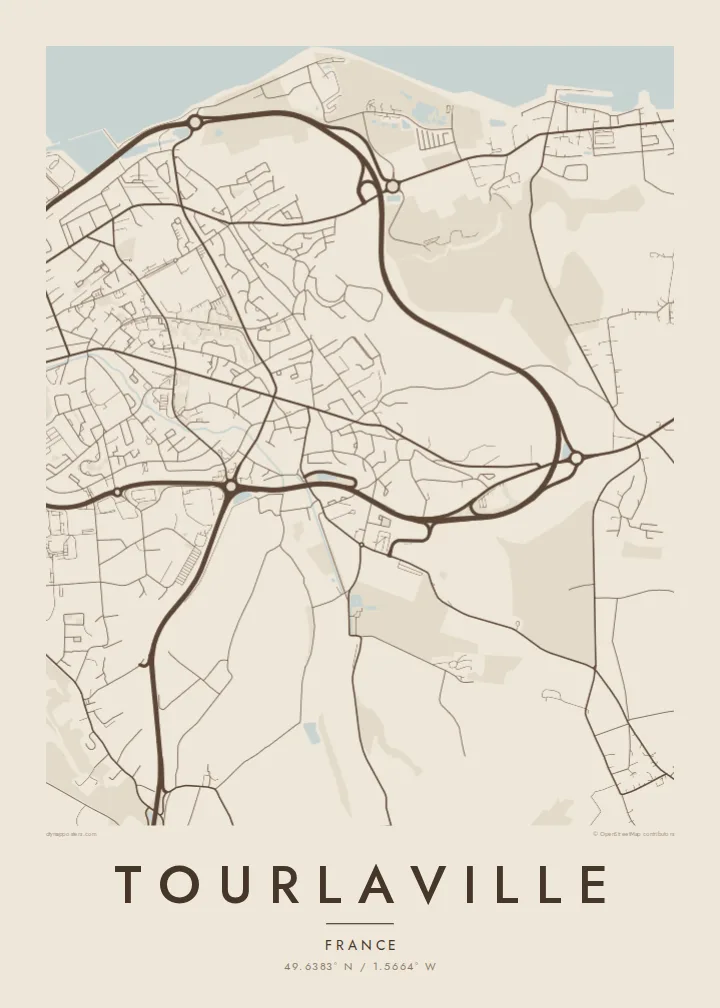
The northern edge of the map follows the Channel coast. Its long sweeping line frames the town and sets the composition's upper boundary.
Qeeqabak kaartah poster · France
49.6383° N / 1.5664° W
The eastern side of Cherbourg on the Cotentin coast, stretching from the Channel shore up into wooded valleys


Inki magaala, konoy gaba
Qande inkih tibbixeeh derre baguley table. Kulli qande missoowa caagid—daabbisimta, dirbaabu-le kaadu HD fayla akah.
 Cagalah pixels · 24 × 36″ daabbi fayla
Maxxaacah qeeqa
Tama usuk cagalah daabbi faylak 100% qambaala. Kulli poster — daabbisimta, dirbaabu-le kaadu download geytimta — ni-server-ittal 300 DPI-l ederimta, 7,200 × 10,800 pixels fanah, tokkel iyyi ellee catoy 24 × 36″ daabbi baxsi bahisak raaqu.
Gidarih


Kaarta
Tourlaville lies on the northern coast of the Cotentin peninsula in Normandy, immediately east of Cherbourg. In 2016 it merged with Cherbourg and neighbouring communes to form Cherbourg-en-Cotentin, but it retains a distinct identity and appears clearly on the map as its own area.
The commune stretches from the English Channel shoreline inland towards hills and valleys. Its best-known landmark is the Château des Ravalet, a Renaissance castle set in a park in the valley south of the town. From above, the streets become less dense as they move away from the coast into greener, more open land.
A Tourlaville map poster brings together the sea, the edge of a port city and the Normandy countryside. The print places the coastline across the top of the frame, with streets thinning out towards the valleys and the château grounds to the south.
The northern edge of the map follows the Channel coast. Its long sweeping line frames the town and sets the composition's upper boundary.
The Renaissance castle and its park sit in the valley south of the town. They appear as an open green area with formal paths among the wooded land.
To the west, Tourlaville's streets merge into Cherbourg. The poster shows where one district blends into the next.
Kok tanim ab
Ayro, migaq hinnay kok tan xagar osis; gaba, ballaqa hinnay xiqa soorris.
Free preview qansarissi kee watermark-le. Daabbisimtaan kee HD fayla 300 DPI-l, 7,200 × 10,800 px fanah, watermark maleh ederimta.
Macah Tourlaville
Tourlaville suits people who know the Cotentin: families, sailors, and those who have walked along the coast or visited the Ravalet gardens. A map captures that quiet corner of Normandy.
You can change the title, subtitle and coordinates line, choosing whether to use Tourlaville or Cherbourg-en-Cotentin. Then select one of five styles: Classic black and white, Noir, Paper, Blueprint or Sand.
Tourlaville poster orme| Maxxaacah ballaqa | Qeeqa | Faylal |
|---|---|---|
| 30 × 40 cm11.8 × 15.7″ | 3,543 × 4,724 px | PNG · PDF |
| 29.7 × 42 cm (A3)11.7 × 16.5″ | 3,508 × 4,961 px | PNG · PDF |
| 42 × 59.4 cm (A2)16.5 × 23.4″ | 4,961 × 7,016 px | PNG · PDF |
| 45.7 × 61 cm18 × 24″ | 5,400 × 7,200 px | PNG · PDF |
| 50 × 70 cm19.7 × 27.6″ | 5,906 × 8,268 px | PNG · PDF |
| 61 × 91.4 cm24 × 36″ | 7,200 × 10,800 px | PNG · PDF |
Tabbaltah, limo-wayta xaqqa-le ablo 900 px ballaqa le, asta le, iskiriinih keh tan. HD faylal gexsoh inkih addal 8× fanah qeeqa le, poster ballaqa inkih addal meqeh maxxaacimta.
Baxxaqqa qari le qandiy dooriy, tohuk lakal Daabbisimtah Poster — kutuk kee, faxximek, dirbaabu — hinnay HD Digital Fayla dooru. Checkout inki wagitti geytima, kaadu ku-orme page keenih adissa akke waqdi caagoy kummite.
Usuk 200 gsm-le catam kutuk warqatal, lica katiy caagitte $39-ik hane ayta 30 × 40 cm-ik 24 × 36″ fanah, xaagu keenil warreeh.
Ee. Sarrah-le dirbaabu doori — bad, gudduc, oak-le hinnay bad-madabuy. Usuk finqisiimam ellee sange qarab-le kaadu qari umukku iyya keenih taagu. Dirbaabu-le poster $99-ik hane, xaagu keenil warreeh.
Dirsa 60+ baaxoh bilsa. Poster kasa 30+ baaxoh nel print kaadu yan kee dirgeh kaxxa kee tanah printa, kee 3–7 xaqu ayyaamah yaaxigeeh. Xaaloo kee tracking "Ac Order" gexsitam. Kaadu baaxo 2–5 isbuuc yaaxigeeh, nanu dirsi yanin baaxoh sajiitah site ku kalah tekkeh.
Geytimeek 14 ayróy addal foto naah rubbaay, cisab-le daabbisiynah hinnay ku-lacay gacisnaah.
Ee. Tama page-l edito addal, migaaq, subtitle kee coordinates sarrah faxxem fanah badal, kaadu qande kee katiy doori. Daabbisimtah, dirbaabu-le kaadu digital orme inkih ku-design cagalah yekkelen.
$9 bacisak 300 DPI PNG kee daabbisimtah adissime PDF fayla lica katiy inkih, watermark maleh, ayyi meki daabbisimtah geeytitta. Cisab makkoysemty ana? Awqak, watermark-le free preview download-eh.
