Looping residential streets
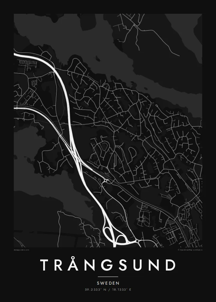
Streets curve around rocky high ground and end in crescents and turning circles, a pattern that fills the map with soft, repeating shapes instead of straight blocks.
Qeeqabak kaartah poster · Sweden
59.2333° N / 18.1333° E
A wooded suburb south of Stockholm, curving residential streets set between rocky forest, a commuter rail line and lakeshore



Inki magaala, konoy gaba
Qande inkih tibbixeeh derre baguley table. Kulli qande missoowa caagid—daabbisimta, dirbaabu-le kaadu HD fayla akah.
 Cagalah pixels · 24 × 36″ daabbi fayla
Maxxaacah qeeqa
Tama usuk cagalah daabbi faylak 100% qambaala. Kulli poster — daabbisimta, dirbaabu-le kaadu download geytimta — ni-server-ittal 300 DPI-l ederimta, 7,200 × 10,800 pixels fanah, tokkel iyyi ellee catoy 24 × 36″ daabbi baxsi bahisak raaqu.
Gidarih


Kaarta
Trångsund is a residential locality in Huddinge Municipality, south of central Stockholm. Its name translates roughly as narrow sound, and the map suits it: a settlement drawn tightly between forest, rock and water. Streets here rarely run straight. They loop and curl around the uneven granite terrain of the Stockholm region, forming closed crescents and cul-de-sacs rather than a grid.
The Nynäs commuter rail line runs through the area, and the station gives the neighbourhood a clear anchor. Housing clusters within walking distance of the line, then thins toward the surrounding woodland. To the east, the shoreline of Drevviken brings a broad, pale shape into the drawing, a calm counterweight to the busy pattern of residential streets.
A Trångsund map poster captures something typical of Stockholm suburbs: the city's reach is visible in the railway and the roads that lead north, but the character is local, green and quiet. At poster scale, curving streets, blank patches of forest and the lake's edge combine into a composition that feels closer to a landscape study than a city plan.
Streets curve around rocky high ground and end in crescents and turning circles, a pattern that fills the map with soft, repeating shapes instead of straight blocks.
The Nynäs line cuts a steady, direct path through the locality, a firm straight line that contrasts with the winding streets and marks the connection to Stockholm.
The lake's western shore sets a broad, open edge on one side of the map, giving the composition room to breathe and a natural boundary to the neighbourhood.
Kok tanim ab
Ayro, migaq hinnay kok tan xagar osis; gaba, ballaqa hinnay xiqa soorris.
Free preview qansarissi kee watermark-le. Daabbisimtaan kee HD fayla 300 DPI-l, 7,200 × 10,800 px fanah, watermark maleh ederimta.
Macah Trångsund
Trångsund is the kind of place people choose for a family home, and a map of it tends to mark that moment: a first flat, a house near the lake, a daily train into the city. Its curving streets and forest gaps make a calm, graphic print.
The title, subtitle and coordinates line are all editable, so you can add an address or a moving-in year. Choose Classic black & white, Noir, Paper, Blueprint or Sand. Download a free 900 px preview first, then order HD files for $9 or a print shipped from a partner near you.
Trångsund poster orme| Maxxaacah ballaqa | Qeeqa | Faylal |
|---|---|---|
| 30 × 40 cm (11.8 × 15.7″) | 3,543 × 4,724 px | PNG · PDF |
| 29.7 × 42 cm (A3, 11.7 × 16.5″) | 3,508 × 4,961 px | PNG · PDF |
| 42 × 59.4 cm (A2, 16.5 × 23.4″) | 4,961 × 7,016 px | PNG · PDF |
| 45.7 × 61 cm (18 × 24″) | 5,400 × 7,200 px | PNG · PDF |
| 50 × 70 cm (19.7 × 27.6″) | 5,906 × 8,268 px | PNG · PDF |
| 61 × 91.4 cm (24 × 36″) | 7,200 × 10,800 px | PNG · PDF |
Tabbaltah, limo-wayta xaqqa-le ablo 900 px ballaqa le, asta le, iskiriinih keh tan. HD faylal gexsoh inkih addal 8× fanah qeeqa le, poster ballaqa inkih addal meqeh maxxaacimta.
Baxxaqqa qari le qandiy dooriy, tohuk lakal Daabbisimtah Poster — kutuk kee, faxximek, dirbaabu — hinnay HD Digital Fayla dooru. Checkout inki wagitti geytima, kaadu ku-orme page keenih adissa akke waqdi caagoy kummite.
Usuk 200 gsm-le catam kutuk warqatal, lica katiy caagitte {printFrom}-ik hane ayta 30 × 40 cm-ik 24 × 36″ fanah, xaagu keenil warreeh.
Ee. Sarrah-le dirbaabu doori — bad, gudduc, oak-le hinnay bad-madabuy. Usuk finqisiimam ellee sange qarab-le kaadu qari umukku iyya keenih taagu. Dirbaabu-le poster {framedFrom}-ik hane, xaagu keenil warreeh.
Xaagu addunyal inkih cisab-le. Kulli poster 30+ ummattak ni-daabbi-mara mananih xayyoysa kaadu 3–7 caagu-ayróh fanah geeytima. Ku-orme kee xaagu tarikiy My Orders addal ablitta.
Geytimeek 14 ayróy addal foto naah rubbaay, cisab-le daabbisiynah hinnay ku-lacay gacisnaah.
Ee. Tama page-l edito addal, migaaq, subtitle kee coordinates sarrah faxxem fanah badal, kaadu qande kee katiy doori. Daabbisimtah, dirbaabu-le kaadu digital orme inkih ku-design cagalah yekkelen.
$9 bacisak 300 DPI PNG kee daabbisimtah adissime PDF fayla lica katiy inkih, watermark maleh, ayyi meki daabbisimtah geeytitta. Cisab makkoysemty ana? Awqak, watermark-le free preview download-eh.
