Whanganui River
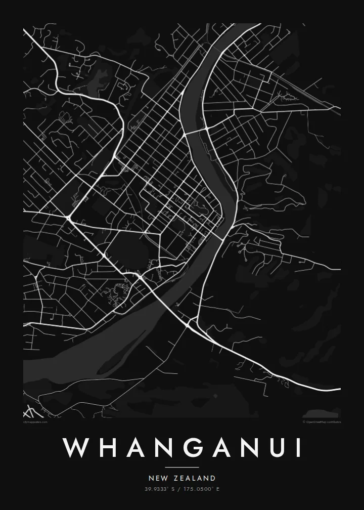
The river enters in broad loops and flows past the centre to the sea. Its wide, curving course gives the poster a strong natural line against the straight streets on either side.
Qeeqabak kaartah poster · New Zealand
39.9333° S / 175.0500° E
A river city on New Zealand's west coast, gathered around the last broad bends of the Whanganui before the Tasman Sea.



Inki magaala, konoy gaba
Qande inkih tibbixeeh derre baguley table. Kulli qande missoowa caagid—daabbisimta, dirbaabu-le kaadu HD fayla akah.
 Cagalah pixels · 24 × 36″ daabbi fayla
Maxxaacah qeeqa
Tama usuk cagalah daabbi faylak 100% qambaala. Kulli poster — daabbisimta, dirbaabu-le kaadu download geytimta — ni-server-ittal 300 DPI-l ederimta, 7,200 × 10,800 pixels fanah, tokkel iyyi ellee catoy 24 × 36″ daabbi baxsi bahisak raaqu.
Gidarih


Kaarta
Whanganui sits near the mouth of the Whanganui River on the southwest coast of the North Island. The river is the centre of the map: it sweeps in from the north in wide bends, passes the city centre and runs out to the Tasman Sea a few kilometres downstream. Streets spread across both banks, with the main commercial grid on the western side.
Several bridges link the two halves of the city, and on the eastern bank the ground rises sharply to Durie Hill, reached by a tunnel and an elevator opened in 1919. In 2017 the Whanganui River became the first river in the world to be recognised as a legal person, a status tied to its importance to local iwi. A Whanganui map poster puts that river at the heart of the design.
Away from the river, the city opens into a regular grid of suburbs, parks and reserves, with the coastline and dunes to the southwest. The centre keeps many Victorian and Edwardian buildings, though on the map it is the structure that matters: long straight streets meeting the soft curves of the water.
The river enters in broad loops and flows past the centre to the sea. Its wide, curving course gives the poster a strong natural line against the straight streets on either side.
On the eastern bank, the land climbs steeply. Streets there follow the contours, and the hill's elevator, built into the slope, links it to the river flats below.
Near the coast, the river meets the Tasman Sea between sandy shores and stone moles. Including the mouth in the frame adds a clean coastal edge to the composition.
Kok tanim ab
Ayro, migaq hinnay kok tan xagar osis; gaba, ballaqa hinnay xiqa soorris.
Free preview qansarissi kee watermark-le. Daabbisimtaan kee HD fayla 300 DPI-l, 7,200 × 10,800 px fanah, watermark maleh ederimta.
Macah Whanganui
Whanganui matters to people who grew up by the river, rowed on it or travelled its length by canoe. A map of the city keeps that bond in view with a simple, honest image of streets and water.
Choose a title in English or te reo Māori, add a subtitle such as a date, and edit the coordinates line if you wish. Five styles are available, from Classic black & white to Blueprint. Order a matte print or download the $9 HD files.
Whanganui poster orme| Maxxaacah ballaqa | Qeeqa | Faylal |
|---|---|---|
| 30 × 40 cm11.8 × 15.7″ | 3,543 × 4,724 px | PNG · PDF |
| 29.7 × 42 cm (A3)11.7 × 16.5″ | 3,508 × 4,961 px | PNG · PDF |
| 42 × 59.4 cm (A2)16.5 × 23.4″ | 4,961 × 7,016 px | PNG · PDF |
| 45.7 × 61 cm18 × 24″ | 5,400 × 7,200 px | PNG · PDF |
| 50 × 70 cm19.7 × 27.6″ | 5,906 × 8,268 px | PNG · PDF |
| 61 × 91.4 cm24 × 36″ | 7,200 × 10,800 px | PNG · PDF |
Tabbaltah, limo-wayta xaqqa-le ablo 900 px ballaqa le, asta le, iskiriinih keh tan. HD faylal gexsoh inkih addal 8× fanah qeeqa le, poster ballaqa inkih addal meqeh maxxaacimta.
Baxxaqqa qari le qandiy dooriy, tohuk lakal Daabbisimtah Poster — kutuk kee, faxximek, dirbaabu — hinnay HD Digital Fayla dooru. Checkout inki wagitti geytima, kaadu ku-orme page keenih adissa akke waqdi caagoy kummite.
Usuk 200 gsm-le catam kutuk warqatal, lica katiy caagitte $39-ik hane ayta 30 × 40 cm-ik 24 × 36″ fanah, xaagu keenil warreeh.
Ee. Sarrah-le dirbaabu doori — bad, gudduc, oak-le hinnay bad-madabuy. Usuk finqisiimam ellee sange qarab-le kaadu qari umukku iyya keenih taagu. Dirbaabu-le poster $99-ik hane, xaagu keenil warreeh.
Dirsa 60+ baaxoh bilsa. Poster kasa 30+ baaxoh nel print kaadu yan kee dirgeh kaxxa kee tanah printa, kee 3–7 xaqu ayyaamah yaaxigeeh. Xaaloo kee tracking "Ac Order" gexsitam. Kaadu baaxo 2–5 isbuuc yaaxigeeh, nanu dirsi yanin baaxoh sajiitah site ku kalah tekkeh.
Geytimeek 14 ayróy addal foto naah rubbaay, cisab-le daabbisiynah hinnay ku-lacay gacisnaah.
Ee. Tama page-l edito addal, migaaq, subtitle kee coordinates sarrah faxxem fanah badal, kaadu qande kee katiy doori. Daabbisimtah, dirbaabu-le kaadu digital orme inkih ku-design cagalah yekkelen.
$9 bacisak 300 DPI PNG kee daabbisimtah adissime PDF fayla lica katiy inkih, watermark maleh, ayyi meki daabbisimtah geeytitta. Cisab makkoysemty ana? Awqak, watermark-le free preview download-eh.
Xayyo
