Promenade des Anglais
The seafront boulevard follows the Baie des Anges for several kilometres, drawing the city's defining curve from the airport to the foot of Castle Hill.
ملصق خريطة بسيط · فرنسا
43.7031° N / 7.2661° E
A curved bay on the Riviera, with the Promenade des Anglais, a tight old town and hills climbing behind


مدينة واحدة، خمسة أمزجة
اضغط على أي نمط لتراه على الحائط. جميع الأنماط بنفس السعر — مطبوعة أو مؤطرة أو كملفات HD.
 بكسلات حقيقية · ملف طباعة 24 × 36 بوصة
حدّة الطباعة
هذا اقتصاص 100% من ملف الطباعة الحقيقي. كل بوستر — مطبوع أو مؤطر أو منزّل — يُعالَج على خوادمنا بدقة 300 DPI، وصولًا إلى 7,200 × 10,800 بكسل، لتبقى أدق الشوارع واضحة حتى على طباعة 24 × 36 بوصة.
على الحائط


الخريطة
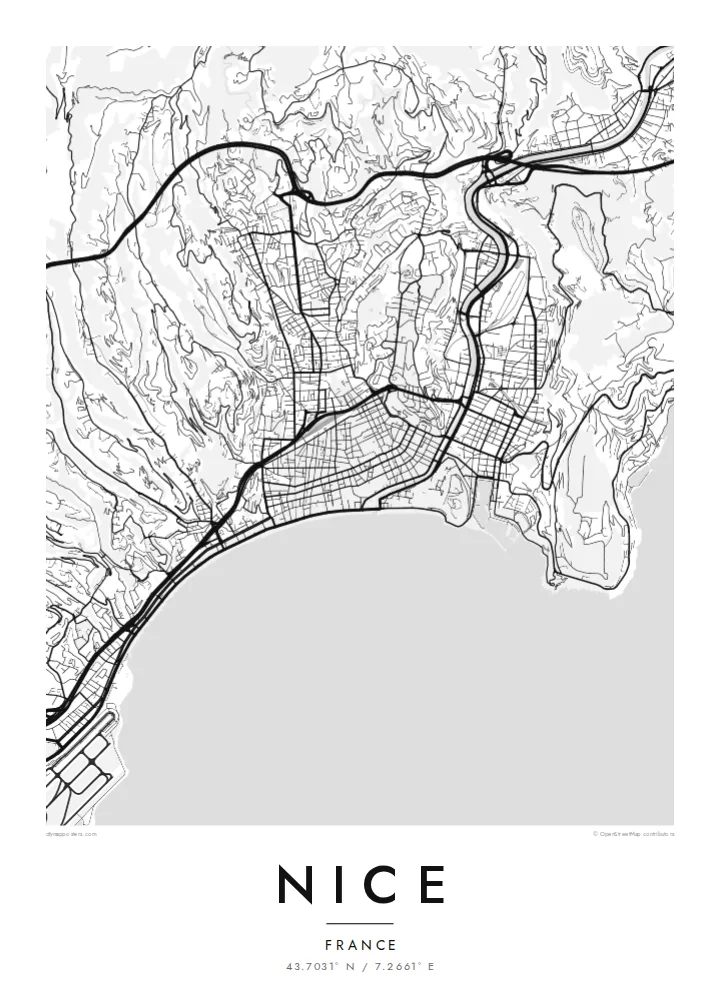
Nice lies on the Baie des Anges, the Bay of Angels, on France's Mediterranean coast near the Italian border. Its map opens with one of the most recognisable waterfronts in Europe: the Promenade des Anglais, following the pebbled shore in a long, gentle curve from the airport towards the old town. Behind it the city climbs into hills of villas and winding roads.
At the eastern end of the bay, Vieux Nice packs narrow lanes into a dense triangle below Castle Hill, the rocky promontory that separates the old town from the port. The Paillon river, now covered, runs beneath a long green promenade that divides the old quarter from the nineteenth-century city with its broad streets and squares.
On the hill of Cimiez stand Roman remains and the Matisse Museum, and in 2021 Nice was added to UNESCO's World Heritage List as the winter resort town of the Riviera. A Nice map poster shows how clearly these layers fit together: the bay, the old town, the port, the green line of the Paillon and the hills above.
The seafront boulevard follows the Baie des Anges for several kilometres, drawing the city's defining curve from the airport to the foot of Castle Hill.
The old town's narrow, closely packed lanes create the densest texture on the map, a triangle of streets pressed between the sea, Castle Hill and the Paillon promenade.
East of Castle Hill the harbour forms a neat, nearly rectangular basin cut into the coast, surrounded by streets that slope up towards the hills.
اجعله خاصًا بك
أضف تاريخًا أو اسمًا أو عبارة خاصة بك، وغيّر النمط أو المقاس أو الاتجاه.
المعاينة المجانية منخفضة الدقة وتحمل علامة مائية. المطبوعات وملفات HD تُعالَج بدقة 300 DPI، وصولًا إلى 7,200 × 10,800 بكسل، بلا علامة مائية.
لماذا Nice
Nice is a city of holidays, long stays and new beginnings, loved by residents and visitors alike. Its map, with the sweep of the bay and the dense old town, makes a graceful reminder of a summer, a honeymoon or a first apartment by the sea.
Personalise the title, subtitle and coordinates line, and choose Classic black & white, Noir, Paper, Blueprint or Sand. Download HD files for $9, or order a matte printed poster from partners in 30+ countries, with an optional wooden frame.
اطلب بوستر Nice| مقاس الطباعة | الدقة | الملفات |
|---|---|---|
| 30 × 40 cm (11.8 × 15.7″) | 3,543 × 4,724 px | PNG · PDF |
| 29.7 × 42 cm (A3, 11.7 × 16.5″) | 3,508 × 4,961 px | PNG · PDF |
| 42 × 59.4 cm (A2, 16.5 × 23.4″) | 4,961 × 7,016 px | PNG · PDF |
| 45.7 × 61 cm (18 × 24″) | 5,400 × 7,200 px | PNG · PDF |
| 50 × 70 cm (19.7 × 27.6″) | 5,906 × 8,268 px | PNG · PDF |
| 61 × 91.4 cm (24 × 36″) | 7,200 × 10,800 px | PNG · PDF |
للمقارنة، يبلغ عرض المعاينة المجانية 900 بكسل، وتحمل علامة مائية ومخصصة للشاشات. أما ملفات HD فدقتها أعلى بما يصل إلى 8 أضعاف في كل اتجاه، وتُطبع بوضوح تام بالمقاس الكامل للملصق.
اختر نمطًا من أعلى الصفحة، ثم اختر بوستر مطبوع — بحجم وإطار إن أردت — أو ملفات HD رقمية. الدفع يتم بخطوة واحدة، وتتحدّث صفحة طلبك فور إتمام الدفع.
يُطبع على ورق مطفي فاخر بوزن 200 جرام بأحد ستة مقاسات، من 30 × 40 سم إلى 24 × 36 بوصة. تبدأ أسعار البوسترات المطبوعة من {printFrom}، والشحن مشمول.
نعم. اختر إطارًا من الخشب الصلب باللون الأسود أو الأبيض أو خشب البلوط الطبيعي أو الخشب الداكن. يأتي بزجاج مقاوم للكسر وجاهز للتعليق مباشرة. تبدأ أسعار البوسترات المؤطرة من {framedFrom}، والشحن مشمول.
الشحن مجاني حول العالم. يُطبع كل بوستر لدى أقرب شريك طباعة لدينا في أكثر من 30 دولة، وعادة ما يصل خلال 3–7 أيام عمل. يمكنك متابعة الحالة ورقم التتبع من صفحة طلباتي.
أرسل لنا صورة خلال 14 يومًا من الاستلام، وسنعيد الطباعة مجانًا أو نرد المبلغ.
نعم. من المحرر في هذه الصفحة، غيّر العنوان والعنوان الفرعي وسطر الإحداثيات كما تشاء، واختر النمط والحجم. الطلبات المطبوعة والمؤطرة والرقمية تستخدم تصميمك بالضبط.
مقابل $9 تحصل على ملفات PNG بدقة 300 DPI وملفات PDF جاهزة للطباعة بجميع المقاسات الستة، بلا علامة مائية، لطباعتها في أي مكان. لست متأكدًا بعد؟ نزّل معاينة مجانية بعلامة مائية أولًا.
