Railway arcs
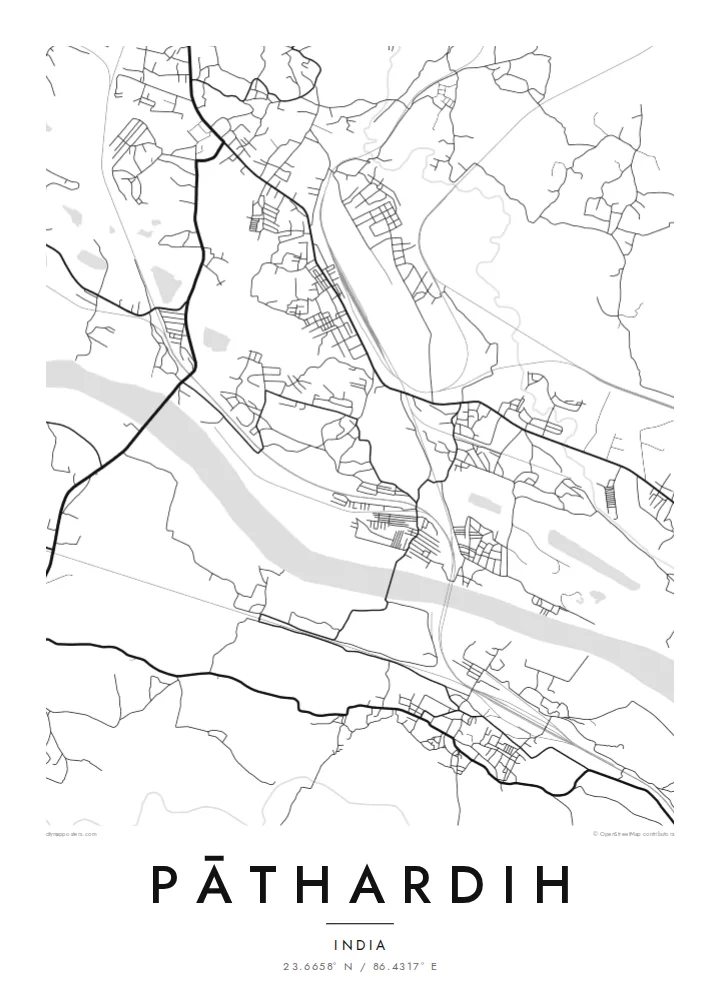
Rail lines and sidings sweep through the area in long curves, linking mines and yards. On the poster they form some of the strongest lines, cutting through the finer mesh of local lanes.
ملصق خريطة بسيط · الهند
23.6658° N / 86.4317° E
Winding lanes, railway lines and mining ground in the coalfield country of Dhanbad district, Jharkhand.


مدينة واحدة، خمسة أمزجة
اضغط على أي نمط لتراه على الحائط. جميع الأنماط بنفس السعر — مطبوعة أو مؤطرة أو كملفات HD.
 بكسلات حقيقية · ملف طباعة 24 × 36 بوصة
حدّة الطباعة
هذا اقتصاص 100% من ملف الطباعة الحقيقي. كل بوستر — مطبوع أو مؤطر أو منزّل — يُعالَج على خوادمنا بدقة 300 DPI، وصولًا إلى 7,200 × 10,800 بكسل، لتبقى أدق الشوارع واضحة حتى على طباعة 24 × 36 بوصة.
على الحائط


الخريطة
Pāthardih is a town in the Dhanbad district of Jharkhand, in the coal-mining belt that has defined this part of eastern India for more than a century. Its map is not built around a single centre. Instead, clusters of housing, colliery settlements and market streets are strung along roads and rail lines, with open or worked ground between them.
The coal industry leaves a distinctive imprint from above. Railway sidings curve across the landscape to serve mines and washeries, roads bend around worked areas, and patches of water sit where the ground has been excavated. The result is a street pattern shaped less by planning than by the needs of industry over many decades.
A Pāthardih map poster captures that working geography with unusual honesty. The fragmented settlement, the long arcs of track and the irregular blocks between them produce a complex, layered composition. It is a meaningful keepsake for families with ties to the Dhanbad coalfields and for anyone drawn to industrial landscapes.
Rail lines and sidings sweep through the area in long curves, linking mines and yards. On the poster they form some of the strongest lines, cutting through the finer mesh of local lanes.
Rather than one dense core, the town is a series of neighbourhoods and colony-style clusters spread across the landscape, giving the print an intriguing, patchwork structure.
Open areas, water-filled hollows and irregular gaps between streets reflect decades of mining. Rendered in black and white, these spaces add contrast and a sense of scale to the map.
اجعله خاصًا بك
أضف تاريخًا أو اسمًا أو عبارة خاصة بك، وغيّر النمط أو المقاس أو الاتجاه.
المعاينة المجانية منخفضة الدقة وتحمل علامة مائية. المطبوعات وملفات HD تُعالَج بدقة 300 DPI، وصولًا إلى 7,200 × 10,800 بكسل، بلا علامة مائية.
لماذا Pāthardih
For many people Pāthardih stands for a parent's working life, a childhood in a colliery colony or a family story tied to coal. A map poster keeps that place on the wall, with the title and subtitle personalised to a family name, a year or a few words of your own.
Pick one of five styles: Classic black & white, Noir, Paper, Blueprint or Sand. Blueprint suits the industrial character especially well. The $9 digital download includes six sizes as 300 DPI PNG and PDF files without a watermark, and printed posters are available too.
اطلب بوستر Pāthardih| مقاس الطباعة | الدقة | الملفات |
|---|---|---|
| 30 × 40 cm (11.8 × 15.7″) | 3,543 × 4,724 px | PNG · PDF |
| 29.7 × 42 cm (A3, 11.7 × 16.5″) | 3,508 × 4,961 px | PNG · PDF |
| 42 × 59.4 cm (A2, 16.5 × 23.4″) | 4,961 × 7,016 px | PNG · PDF |
| 45.7 × 61 cm (18 × 24″) | 5,400 × 7,200 px | PNG · PDF |
| 50 × 70 cm (19.7 × 27.6″) | 5,906 × 8,268 px | PNG · PDF |
| 61 × 91.4 cm (24 × 36″) | 7,200 × 10,800 px | PNG · PDF |
للمقارنة، يبلغ عرض المعاينة المجانية 900 بكسل، وتحمل علامة مائية ومخصصة للشاشات. أما ملفات HD فدقتها أعلى بما يصل إلى 8 أضعاف في كل اتجاه، وتُطبع بوضوح تام بالمقاس الكامل للملصق.
اختر نمطًا من أعلى الصفحة، ثم اختر بوستر مطبوع — بحجم وإطار إن أردت — أو ملفات HD رقمية. الدفع يتم بخطوة واحدة، وتتحدّث صفحة طلبك فور إتمام الدفع.
يُطبع على ورق مطفي فاخر بوزن 200 جرام بأحد ستة مقاسات، من 30 × 40 سم إلى 24 × 36 بوصة. تبدأ أسعار البوسترات المطبوعة من {printFrom}، والشحن مشمول.
نعم. اختر إطارًا من الخشب الصلب باللون الأسود أو الأبيض أو خشب البلوط الطبيعي أو الخشب الداكن. يأتي بزجاج مقاوم للكسر وجاهز للتعليق مباشرة. تبدأ أسعار البوسترات المؤطرة من {framedFrom}، والشحن مشمول.
الشحن مجاني حول العالم. يُطبع كل بوستر لدى أقرب شريك طباعة لدينا في أكثر من 30 دولة، وعادة ما يصل خلال 3–7 أيام عمل. يمكنك متابعة الحالة ورقم التتبع من صفحة طلباتي.
أرسل لنا صورة خلال 14 يومًا من الاستلام، وسنعيد الطباعة مجانًا أو نرد المبلغ.
نعم. من المحرر في هذه الصفحة، غيّر العنوان والعنوان الفرعي وسطر الإحداثيات كما تشاء، واختر النمط والحجم. الطلبات المطبوعة والمؤطرة والرقمية تستخدم تصميمك بالضبط.
مقابل $9 تحصل على ملفات PNG بدقة 300 DPI وملفات PDF جاهزة للطباعة بجميع المقاسات الستة، بلا علامة مائية، لطباعتها في أي مكان. لست متأكدًا بعد؟ نزّل معاينة مجانية بعلامة مائية أولًا.
بالقرب منك
