Looping residential streets
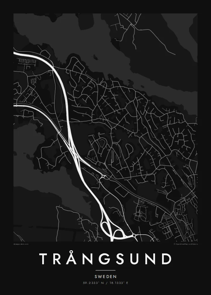
Streets curve around rocky high ground and end in crescents and turning circles, a pattern that fills the map with soft, repeating shapes instead of straight blocks.
ملصق خريطة بسيط · السويد
59.2333° N / 18.1333° E
A wooded suburb south of Stockholm, curving residential streets set between rocky forest, a commuter rail line and lakeshore



مدينة واحدة، خمسة أمزجة
اضغط على أي نمط لتراه على الحائط. جميع الأنماط بنفس السعر — مطبوعة أو مؤطرة أو كملفات HD.
 بكسلات حقيقية · ملف طباعة 24 × 36 بوصة
حدّة الطباعة
هذا اقتصاص 100% من ملف الطباعة الحقيقي. كل بوستر — مطبوع أو مؤطر أو منزّل — يُعالَج على خوادمنا بدقة 300 DPI، وصولًا إلى 7,200 × 10,800 بكسل، لتبقى أدق الشوارع واضحة حتى على طباعة 24 × 36 بوصة.
على الحائط


الخريطة
Trångsund is a residential locality in Huddinge Municipality, south of central Stockholm. Its name translates roughly as narrow sound, and the map suits it: a settlement drawn tightly between forest, rock and water. Streets here rarely run straight. They loop and curl around the uneven granite terrain of the Stockholm region, forming closed crescents and cul-de-sacs rather than a grid.
The Nynäs commuter rail line runs through the area, and the station gives the neighbourhood a clear anchor. Housing clusters within walking distance of the line, then thins toward the surrounding woodland. To the east, the shoreline of Drevviken brings a broad, pale shape into the drawing, a calm counterweight to the busy pattern of residential streets.
A Trångsund map poster captures something typical of Stockholm suburbs: the city's reach is visible in the railway and the roads that lead north, but the character is local, green and quiet. At poster scale, curving streets, blank patches of forest and the lake's edge combine into a composition that feels closer to a landscape study than a city plan.
Streets curve around rocky high ground and end in crescents and turning circles, a pattern that fills the map with soft, repeating shapes instead of straight blocks.
The Nynäs line cuts a steady, direct path through the locality, a firm straight line that contrasts with the winding streets and marks the connection to Stockholm.
The lake's western shore sets a broad, open edge on one side of the map, giving the composition room to breathe and a natural boundary to the neighbourhood.
اجعله خاصًا بك
أضف تاريخًا أو اسمًا أو عبارة خاصة بك، وغيّر النمط أو المقاس أو الاتجاه.
المعاينة المجانية منخفضة الدقة وتحمل علامة مائية. المطبوعات وملفات HD تُعالَج بدقة 300 DPI، وصولًا إلى 7,200 × 10,800 بكسل، بلا علامة مائية.
لماذا Trångsund
Trångsund is the kind of place people choose for a family home, and a map of it tends to mark that moment: a first flat, a house near the lake, a daily train into the city. Its curving streets and forest gaps make a calm, graphic print.
The title, subtitle and coordinates line are all editable, so you can add an address or a moving-in year. Choose Classic black & white, Noir, Paper, Blueprint or Sand. Download a free 900 px preview first, then order HD files for $9 or a print shipped from a partner near you.
اطلب بوستر Trångsund| مقاس الطباعة | الدقة | الملفات |
|---|---|---|
| 30 × 40 cm (11.8 × 15.7″) | 3,543 × 4,724 px | PNG · PDF |
| 29.7 × 42 cm (A3, 11.7 × 16.5″) | 3,508 × 4,961 px | PNG · PDF |
| 42 × 59.4 cm (A2, 16.5 × 23.4″) | 4,961 × 7,016 px | PNG · PDF |
| 45.7 × 61 cm (18 × 24″) | 5,400 × 7,200 px | PNG · PDF |
| 50 × 70 cm (19.7 × 27.6″) | 5,906 × 8,268 px | PNG · PDF |
| 61 × 91.4 cm (24 × 36″) | 7,200 × 10,800 px | PNG · PDF |
للمقارنة، يبلغ عرض المعاينة المجانية 900 بكسل، وتحمل علامة مائية ومخصصة للشاشات. أما ملفات HD فدقتها أعلى بما يصل إلى 8 أضعاف في كل اتجاه، وتُطبع بوضوح تام بالمقاس الكامل للملصق.
اختر نمطًا من أعلى الصفحة، ثم اختر بوستر مطبوع — بحجم وإطار إن أردت — أو ملفات HD رقمية. الدفع يتم بخطوة واحدة، وتتحدّث صفحة طلبك فور إتمام الدفع.
يُطبع على ورق مطفي فاخر بوزن 200 جرام بأحد ستة مقاسات، من 30 × 40 سم إلى 24 × 36 بوصة. تبدأ أسعار البوسترات المطبوعة من {printFrom}، والشحن مشمول.
نعم. اختر إطارًا من الخشب الصلب باللون الأسود أو الأبيض أو خشب البلوط الطبيعي أو الخشب الداكن. يأتي بزجاج مقاوم للكسر وجاهز للتعليق مباشرة. تبدأ أسعار البوسترات المؤطرة من {framedFrom}، والشحن مشمول.
الشحن مجاني حول العالم. يُطبع كل بوستر لدى أقرب شريك طباعة لدينا في أكثر من 30 دولة، وعادة ما يصل خلال 3–7 أيام عمل. يمكنك متابعة الحالة ورقم التتبع من صفحة طلباتي.
أرسل لنا صورة خلال 14 يومًا من الاستلام، وسنعيد الطباعة مجانًا أو نرد المبلغ.
نعم. من المحرر في هذه الصفحة، غيّر العنوان والعنوان الفرعي وسطر الإحداثيات كما تشاء، واختر النمط والحجم. الطلبات المطبوعة والمؤطرة والرقمية تستخدم تصميمك بالضبط.
مقابل $9 تحصل على ملفات PNG بدقة 300 DPI وملفات PDF جاهزة للطباعة بجميع المقاسات الستة، بلا علامة مائية، لطباعتها في أي مكان. لست متأكدًا بعد؟ نزّل معاينة مجانية بعلامة مائية أولًا.
