Railway lines
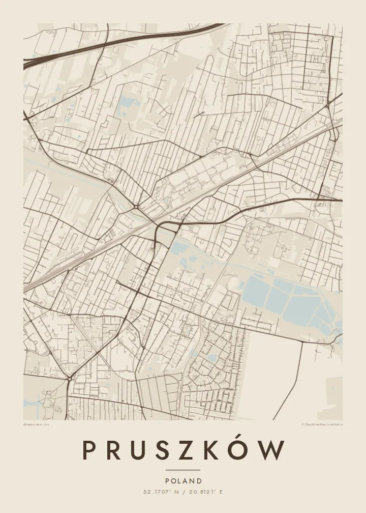
Main and commuter rail lines cross Pruszków and link it to Warsaw. On the map they form long, straight lines that divide the town into sections.
Minimalistički poster mape · Poljska
52.1707° N / 20.8121° E
A railway suburb west of Warsaw, its streets strung along commuter lines and the small Utrata River


Jedan grad, pet raspoloženja
Dodirnite stil da ga vidite na zidu. Svi stilovi koštaju isto — bilo da su odštampani, uramljeni ili kao HD fajlovi.
 Stvarni pikseli · fajl za štampu 24 × 36″
Oštro za štampu
Ovo je isječak u punoj veličini (100%) stvarnog fajla za štampu. Svaki poster — odštampan, uramljen ili preuzet — renderuje se na našim serverima u rezoluciji 300 DPI, do 7,200 × 10,800 piksela, tako da čak i najsitnije ulice ostaju oštre na otisku 24 × 36″.
Na zidu


Mapa
Pruszków lies just west of Warsaw, part of the ring of towns that have grown around the capital. On the map, railway lines are its backbone. The main line to the west and the local WKD commuter railway run through town, and neighbourhoods have grown up around the stations. The small Utrata River winds across the area, with parks and green space along parts of its banks.
Pruszków grew as an industrial town in the nineteenth and twentieth centuries, with factories and rail workshops. After the Warsaw Uprising in 1944, a transit camp was set up in the town's railway works, and hundreds of thousands of Warsaw residents passed through it. That history is now marked by a museum and memorial. Today, the town is mostly a commuter suburb connected closely to Warsaw.
A Pruszków map poster shows a clear, practical structure: railway lines cutting across the map, a mix of old blocks and newer estates, and the soft curve of the Utrata between them. It is a typical Central European suburb seen from above, with just enough variety to make an interesting, balanced print.
Main and commuter rail lines cross Pruszków and link it to Warsaw. On the map they form long, straight lines that divide the town into sections.
This small river winds through the town with green space along its banks. Its curves soften the straight lines of the railways and streets.
Older streets near the centre sit beside housing estates and single-family areas. The mix of block sizes gives the poster a varied texture.
Učinite ga svojim
Dodajte datum, ime ili vlastiti tekst, promijenite stil, veličinu ili orijentaciju.
Besplatan pregled je niske rezolucije sa vodenim žigom. Štampani posteri i HD fajlovi se renderuju u rezoluciji 300 DPI, do 7,200 × 10,800 px, bez vodenog žiga.
Zašto Pruszków
For people who grew up in Pruszków or now commute from there to Warsaw, the map shows a familiar web of stations, streets and river walks. It makes a thoughtful gift for a new home.
The title, subtitle and coordinates line can be personalised with a name, an address or a date. Choose one of five styles: Classic black & white, Noir, Paper, Blueprint or Sand.
Naručite poster Pruszków| Veličina printa | Rezolucija | Fajlovi |
|---|---|---|
| 30 × 40 cm11.8 × 15.7″ | 3,543 × 4,724 px | PNG · PDF |
| 29.7 × 42 cm (A3)11.7 × 16.5″ | 3,508 × 4,961 px | PNG · PDF |
| 42 × 59.4 cm (A2)16.5 × 23.4″ | 4,961 × 7,016 px | PNG · PDF |
| 45.7 × 61 cm18 × 24″ | 5,400 × 7,200 px | PNG · PDF |
| 50 × 70 cm19.7 × 27.6″ | 5,906 × 8,268 px | PNG · PDF |
| 61 × 91.4 cm24 × 36″ | 7,200 × 10,800 px | PNG · PDF |
Poređenja radi, besplatni pregled je širok 900 px, ima vodeni žig i namijenjen je ekranima. HD fajlovi imaju do 8× veću rezoluciju u svakom smjeru i čisto se štampaju u punoj veličini postera.
Odaberite stil na vrhu stranice, a zatim izaberite Štampani poster — veličinu i, po želji, ram — ili Digitalne HD fajlove. Plaćanje se obavlja u jednom koraku, a stranica vaše narudžbe se ažurira čim uplata prođe.
Štampa se na premium mat papiru gramature 200 g/m² u jednoj od šest veličina, od 30 × 40 cm do 24 × 36″. Štampani posteri počinju od $39, dostava uključena.
Da. Odaberite ram od masivnog drveta u crnoj, bijeloj, prirodnoj hrastovoj ili tamnoj boji drveta. Dolazi sa nelomljivim staklom i spreman je za vješanje. Uramljeni posteri počinju od $99, dostava uključena.
Dostava je besplatna u 60+ zemalja. Svaki poster štampa najbliži od naših partnera za štampu u 30+ zemalja, a obično stiže za 3–7 radnih dana. Status i praćenje pošiljke možete pratiti u dijelu Moje narudžbe. U nekoliko zemalja dostava traje 2–5 sedmica, a ako još ne dostavljamo u vašu zemlju, stranica će vas obavijestiti prije plaćanja.
Pošaljite nam fotografiju u roku od 14 dana od dostave i besplatno ćemo ga ponovo odštampati ili vam vratiti novac.
Da. U editoru na ovoj stranici možete promijeniti naslov, podnaslov i red sa koordinatama po želji, te odabrati stil i veličinu. Štampane, uramljene i digitalne narudžbe koriste tačno vaš dizajn.
Za $9 dobijate PNG fajlove u rezoluciji 300 DPI i PDF fajlove spremne za štampu u svih šest veličina, bez vodenog žiga, koje možete odštampati bilo gdje. Niste još sigurni? Prvo preuzmite besplatan pregled sa vodenim žigom.
U blizini
