Penn's five squares
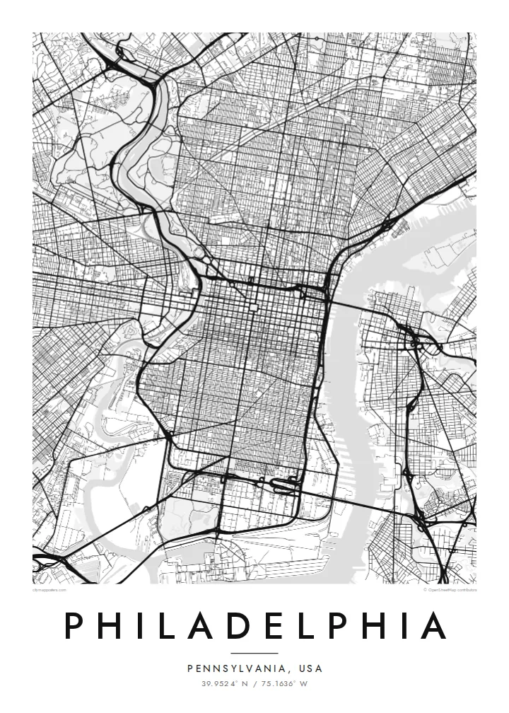
City Hall at the centre and four squares placed symmetrically around it are still visible as open spaces in the grid, a direct trace of the 1682 plan.
Pòster de mapa minimalista · Estats Units
39.9524° N / 75.1636° W
William Penn's orderly grid between two rivers, anchored by City Hall and cut by a single diagonal parkway.


Una ciutat, cinc ambients
Toca un estil per veure com queda a la paret. Tots els estils tenen el mateix preu, ja sigui imprès, emmarcat o en fitxers HD.
 Píxels reals · fitxer d'impressió de 24 × 36″
Nitidesa d'impressió
Aquesta és una retallada al 100% del fitxer d'impressió real. Cada pòster —imprès, emmarcat o descarregat— es genera als nostres servidors a 300 DPI, fins a 7,200 × 10,800 píxels, de manera que fins i tot els carrers més petits es vegin nítids en una impressió de 24 × 36″.
A la paret


El mapa
Philadelphia began as one of the first planned cities in America. In 1682 William Penn and his surveyor Thomas Holme laid out a rectangular grid stretching between the Delaware River on the east and the Schuylkill on the west, with five public squares placed at regular points. That plan still governs Center City, and it is easy to trace on a map today.
Broad Street and Market Street cross at the central square, where City Hall now stands, and four smaller squares, Rittenhouse, Washington, Logan and Franklin, sit in each quadrant. Near the Delaware, Independence Hall marks where the Declaration of Independence and the Constitution were debated and signed. Beyond the original grid, later neighbourhoods tilt and bend to follow old roads and the rivers.
The Benjamin Franklin Parkway breaks the pattern with a deliberate diagonal from City Hall to the Philadelphia Museum of Art, beyond which Fairmount Park follows the Schuylkill and the Wissahickon Creek for miles. A Philadelphia map poster frames all of this: the strict grid, the two rivers and the green valleys winding out toward the northwest.
City Hall at the centre and four squares placed symmetrically around it are still visible as open spaces in the grid, a direct trace of the 1682 plan.
The only major diagonal in Center City runs northwest from City Hall to the art museum, a wide boulevard modelled on Parisian avenues.
One of the largest urban park systems in the country follows the Schuylkill and Wissahickon Creek, drawing long green corridors through the northwestern neighbourhoods.
Fes-lo teu
Afegeix una data, un nom o una frase pròpia, i canvia l'estil, la mida o l'orientació.
La previsualització gratuïta és de baixa resolució i porta marca d'aigua. Les impressions i els fitxers HD es generen a 300 DPI, fins a 7,200 × 10,800 px, sense marca d'aigua.
Per què Philadelphia
Philadelphians tend to identify strongly with their neighbourhood, whether that is Fishtown, South Philly, Germantown or Rittenhouse. A map of the city lets you show the whole grid while pointing to one corner of it, a first apartment, a rowhouse or the place you met someone.
Personalise the title, the subtitle and the coordinates line with a street, a name or a date. Choose Classic black & white, Noir, Paper, Blueprint or Sand. Printed posters ship from partners in more than 30 countries, with an optional wooden frame.
Demana el pòster de Philadelphia| Mida d'impressió | Resolució | Fitxers |
|---|---|---|
| 30 × 40 cm11.8 × 15.7″ | 3,543 × 4,724 px | PNG · PDF |
| 29.7 × 42 cm (A3)11.7 × 16.5″ | 3,508 × 4,961 px | PNG · PDF |
| 42 × 59.4 cm (A2)16.5 × 23.4″ | 4,961 × 7,016 px | PNG · PDF |
| 45.7 × 61 cm18 × 24″ | 5,400 × 7,200 px | PNG · PDF |
| 50 × 70 cm19.7 × 27.6″ | 5,906 × 8,268 px | PNG · PDF |
| 61 × 91.4 cm24 × 36″ | 7,200 × 10,800 px | PNG · PDF |
Per comparar, la previsualització gratuïta fa 900 px d'amplada, porta marca d'aigua i està pensada per a pantalles. Els fitxers HD tenen fins a 8 vegades més resolució en cada direcció i s'imprimeixen perfectament a mida de pòster completa.
Tria un estil a la part superior de la pàgina i, després, selecciona Pòster imprès —una mida i, si vols, un marc— o Fitxers digitals HD. El pagament es fa en un sol pas i la pàgina de la teva comanda s'actualitza tan bon punt es confirma el pagament.
S'imprimeix en paper mat premium de 200 g/m² en una de sis mides, des de 30 × 40 cm fins a 24 × 36″. Els pòsters impresos comencen a $39, amb l'enviament inclòs.
Sí. Tria un marc de fusta massissa en negre, blanc, roure natural o fusta fosca. Inclou un vidre irrompible i està llest per penjar. Els pòsters emmarcats comencen a $99, amb l'enviament inclòs.
L'enviament és gratuït a més de 60 països. Cada pòster l'imprimeix el soci d'impressió més proper dels nostres, en més de 30 països, i normalment arriba en 3–7 dies feiners. Pots seguir l'estat i el seguiment a Les meves comandes. Alguns països triguen entre 2 i 5 setmanes, i si encara no enviem al teu, el web t'ho indica abans de pagar.
Envia'ns una foto dins dels 14 dies posteriors a la recepció i te'l tornarem a imprimir gratuïtament o et retornarem els diners.
Sí. A l'editor d'aquesta pàgina pots canviar el títol, el subtítol i la línia de coordenades pel que vulguis, i triar un estil i una mida. Les comandes impreses, emmarcades i digitals fan servir exactament el teu disseny.
Per $9 obtens fitxers PNG a 300 DPI i PDF llestos per imprimir en les sis mides, sense marca d'aigua, per imprimir on vulguis. Encara no ho tens clar? Descarrega abans una previsualització gratuïta amb marca d'aigua.
A prop
