Enniberg cliffs
The northern tip ends in an immense vertical cliff above the ocean. On the poster it marks the northernmost point of the Faroe Islands.
پوستر نقشه مینیمال · جزایر فارو
62.3356° N / 6.5003° W
The northernmost Faroe Island, a mountain ridge ending in one of Europe's highest sea cliffs


یک شهر، پنج حالوهوا
روی یک سبک ضربه بزنید تا آن را روی دیوار ببینید. همه سبکها قیمت یکسانی دارند — چاپی، قابشده یا فایلهای HD.
 پیکسل واقعی · فایل چاپی ۲۴ × ۳۶ اینچ
وضوح چاپی
این یک برش ۱۰۰٪ از فایل چاپی واقعی است. هر پوستر — چاپی، قابشده یا دانلودی — روی سرورهای ما با کیفیت 300 DPI و تا 7,200 × 10,800 پیکسل رندر میشود، به همین دلیل حتی ریزترین خیابانها هم روی چاپ ۲۴ × ۳۶ اینچ واضح میمانند.
روی دیوار


نقشه
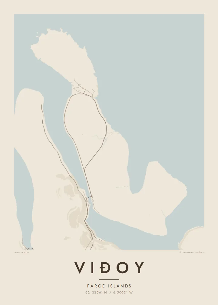
Viðoy is long and mountainous, with a steep spine running north to south and fjords on either side. On the map, its two villages sit where the land levels out. Hvannasund lies in the south, facing the narrow sound toward Borðoy, and Viðareiði lies in the north, on a low saddle between two bays. A road runs along the eastern shore and connects them.
At the island's northern tip stands Enniberg, a cliff that drops almost straight into the Atlantic from a height of several hundred metres. It is often listed among the tallest sea cliffs in Europe. Viðareiði is the northernmost village in the Faroes, and a causeway at the southern end links the island to Borðoy and the road network beyond.
A Viðoy map poster follows the island's ridge from the causeway to the cliffs. There is the coastal road, a village at each end and steep open ground between them. It is a portrait of the far north of the archipelago, where the land rises sharply before it ends.
The northern tip ends in an immense vertical cliff above the ocean. On the poster it marks the northernmost point of the Faroe Islands.
The northern village sits on a low neck of land between bays on either side. The coastlines come close together here, and the village fills the gap.
At Hvannasund, a causeway crosses the narrow sound to Borðoy. It is a short, straight line that connects the island to the rest of the road network.
شخصیسازی کنید
یک تاریخ، یک نام یا جملهای از خودتان اضافه کنید و سبک، اندازه یا جهت را تغییر دهید.
پیشنمایش رایگان کیفیت پایین و دارای واترمارک است. نسخههای چاپی و فایلهای HD با کیفیت 300 DPI، تا 7,200 × 10,800 پیکسل و بدون واترمارک رندر میشوند.
چرا Viðoy
People who have driven to the end of the road in Viðareiði or looked out toward Enniberg tend to remember Viðoy clearly. The long ridge outline suits tall formats, and the Classic black & white style shows the fjords with crisp contrast.
Personalise the title, subtitle and coordinates, and choose Classic black & white, Noir, Paper, Blueprint or Sand. Download the watermark-free HD files for $9, or order a printed poster on matte paper with an optional frame.
سفارش پوستر Viðoy| اندازه چاپ | وضوح | فایلها |
|---|---|---|
| 30 × 40 cm11.8 × 15.7″ | 3,543 × 4,724 px | PNG · PDF |
| 29.7 × 42 cm (A3)11.7 × 16.5″ | 3,508 × 4,961 px | PNG · PDF |
| 42 × 59.4 cm (A2)16.5 × 23.4″ | 4,961 × 7,016 px | PNG · PDF |
| 45.7 × 61 cm18 × 24″ | 5,400 × 7,200 px | PNG · PDF |
| 50 × 70 cm19.7 × 27.6″ | 5,906 × 8,268 px | PNG · PDF |
| 61 × 91.4 cm24 × 36″ | 7,200 × 10,800 px | PNG · PDF |
برای مقایسه، پیشنمایش رایگان ۹۰۰ پیکسل عرض دارد، واترمارکدار است و برای نمایش روی صفحه در نظر گرفته شده. فایلهای HD در هر جهت تا ۸ برابر وضوح بیشتری دارند و در اندازه کامل پوستر بهخوبی چاپ میشوند.
یک سبک را از بالای صفحه انتخاب کنید، سپس پوستر چاپی — یک اندازه و در صورت تمایل یک قاب — یا فایلهای دیجیتال HD را انتخاب کنید. پرداخت فقط یک مرحله دارد و صفحه سفارش شما به محض تکمیل پرداخت بهروزرسانی میشود.
روی کاغذ مات پرمیوم ۲۰۰ گرمی و در یکی از شش اندازه، از ۳۰ × ۴۰ سانتیمتر تا ۲۴ × ۳۶ اینچ، چاپ میشود. قیمت پوسترهای چاپی از $39 شروع میشود و هزینه ارسال هم شامل آن است.
بله. یک قاب چوب طبیعی به رنگ مشکی، سفید، بلوط طبیعی یا چوب تیره انتخاب کنید. این قاب با شیشه ضدشکست عرضه میشود و آماده نصب است. قیمت پوسترهای قابشده از $99 شروع میشود و هزینه ارسال هم شامل آن است.
ارسال به بیش از ۶۰ کشور رایگان است. هر پوستر را نزدیکترین شریک چاپ ما در بیش از ۳۰ کشور چاپ میکند و معمولاً ظرف ۳ تا ۷ روز کاری میرسد. وضعیت سفارش و کد رهگیری را در «سفارشهای من» میبینید. ارسال به چند کشور ۲ تا ۵ هفته طول میکشد و اگر هنوز به کشوری ارسال نداشته باشیم، سایت پیش از پرداخت به شما اطلاع میدهد.
ظرف ۱۴ روز از تحویل، یک عکس برای ما بفرستید تا آن را بهصورت رایگان دوباره چاپ کنیم یا هزینهتان را بازگردانیم.
بله. در ویرایشگر همین صفحه، عنوان، زیرعنوان و خط مختصات را به دلخواه تغییر دهید و یک سبک و اندازه انتخاب کنید. سفارشهای چاپی، قابشده و دیجیتال همگی دقیقاً از طرح شما استفاده میکنند.
با $9 فایلهای PNG با کیفیت 300 DPI و فایلهای PDF آماده چاپ را در هر شش اندازه، بدون واترمارک، دریافت میکنید تا هر جا خواستید چاپ کنید. هنوز مطمئن نیستید؟ ابتدا یک پیشنمایش رایگان با واترمارک دانلود کنید.
