Twin bays
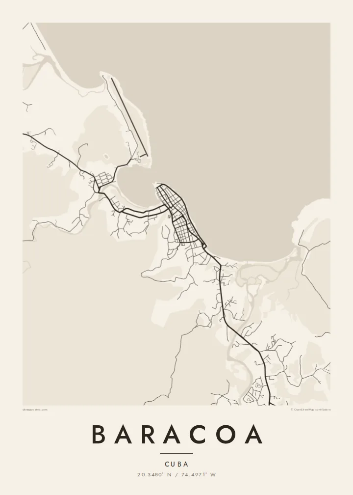
The town sits on a headland between two sheltered bays. Their curved shorelines give the northern and southern edges of the map a rounded shape that reads clearly even at small print sizes.
Minimalistiskt kortplakat · Kuba
20.3480° N / 74.4971° W
A small bayside grid on Cuba's far eastern tip, held between a curving seafront, river mouths and a flat-topped mountain




Ein býur, fimm stemningar
Trýst á ein stíl fyri at síggja hann á veggnum. Allir stílar kosta tað sama — sum prent, í ramma ella sum HD-fílur.
 Veruligar pixlar · 24 × 36″ prentfíla
Prentskarpt
Hetta er ein 100% útskurður av teirri veruligu prentfíluni. Hvør plakat — prentað, í ramma ella niðurhalað — verður gjørd á okkara ambætarum við 300 DPI, upp til 7,200 × 10,800 pixlar, so eisini tær smæstu gøtur halda seg skarpar á einum 24 × 36″ prenti.
Á veggnum


Kortið
Baracoa sits at the eastern end of Cuba, on a short stretch of coast where the land bends toward the Windward Passage. From above, the town is a compact block of streets on a low point between two bays. A seafront road follows the open shore to the north, and rivers come down from the forested hills behind to meet the sea on either side of the centre.
The town's place in history is simple to state. It was the first settlement the Spanish founded in Cuba, in 1511, and it served for a short time as the island's first capital. For centuries it could only be reached by sea. That changed in the 1960s with La Farola, the mountain road that climbs over the ranges from the south coast and appears on the map as a single thin winding line.
A Baracoa map poster shows how little room the town has between water and slope. The grid is dense and short. The bays give it a soft, rounded outline, and the countryside inland dissolves into thin lanes and river courses. Printed in black and white, the difference between the orderly centre and the loose, open land around it is the first thing you notice.
The town sits on a headland between two sheltered bays. Their curved shorelines give the northern and southern edges of the map a rounded shape that reads clearly even at small print sizes.
West of town rises El Yunque, a flat-topped mountain that sailors used as a landmark. On the map it shows up as open ground inland, with only a few tracks crossing it.
The mountain road that finally connected Baracoa to the rest of Cuba winds south through the hills. Where the street network ends, its switchbacks stand out as one looping line.
Ger tað til títt
Legg ein dag, eitt navn ella egnan tekst afturat, skift stíl, stødd ella snið.
Ókeypis forskoðanin er í lágari upploysing og hevur vatnmerki. Prent og HD-fílur verða gjørdar við 300 DPI, upp til 7,200 × 10,800 px, uttan vatnmerki.
Hví Baracoa
For many visitors, Baracoa is the part of Cuba that felt furthest from everything else: the end of a long road, a town facing the sea. A map of its few streets and two bays records that remoteness quietly, without needing a photograph.
You can set your own title, subtitle and coordinates line, which works well for a trip date or a family connection to Guantánamo Province. Choose Classic black & white, Noir, Paper, Blueprint or Sand. The file is $9 in HD, and printed posters ship from partners in more than 30 countries.
Panta Baracoa-plakatið| Prentstødd | Upploysn | Fílur |
|---|---|---|
| 30 × 40 cm (11.8 × 15.7″) | 3,543 × 4,724 px | PNG · PDF |
| 29.7 × 42 cm (A3, 11.7 × 16.5″) | 3,508 × 4,961 px | PNG · PDF |
| 42 × 59.4 cm (A2, 16.5 × 23.4″) | 4,961 × 7,016 px | PNG · PDF |
| 45.7 × 61 cm (18 × 24″) | 5,400 × 7,200 px | PNG · PDF |
| 50 × 70 cm (19.7 × 27.6″) | 5,906 × 8,268 px | PNG · PDF |
| 61 × 91.4 cm (24 × 36″) | 7,200 × 10,800 px | PNG · PDF |
Til samanberingar er ókeypis forsýningin 900 px breið, við vatnmerki og ætlað til skerm. HD-fílurnar hava upp til 8 ferðir so høga upploysn í hvørja átt og verða prentaðar reint í fullari plakatstødd.
Vel ein stíl ovast á síðuni, og vel síðani Prentað Plakat — eina stødd og, um tú vil, eina ramma — ella Digital HD-Fílur. Tað tekur bara eitt stig at ganga til kassa, og pantanarsíðan tín dagførist so skjótt sum gjaldið er gjøgnumført.
Tað verður prentað á 200 gsm matt kvalitetspappír í einari av seks støddum, frá 30 × 40 cm til 24 × 36″. Prentaðar plakatir byrja á {printFrom}, sending íroknað.
Ja. Vel eina ramma av massivum træi í svørtum, hvítum, natúrligum eik ella dekkum træi. Hon kemur við glassi, sum ikki brotnar, og er klár at hongja upp. Plakatir í ramma byrja á {framedFrom}, sending íroknað.
Sending er ókeypis um allan heim. Hvør plakat verður prentað hjá næsta prentsamstarvsfelaga okkara í 30+ londum og kemur vanliga fram innan 3–7 arbeiðsdagar. Tú kanst fylgja støðuni og sporing undir Mínar pantanir. Í nøkrum fáum londum tekur tað 2–5 vikur, og har sum vit ikki senda enn, sigur vevsíðan frá tí, áðrenn tú rindar.
Send okkum eitt mynd innan 14 dagar eftir móttøku, og vit prenta tað umaftur ókeypis ella endurgjalda tær.
Ja. Í ritlinum á hesi síðu kanst tú broyta heitið, undirheitið og koordinatlinjuna til hvat sum helst, og velja stíl og stødd. Prentaðar, ramma- og digitalar pantanir brúka allar sama honnun, sum tú hevur gjørt.
Fyri $9 fært tú 300 DPI PNG- og prentklárar PDF-fílur í øllum seks støddum, uttan vatnmerki, so tú kanst prenta hvar sum helst. Ikki vís enn? Halda niður eina ókeypis forskoðan við vatnmerki fyrst.
