The Eixample grid
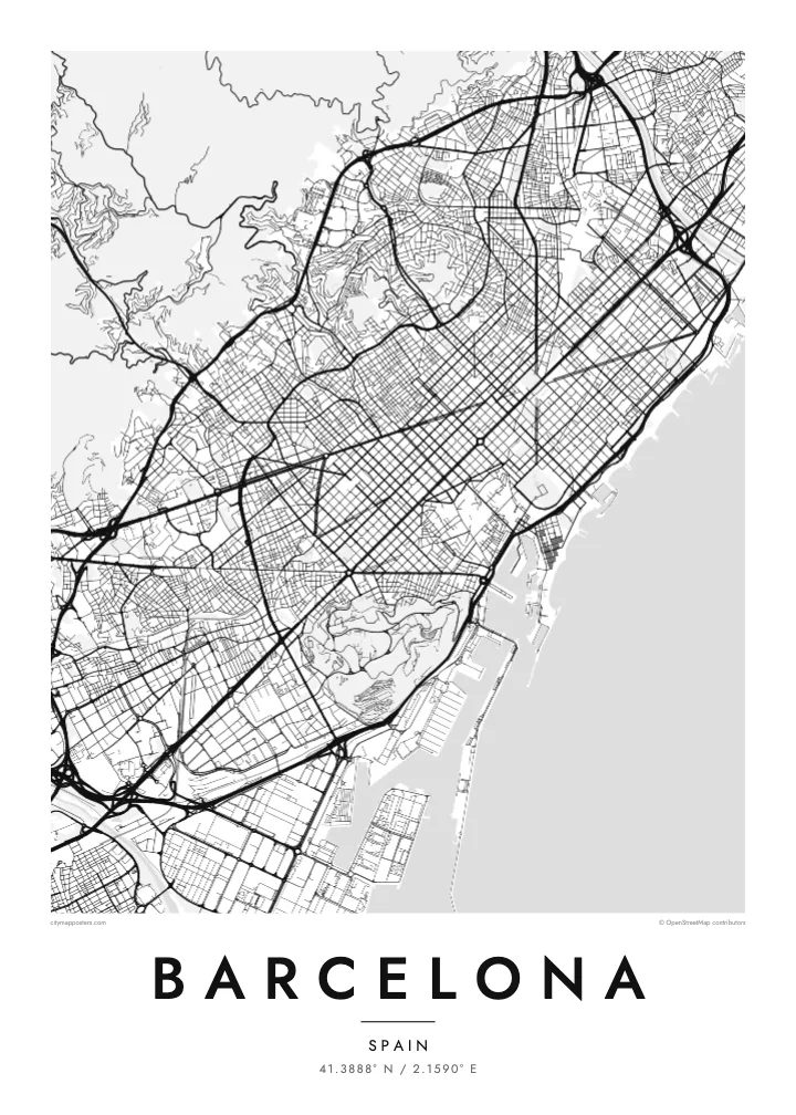
Cerdà's chamfered blocks form the most recognisable pattern on the map, each crossing opening into an octagon, a design meant to let in light and air and give traffic room to turn.
Minimalistiskt kortplakat · Spania
41.3888° N / 2.1590° E
A city pressed between mountains and sea, its famous grid of cut-corner blocks spreading in near-perfect rows across the plain.


Ein býur, fimm stemningar
Trýst á ein stíl fyri at síggja hann á veggnum. Allir stílar kosta tað sama — sum prent, í ramma ella sum HD-fílur.
 Veruligar pixlar · 24 × 36″ prentfíla
Prentskarpt
Hetta er ein 100% útskurður av teirri veruligu prentfíluni. Hvør plakat — prentað, í ramma ella niðurhalað — verður gjørd á okkara ambætarum við 300 DPI, upp til 7,200 × 10,800 pixlar, so eisini tær smæstu gøtur halda seg skarpar á einum 24 × 36″ prenti.
Á veggnum


Kortið
Barcelona is defined by its edges. The Mediterranean runs along one side, the ridge of Collserola closes off the other, and the Llobregat and Besòs rivers mark the limits to the south and north. Montjuïc rises straight from the port as a lone hill. Squeezed into that frame, the city had nowhere to grow but across the plain, and it did so with remarkable order.
That order is the Eixample, planned by Ildefons Cerdà in the mid nineteenth century. Its blocks are square with their corners cut off, so every crossing opens into a small octagonal plaza, and the pattern repeats almost without interruption. Avinguda Diagonal slices across it at an angle, and the Sagrada Família fills one block of the grid, still under construction more than a century after work began.
Below the grid, the old city is a tangle. The Gothic Quarter and El Raval crowd either side of La Rambla, a single straight promenade running down to the harbour, and the triangular fishing district of Barceloneta pokes out into the sea. On a Barcelona map poster the difference between the medieval core and the planned expansion is instantly legible.
Cerdà's chamfered blocks form the most recognisable pattern on the map, each crossing opening into an octagon, a design meant to let in light and air and give traffic room to turn.
As its name suggests, this avenue ignores the grid entirely, cutting across Barcelona at an angle from the western edge of the city to the sea near the Fòrum and giving the map its boldest line.
The hill above the port holds gardens, museums and the 1992 Olympic stadium, and appears on the map as a large irregular shape bordered by winding roads rather than straight streets.
Ger tað til títt
Legg ein dag, eitt navn ella egnan tekst afturat, skift stíl, stødd ella snið.
Ókeypis forskoðanin er í lágari upploysing og hevur vatnmerki. Prent og HD-fílur verða gjørdar við 300 DPI, upp til 7,200 × 10,800 px, uttan vatnmerki.
Hví Barcelona
Barcelona is a city many people discover young and never quite get over. A map of it can mark an exchange year, a summer spent walking the Eixample, a first home near the sea, or a trip taken with someone who later became family.
Make the poster yours with a title and a date, perhaps the name of your neighbourhood or the day you arrived. Then choose from five styles: Classic black & white shows the grid at its sharpest, while Noir, Paper, Blueprint and Sand change the mood without losing any of the detail.
Panta Barcelona-plakatið| Prentstødd | Upploysn | Fílur |
|---|---|---|
| 30 × 40 cm11.8 × 15.7″ | 3,543 × 4,724 px | PNG · PDF |
| 29.7 × 42 cm (A3)11.7 × 16.5″ | 3,508 × 4,961 px | PNG · PDF |
| 42 × 59.4 cm (A2)16.5 × 23.4″ | 4,961 × 7,016 px | PNG · PDF |
| 45.7 × 61 cm18 × 24″ | 5,400 × 7,200 px | PNG · PDF |
| 50 × 70 cm19.7 × 27.6″ | 5,906 × 8,268 px | PNG · PDF |
| 61 × 91.4 cm24 × 36″ | 7,200 × 10,800 px | PNG · PDF |
Til samanberingar er ókeypis forsýningin 900 px breið, við vatnmerki og ætlað til skerm. HD-fílurnar hava upp til 8 ferðir so høga upploysn í hvørja átt og verða prentaðar reint í fullari plakatstødd.
Vel ein stíl ovast á síðuni, og vel síðani Prentað Plakat — eina stødd og, um tú vil, eina ramma — ella Digital HD-Fílur. Tað tekur bara eitt stig at ganga til kassa, og pantanarsíðan tín dagførist so skjótt sum gjaldið er gjøgnumført.
Tað verður prentað á 200 gsm matt kvalitetspappír í einari av seks støddum, frá 30 × 40 cm til 24 × 36″. Prentaðar plakatir byrja á $39, sending íroknað.
Ja. Vel eina ramma av massivum træi í svørtum, hvítum, natúrligum eik ella dekkum træi. Hon kemur við glassi, sum ikki brotnar, og er klár at hongja upp. Plakatir í ramma byrja á $99, sending íroknað.
Flutningur er ókeypis til 60+ landa. Hvør plakat verður prentaður hjá tí prentfelaga okkara, sum er næstur, í 30+ londum, og kemur vanliga fram á 3–7 arbeiðsdøgum. Tú kanst fylgja støðuni og sporing undir Mínar pantanir. Fá lond taka 2–5 vikur, og har vit ikki enn senda, sigur vevsíðan tær frá, áðrenn tú rindar.
Send okkum eitt mynd innan 14 dagar eftir móttøku, og vit prenta tað umaftur ókeypis ella endurgjalda tær.
Ja. Í ritlinum á hesi síðu kanst tú broyta heitið, undirheitið og koordinatlinjuna til hvat sum helst, og velja stíl og stødd. Prentaðar, ramma- og digitalar pantanir brúka allar sama honnun, sum tú hevur gjørt.
Fyri $9 fært tú 300 DPI PNG- og prentklárar PDF-fílur í øllum seks støddum, uttan vatnmerki, so tú kanst prenta hvar sum helst. Ikki vís enn? Halda niður eina ókeypis forskoðan við vatnmerki fyrst.
