The beach
A long, straight stretch of sand runs along the coast. On the poster it forms a strong edge where the street pattern stops at the sea.
Minimalistiskt kortplakat · Spania
41.2779° N / 1.9703° E
A Barcelona coastal town stretched along a long sandy beach, pine woods and the edge of the Garraf hills


Ein býur, fimm stemningar
Trýst á ein stíl fyri at síggja hann á veggnum. Allir stílar kosta tað sama — sum prent, í ramma ella sum HD-fílur.
 Veruligar pixlar · 24 × 36″ prentfíla
Prentskarpt
Hetta er ein 100% útskurður av teirri veruligu prentfíluni. Hvør plakat — prentað, í ramma ella niðurhalað — verður gjørd á okkara ambætarum við 300 DPI, upp til 7,200 × 10,800 pixlar, so eisini tær smæstu gøtur halda seg skarpar á einum 24 × 36″ prenti.
Á veggnum


Kortið
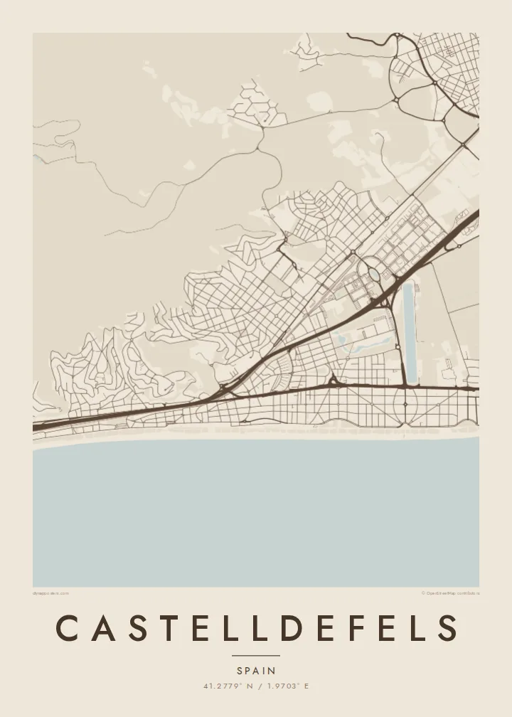
Castelldefels lies on the Mediterranean coast south-west of Barcelona, where the flat Llobregat delta meets the limestone hills of the Garraf massif. Its map is long and narrow. A straight beach runs for several kilometres, with a ribbon of streets and houses behind it, and the town centre sits a little inland around the old castle on its hill.
Several parallel lines divide the town: the seafront, the railway, and the main roads toward Barcelona and Sitges. Between them are residential grids and areas of pine woodland. A long rowing canal cuts a very straight line across the delta side of the town. To the west, the Garraf hills rise abruptly, and streets begin to curve and climb.
Castelldefels grew from a small village into a popular seaside suburb, and the castle that gives it its name still stands above the centre. A Castelldefels map poster captures that layered structure: sand, rail, roads and hills lying next to one another in bands, with the Mediterranean running along one edge.
A long, straight stretch of sand runs along the coast. On the poster it forms a strong edge where the street pattern stops at the sea.
A long straight water channel crosses the flat land near the delta. Its perfect line stands out against the curves around it.
To the west, the town meets steep limestone slopes. Streets start to wind here, giving that end of the map a very different texture.
Ger tað til títt
Legg ein dag, eitt navn ella egnan tekst afturat, skift stíl, stødd ella snið.
Ókeypis forskoðanin er í lágari upploysing og hevur vatnmerki. Prent og HD-fílur verða gjørdar við 300 DPI, upp til 7,200 × 10,800 px, uttan vatnmerki.
Hví Castelldefels
Castelldefels appeals to people who live near Barcelona, to those who have spent summers on its beach, and to anyone who has studied or worked there. Its long coastline makes an elegant horizontal composition.
Edit the title and subtitle, adding a date or a street for example, and adjust the coordinates line. There are five styles to choose from: Classic black and white, Noir, Paper, Blueprint and Sand.
Panta Castelldefels-plakatið| Prentstødd | Upploysn | Fílur |
|---|---|---|
| 30 × 40 cm11.8 × 15.7″ | 3,543 × 4,724 px | PNG · PDF |
| 29.7 × 42 cm (A3)11.7 × 16.5″ | 3,508 × 4,961 px | PNG · PDF |
| 42 × 59.4 cm (A2)16.5 × 23.4″ | 4,961 × 7,016 px | PNG · PDF |
| 45.7 × 61 cm18 × 24″ | 5,400 × 7,200 px | PNG · PDF |
| 50 × 70 cm19.7 × 27.6″ | 5,906 × 8,268 px | PNG · PDF |
| 61 × 91.4 cm24 × 36″ | 7,200 × 10,800 px | PNG · PDF |
Til samanberingar er ókeypis forsýningin 900 px breið, við vatnmerki og ætlað til skerm. HD-fílurnar hava upp til 8 ferðir so høga upploysn í hvørja átt og verða prentaðar reint í fullari plakatstødd.
Vel ein stíl ovast á síðuni, og vel síðani Prentað Plakat — eina stødd og, um tú vil, eina ramma — ella Digital HD-Fílur. Tað tekur bara eitt stig at ganga til kassa, og pantanarsíðan tín dagførist so skjótt sum gjaldið er gjøgnumført.
Tað verður prentað á 200 gsm matt kvalitetspappír í einari av seks støddum, frá 30 × 40 cm til 24 × 36″. Prentaðar plakatir byrja á $39, sending íroknað.
Ja. Vel eina ramma av massivum træi í svørtum, hvítum, natúrligum eik ella dekkum træi. Hon kemur við glassi, sum ikki brotnar, og er klár at hongja upp. Plakatir í ramma byrja á $99, sending íroknað.
Flutningur er ókeypis til 60+ landa. Hvør plakat verður prentaður hjá tí prentfelaga okkara, sum er næstur, í 30+ londum, og kemur vanliga fram á 3–7 arbeiðsdøgum. Tú kanst fylgja støðuni og sporing undir Mínar pantanir. Fá lond taka 2–5 vikur, og har vit ikki enn senda, sigur vevsíðan tær frá, áðrenn tú rindar.
Send okkum eitt mynd innan 14 dagar eftir móttøku, og vit prenta tað umaftur ókeypis ella endurgjalda tær.
Ja. Í ritlinum á hesi síðu kanst tú broyta heitið, undirheitið og koordinatlinjuna til hvat sum helst, og velja stíl og stødd. Prentaðar, ramma- og digitalar pantanir brúka allar sama honnun, sum tú hevur gjørt.
Fyri $9 fært tú 300 DPI PNG- og prentklárar PDF-fílur í øllum seks støddum, uttan vatnmerki, so tú kanst prenta hvar sum helst. Ikki vís enn? Halda niður eina ókeypis forskoðan við vatnmerki fyrst.
