Central grid
The old core follows the familiar Mexican plan of square blocks around a plaza and parish church, printing as a dense, orderly centre that the rest of the map radiates from.
Minimalistiskt kortplakat · Meksiko
19.5885° N / 102.4733° W
A compact valley town where a tight colonial grid gives way to cane fields, orchards and the volcanic slopes of western Michoacán


Ein býur, fimm stemningar
Trýst á ein stíl fyri at síggja hann á veggnum. Allir stílar kosta tað sama — sum prent, í ramma ella sum HD-fílur.
 Veruligar pixlar · 24 × 36″ prentfíla
Prentskarpt
Hetta er ein 100% útskurður av teirri veruligu prentfíluni. Hvør plakat — prentað, í ramma ella niðurhalað — verður gjørd á okkara ambætarum við 300 DPI, upp til 7,200 × 10,800 pixlar, so eisini tær smæstu gøtur halda seg skarpar á einum 24 × 36″ prenti.
Á veggnum


Kortið
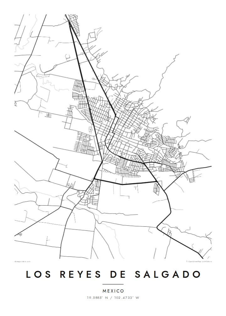
Los Reyes de Salgado sits in a green valley in western Michoacán, where the highland plateau begins to break toward lower, warmer country. From above, the town is a dense cluster of short blocks around a central plaza. Beyond it the streets quickly thin out into farm tracks, irrigation lines and field boundaries that cover the valley floor in a patchwork of long rectangles.
The surrounding municipality is known for growing sugar cane, and in recent decades for berries, especially blackberries grown for export. On a map, farming shows up as geometry more than as detail: straight access roads, regular plots and small clusters of buildings scattered across open ground. To the east the terrain rises toward the volcanic high country around Tancítaro, and the contour of the land shapes where the roads can run.
A Los Reyes de Salgado map poster shows that contrast clearly. The town centre prints as a tight knot of black lines, while the edges loosen into a sparse web of rural roads. The result is quiet and balanced, a record of a working agricultural town seen from the air, with the town grid holding the middle of the frame and the open valley around it.
The old core follows the familiar Mexican plan of square blocks around a plaza and parish church, printing as a dense, orderly centre that the rest of the map radiates from.
Around the town, cane and berry fields form long rectangular parcels crossed by straight tracks, giving the outer map a calm, ruled texture that contrasts with the compact centre.
Toward the east the land climbs into volcanic high country, and the roads start to bend and switch back, a change of rhythm you can see even in a minimal black-and-white print.
Ger tað til títt
Legg ein dag, eitt navn ella egnan tekst afturat, skift stíl, stødd ella snið.
Ókeypis forskoðanin er í lágari upploysing og hevur vatnmerki. Prent og HD-fílur verða gjørdar við 300 DPI, upp til 7,200 × 10,800 px, uttan vatnmerki.
Hví Los Reyes de Salgado
For people from Los Reyes, or with family roots there, this map is a direct reminder of home: the plaza, the streets walked every day, and the fields that sustain the region. It works well in a kitchen or hallway, where a familiar plan is recognised at a glance.
You can add your own title, a subtitle such as a family name or a year, and a coordinates line, then choose from five styles: Classic black & white, Noir, Paper, Blueprint or Sand. It is available as a $9 digital HD download or as a printed matte poster, with an optional wooden frame.
Panta Los Reyes de Salgado-plakatið| Prentstødd | Upploysn | Fílur |
|---|---|---|
| 30 × 40 cm11.8 × 15.7″ | 3,543 × 4,724 px | PNG · PDF |
| 29.7 × 42 cm (A3)11.7 × 16.5″ | 3,508 × 4,961 px | PNG · PDF |
| 42 × 59.4 cm (A2)16.5 × 23.4″ | 4,961 × 7,016 px | PNG · PDF |
| 45.7 × 61 cm18 × 24″ | 5,400 × 7,200 px | PNG · PDF |
| 50 × 70 cm19.7 × 27.6″ | 5,906 × 8,268 px | PNG · PDF |
| 61 × 91.4 cm24 × 36″ | 7,200 × 10,800 px | PNG · PDF |
Til samanberingar er ókeypis forsýningin 900 px breið, við vatnmerki og ætlað til skerm. HD-fílurnar hava upp til 8 ferðir so høga upploysn í hvørja átt og verða prentaðar reint í fullari plakatstødd.
Vel ein stíl ovast á síðuni, og vel síðani Prentað Plakat — eina stødd og, um tú vil, eina ramma — ella Digital HD-Fílur. Tað tekur bara eitt stig at ganga til kassa, og pantanarsíðan tín dagførist so skjótt sum gjaldið er gjøgnumført.
Tað verður prentað á 200 gsm matt kvalitetspappír í einari av seks støddum, frá 30 × 40 cm til 24 × 36″. Prentaðar plakatir byrja á $39, sending íroknað.
Ja. Vel eina ramma av massivum træi í svørtum, hvítum, natúrligum eik ella dekkum træi. Hon kemur við glassi, sum ikki brotnar, og er klár at hongja upp. Plakatir í ramma byrja á $99, sending íroknað.
Flutningur er ókeypis til 60+ landa. Hvør plakat verður prentaður hjá tí prentfelaga okkara, sum er næstur, í 30+ londum, og kemur vanliga fram á 3–7 arbeiðsdøgum. Tú kanst fylgja støðuni og sporing undir Mínar pantanir. Fá lond taka 2–5 vikur, og har vit ikki enn senda, sigur vevsíðan tær frá, áðrenn tú rindar.
Send okkum eitt mynd innan 14 dagar eftir móttøku, og vit prenta tað umaftur ókeypis ella endurgjalda tær.
Ja. Í ritlinum á hesi síðu kanst tú broyta heitið, undirheitið og koordinatlinjuna til hvat sum helst, og velja stíl og stødd. Prentaðar, ramma- og digitalar pantanir brúka allar sama honnun, sum tú hevur gjørt.
Fyri $9 fært tú 300 DPI PNG- og prentklárar PDF-fílur í øllum seks støddum, uttan vatnmerki, so tú kanst prenta hvar sum helst. Ikki vís enn? Halda niður eina ókeypis forskoðan við vatnmerki fyrst.
