The Presqu'île
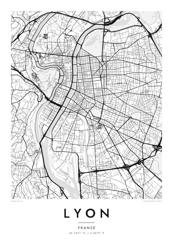
The peninsula between the Rhône and Saône holds a dense, elongated centre with Place Bellecour at its heart, framed on both sides by quays and a steady rhythm of bridges.
Minimalistiskt kortplakat · Frakland
45.7491° N / 4.8479° E
Two rivers, two hills and a narrow peninsula between them: the Rhône and Saône give Lyon one of France's clearest city maps.


Ein býur, fimm stemningar
Trýst á ein stíl fyri at síggja hann á veggnum. Allir stílar kosta tað sama — sum prent, í ramma ella sum HD-fílur.
 Veruligar pixlar · 24 × 36″ prentfíla
Prentskarpt
Hetta er ein 100% útskurður av teirri veruligu prentfíluni. Hvør plakat — prentað, í ramma ella niðurhalað — verður gjørd á okkara ambætarum við 300 DPI, upp til 7,200 × 10,800 pixlar, so eisini tær smæstu gøtur halda seg skarpar á einum 24 × 36″ prenti.
Á veggnum


Kortið
Lyon is built where the Saône meets the Rhône, and the two rivers give the city an unusually legible shape. Between them runs the Presqu'île, a long, narrow peninsula that holds the historic commercial centre, Place Bellecour and the Hôtel de Ville. At its southern tip, the former docklands of Confluence have been rebuilt as a modern district where the two rivers meet.
West of the Saône, Fourvière hill rises steeply above Vieux Lyon. Its basilica can be seen from across the city, and its slopes hold the remains of Roman Lugdunum, once a capital of Gaul. North of the Presqu'île, the Croix-Rousse hill was home to the silk weavers, whose covered passageways, the traboules, still run through buildings and courtyards. The historic centre is a UNESCO World Heritage Site.
East of the Rhône the city opens into a broader grid, and Parc de la Tête d'Or, one of the largest urban parks in France, curves along the riverbank. A Lyon map poster shows all of this at once: bridges linking the banks, hills pressing against the old town and the orderly east bank spreading toward the plain.
The peninsula between the Rhône and Saône holds a dense, elongated centre with Place Bellecour at its heart, framed on both sides by quays and a steady rhythm of bridges.
On the west bank, the medieval streets of Vieux Lyon are squeezed between the Saône and the steep slope of Fourvière, where winding roads climb to the basilica.
The large park on the left bank of the Rhône shows as a broad open area with a lake, a clear green anchor against the regular blocks of the east side.
Ger tað til títt
Legg ein dag, eitt navn ella egnan tekst afturat, skift stíl, stødd ella snið.
Ókeypis forskoðanin er í lágari upploysing og hevur vatnmerki. Prent og HD-fílur verða gjørdar við 300 DPI, upp til 7,200 × 10,800 px, uttan vatnmerki.
Hví Lyon
People come to Lyon to study, eat and work, and many stay longer than planned. A map of its rivers and hills is a quiet reminder of an apartment on the Croix-Rousse slope, a café on the Presqu'île or a first job near Part-Dieu station.
Set the title and subtitle to anything you like, from an arrondissement to the day you arrived, and edit the coordinates line. Each of the five styles, Classic black & white, Noir, Paper, Blueprint and Sand, shows Lyon's rivers differently. HD files cost $9, and prints ship from partners in 30+ countries.
Panta Lyon-plakatið| Prentstødd | Upploysn | Fílur |
|---|---|---|
| 30 × 40 cm (11.8 × 15.7″) | 3,543 × 4,724 px | PNG · PDF |
| 29.7 × 42 cm (A3, 11.7 × 16.5″) | 3,508 × 4,961 px | PNG · PDF |
| 42 × 59.4 cm (A2, 16.5 × 23.4″) | 4,961 × 7,016 px | PNG · PDF |
| 45.7 × 61 cm (18 × 24″) | 5,400 × 7,200 px | PNG · PDF |
| 50 × 70 cm (19.7 × 27.6″) | 5,906 × 8,268 px | PNG · PDF |
| 61 × 91.4 cm (24 × 36″) | 7,200 × 10,800 px | PNG · PDF |
Til samanberingar er ókeypis forsýningin 900 px breið, við vatnmerki og ætlað til skerm. HD-fílurnar hava upp til 8 ferðir so høga upploysn í hvørja átt og verða prentaðar reint í fullari plakatstødd.
Vel ein stíl ovast á síðuni, og vel síðani Prentað Plakat — eina stødd og, um tú vil, eina ramma — ella Digital HD-Fílur. Tað tekur bara eitt stig at ganga til kassa, og pantanarsíðan tín dagførist so skjótt sum gjaldið er gjøgnumført.
Tað verður prentað á 200 gsm matt kvalitetspappír í einari av seks støddum, frá 30 × 40 cm til 24 × 36″. Prentaðar plakatir byrja á $39, sending íroknað.
Ja. Vel eina ramma av massivum træi í svørtum, hvítum, natúrligum eik ella dekkum træi. Hon kemur við glassi, sum ikki brotnar, og er klár at hongja upp. Plakatir í ramma byrja á $99, sending íroknað.
Sending er ókeypis um allan heim. Hvør plakat verður prentað hjá næsta prentsamstarvsfelaga okkara í 30+ londum og kemur vanliga fram innan 3–7 arbeiðsdagar. Tú kanst fylgja støðuni og sporing undir Mínar pantanir. Í nøkrum fáum londum tekur tað 2–5 vikur, og har sum vit ikki senda enn, sigur vevsíðan frá tí, áðrenn tú rindar.
Send okkum eitt mynd innan 14 dagar eftir móttøku, og vit prenta tað umaftur ókeypis ella endurgjalda tær.
Ja. Í ritlinum á hesi síðu kanst tú broyta heitið, undirheitið og koordinatlinjuna til hvat sum helst, og velja stíl og stødd. Prentaðar, ramma- og digitalar pantanir brúka allar sama honnun, sum tú hevur gjørt.
Fyri $9 fært tú 300 DPI PNG- og prentklárar PDF-fílur í øllum seks støddum, uttan vatnmerki, so tú kanst prenta hvar sum helst. Ikki vís enn? Halda niður eina ókeypis forskoðan við vatnmerki fyrst.
