Temple-centred core
The older town gathers around the Nagaraja Temple and nearby market streets. It is the densest part of the map, and main roads spread out from it.
Minimalistiskt kortplakat · India
8.1790° N / 77.4323° E
India's southern tip, where a temple town meets paddy fields, coconut groves and the last hills of the Western Ghats



Ein býur, fimm stemningar
Trýst á ein stíl fyri at síggja hann á veggnum. Allir stílar kosta tað sama — sum prent, í ramma ella sum HD-fílur.
 Veruligar pixlar · 24 × 36″ prentfíla
Prentskarpt
Hetta er ein 100% útskurður av teirri veruligu prentfíluni. Hvør plakat — prentað, í ramma ella niðurhalað — verður gjørd á okkara ambætarum við 300 DPI, upp til 7,200 × 10,800 pixlar, so eisini tær smæstu gøtur halda seg skarpar á einum 24 × 36″ prenti.
Á veggnum


Kortið
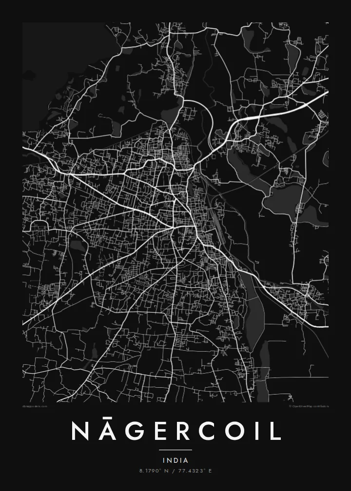
Nāgercoil is the administrative centre of Kanyakumari district, near the southern end of the Indian peninsula. The town sits in a green basin with the last ridges of the Western Ghats rising to the north and west. On a map, a compact core of busy streets gives way quickly to paddy fields, tanks and coconut plantations, which fill the gaps between neighbouring villages.
The name is linked to the Nagaraja Temple, dedicated to the serpent king, which remains a central landmark. Main roads leave the centre toward Thiruvananthapuram in the northwest, Tirunelveli in the northeast and Kanyakumari, the cape where three seas meet, a short drive to the south. Irrigation channels and water tanks appear across the surrounding plain as small blue shapes.
A Nāgercoil map poster shows a town closely bound to its landscape. Streets fan out from the old centre, water tanks are scattered through the fields, and the terrain begins to rise toward the hills. It is a map of the far south, where the continent narrows and runs out.
The older town gathers around the Nagaraja Temple and nearby market streets. It is the densest part of the map, and main roads spread out from it.
Irrigation tanks and channels dot the surrounding plain. On the poster they appear as scattered, rounded shapes among the fields and roads.
Main roads lead south toward Kanyakumari and north toward the Kerala border. They make clear lines through the green basin at the tip of India.
Ger tað til títt
Legg ein dag, eitt navn ella egnan tekst afturat, skift stíl, stødd ella snið.
Ókeypis forskoðanin er í lágari upploysing og hevur vatnmerki. Prent og HD-fílur verða gjørdar við 300 DPI, upp til 7,200 × 10,800 px, uttan vatnmerki.
Hví Nāgercoil
Nāgercoil is home for many people who work in Kerala, Chennai or the Gulf. A poster of its streets and tanks is a quiet link to the southern tip, and it makes a good wedding or housewarming gift.
Write your own title and subtitle, such as a family name or a date, and adjust the coordinates. Then pick Classic black & white, Noir, Paper, Blueprint or Sand.
Panta Nāgercoil-plakatið| Prentstødd | Upploysn | Fílur |
|---|---|---|
| 30 × 40 cm11.8 × 15.7″ | 3,543 × 4,724 px | PNG · PDF |
| 29.7 × 42 cm (A3)11.7 × 16.5″ | 3,508 × 4,961 px | PNG · PDF |
| 42 × 59.4 cm (A2)16.5 × 23.4″ | 4,961 × 7,016 px | PNG · PDF |
| 45.7 × 61 cm18 × 24″ | 5,400 × 7,200 px | PNG · PDF |
| 50 × 70 cm19.7 × 27.6″ | 5,906 × 8,268 px | PNG · PDF |
| 61 × 91.4 cm24 × 36″ | 7,200 × 10,800 px | PNG · PDF |
Til samanberingar er ókeypis forsýningin 900 px breið, við vatnmerki og ætlað til skerm. HD-fílurnar hava upp til 8 ferðir so høga upploysn í hvørja átt og verða prentaðar reint í fullari plakatstødd.
Vel ein stíl ovast á síðuni, og vel síðani Prentað Plakat — eina stødd og, um tú vil, eina ramma — ella Digital HD-Fílur. Tað tekur bara eitt stig at ganga til kassa, og pantanarsíðan tín dagførist so skjótt sum gjaldið er gjøgnumført.
Tað verður prentað á 200 gsm matt kvalitetspappír í einari av seks støddum, frá 30 × 40 cm til 24 × 36″. Prentaðar plakatir byrja á $39, sending íroknað.
Ja. Vel eina ramma av massivum træi í svørtum, hvítum, natúrligum eik ella dekkum træi. Hon kemur við glassi, sum ikki brotnar, og er klár at hongja upp. Plakatir í ramma byrja á $99, sending íroknað.
Flutningur er ókeypis til 60+ landa. Hvør plakat verður prentaður hjá tí prentfelaga okkara, sum er næstur, í 30+ londum, og kemur vanliga fram á 3–7 arbeiðsdøgum. Tú kanst fylgja støðuni og sporing undir Mínar pantanir. Fá lond taka 2–5 vikur, og har vit ikki enn senda, sigur vevsíðan tær frá, áðrenn tú rindar.
Send okkum eitt mynd innan 14 dagar eftir móttøku, og vit prenta tað umaftur ókeypis ella endurgjalda tær.
Ja. Í ritlinum á hesi síðu kanst tú broyta heitið, undirheitið og koordinatlinjuna til hvat sum helst, og velja stíl og stødd. Prentaðar, ramma- og digitalar pantanir brúka allar sama honnun, sum tú hevur gjørt.
Fyri $9 fært tú 300 DPI PNG- og prentklárar PDF-fílur í øllum seks støddum, uttan vatnmerki, so tú kanst prenta hvar sum helst. Ikki vís enn? Halda niður eina ókeypis forskoðan við vatnmerki fyrst.
