Peninsula outline
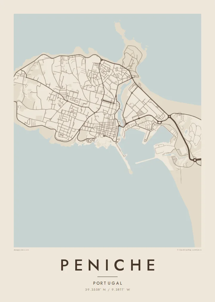
The headland is almost entirely surrounded by the Atlantic, making its coastline the most powerful shape on the map.
Minimalistiskt kortplakat · Portugal
39.3558° N / 9.3811° W
A fishing town on a rocky peninsula, almost surrounded by the Atlantic, with a fortress and harbour facing the mainland.


Ein býur, fimm stemningar
Trýst á ein stíl fyri at síggja hann á veggnum. Allir stílar kosta tað sama — sum prent, í ramma ella sum HD-fílur.
 Veruligar pixlar · 24 × 36″ prentfíla
Prentskarpt
Hetta er ein 100% útskurður av teirri veruligu prentfíluni. Hvør plakat — prentað, í ramma ella niðurhalað — verður gjørd á okkara ambætarum við 300 DPI, upp til 7,200 × 10,800 pixlar, so eisini tær smæstu gøtur halda seg skarpar á einum 24 × 36″ prenti.
Á veggnum


Kortið
Peniche occupies a rugged headland on Portugal's west coast, and on a map it is unmistakable: a rounded block of land joined to the mainland by a low isthmus. The old town and harbour sit on the southern side, facing sheltered water, while the northern and western shores are cliffs and rocky coves. At the western tip lies Cabo Carvoeiro, and further out the Berlengas islands.
Peniche was once an island, gradually connected to the mainland by sand and sediment. Its sixteenth-century fortress later served as a political prison under the Estado Novo regime, famously the scene of an escape by opposition leader Álvaro Cunhal in 1960, and now houses a museum of resistance and freedom. Today the town is also known for surfing, especially at Supertubos beach.
A Peniche map poster shows this dramatic geography in a single frame. The peninsula's outline, the walls of the old town, the harbour basin and the beaches along the isthmus create a composition with water on almost every side. It is one of those places where the coastline alone tells the story.
The headland is almost entirely surrounded by the Atlantic, making its coastline the most powerful shape on the map.
On the southern shore, the fortress and fishing harbour face the mainland, with the old town packed tightly behind them.
Long sandy beaches, including Supertubos, run along the low neck of land joining Peniche to the rest of Portugal.
Ger tað til títt
Legg ein dag, eitt navn ella egnan tekst afturat, skift stíl, stødd ella snið.
Ókeypis forskoðanin er í lágari upploysing og hevur vatnmerki. Prent og HD-fílur verða gjørdar við 300 DPI, upp til 7,200 × 10,800 px, uttan vatnmerki.
Hví Peniche
Surfers, sailors and anyone who has watched the sun set over Cabo Carvoeiro will understand the appeal. Peniche's coastline makes a bold, clear image that works in any room.
You can add a title, a subtitle such as the date of a trip, and coordinates, then choose Classic black & white, Noir, Paper, Blueprint or Sand. Six print sizes come as PNG and PDF for $9.
Panta Peniche-plakatið| Prentstødd | Upploysn | Fílur |
|---|---|---|
| 30 × 40 cm (11.8 × 15.7″) | 3,543 × 4,724 px | PNG · PDF |
| 29.7 × 42 cm (A3, 11.7 × 16.5″) | 3,508 × 4,961 px | PNG · PDF |
| 42 × 59.4 cm (A2, 16.5 × 23.4″) | 4,961 × 7,016 px | PNG · PDF |
| 45.7 × 61 cm (18 × 24″) | 5,400 × 7,200 px | PNG · PDF |
| 50 × 70 cm (19.7 × 27.6″) | 5,906 × 8,268 px | PNG · PDF |
| 61 × 91.4 cm (24 × 36″) | 7,200 × 10,800 px | PNG · PDF |
Til samanberingar er ókeypis forsýningin 900 px breið, við vatnmerki og ætlað til skerm. HD-fílurnar hava upp til 8 ferðir so høga upploysn í hvørja átt og verða prentaðar reint í fullari plakatstødd.
Vel ein stíl ovast á síðuni, og vel síðani Prentað Plakat — eina stødd og, um tú vil, eina ramma — ella Digital HD-Fílur. Tað tekur bara eitt stig at ganga til kassa, og pantanarsíðan tín dagførist so skjótt sum gjaldið er gjøgnumført.
Tað verður prentað á 200 gsm matt kvalitetspappír í einari av seks støddum, frá 30 × 40 cm til 24 × 36″. Prentaðar plakatir byrja á $39, sending íroknað.
Ja. Vel eina ramma av massivum træi í svørtum, hvítum, natúrligum eik ella dekkum træi. Hon kemur við glassi, sum ikki brotnar, og er klár at hongja upp. Plakatir í ramma byrja á $99, sending íroknað.
Sending er ókeypis um allan heim. Hvør plakat verður prentað hjá næsta prentsamstarvsfelaga okkara í 30+ londum og kemur vanliga fram innan 3–7 arbeiðsdagar. Tú kanst fylgja støðuni og sporing undir Mínar pantanir. Í nøkrum fáum londum tekur tað 2–5 vikur, og har sum vit ikki senda enn, sigur vevsíðan frá tí, áðrenn tú rindar.
Send okkum eitt mynd innan 14 dagar eftir móttøku, og vit prenta tað umaftur ókeypis ella endurgjalda tær.
Ja. Í ritlinum á hesi síðu kanst tú broyta heitið, undirheitið og koordinatlinjuna til hvat sum helst, og velja stíl og stødd. Prentaðar, ramma- og digitalar pantanir brúka allar sama honnun, sum tú hevur gjørt.
Fyri $9 fært tú 300 DPI PNG- og prentklárar PDF-fílur í øllum seks støddum, uttan vatnmerki, so tú kanst prenta hvar sum helst. Ikki vís enn? Halda niður eina ókeypis forskoðan við vatnmerki fyrst.
