Central square
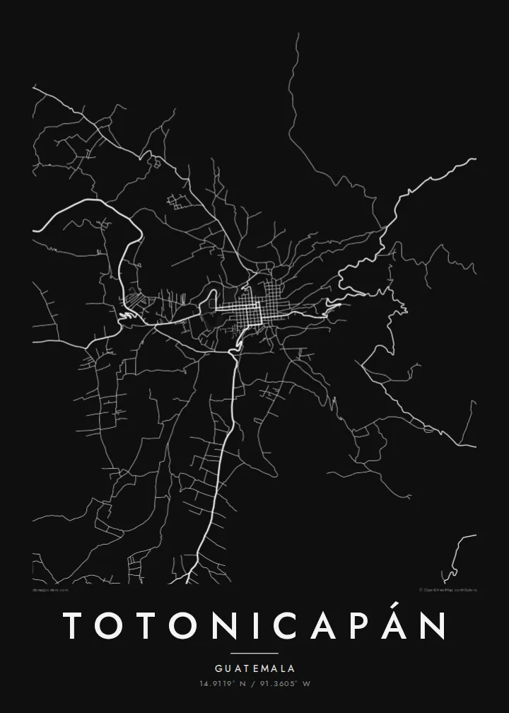
The main plaza anchors the older part of town, with a tight block pattern around it that forms the densest cluster of lines on the poster.
Affiche carte minimaliste · Guatemala
14.9119° N / 91.3605° W
A highland town climbing the sides of a narrow valley, its streets bending with the slopes of the western Guatemalan mountains.



Une ville, cinq ambiances
Touchez un style pour le voir sur le mur. Tous les styles coûtent le même prix — imprimé, encadré ou en fichiers HD.
 Pixels réels · fichier d'impression 24 × 36″
Netteté d'impression
Ceci est un recadrage à 100 % du fichier d'impression réel. Chaque poster — imprimé, encadré ou téléchargé — est généré sur nos serveurs à 300 DPI, jusqu'à 7,200 × 10,800 pixels, pour que même les plus petites ruelles restent nettes sur un tirage 24 × 36″.
Au mur


La carte
Totonicapán lies high in the western highlands of Guatemala, at roughly 2,500 metres, and is the capital of the department of the same name. The town fills a valley floor and spreads up the surrounding slopes. Its map therefore combines a compact centre around the main square with streets that twist and switch back where the ground rises.
Most of the population is K'iche' Maya. Totonicapán is known for a strong tradition of communal self-government through the 48 Cantones, and for crafts such as weaving, pottery and carved wooden masks. The pine forests on the hills above town have long been managed by local communities. On the map they frame the settlement as open space around a dense core.
A Totonicapán map poster captures a town shaped more by terrain than by planning. Around the centre the streets are close and regular. Further out they follow ridges and gullies, breaking into irregular lines that give the print texture and movement. For a small mountain town, the result is surprisingly graphic.
The main plaza anchors the older part of town, with a tight block pattern around it that forms the densest cluster of lines on the poster.
Beyond the centre, roads curve and zigzag with the terrain, a clear sign on the map of how steep the valley sides are.
The hills around the town, covered in communally managed pine forest, appear as open areas that let the compact urban shape stand out.
Personnalisez-la
Ajoutez une date, un nom ou votre propre phrase, changez de style, de format ou d'orientation.
L'aperçu gratuit est en basse résolution avec un filigrane. Les impressions et fichiers HD sont générés à 300 DPI, jusqu'à 7,200 × 10,800 px, sans filigrane.
Pourquoi Totonicapán
Many families from Totonicapán live far away, in Guatemala City or abroad, and a map of the town is a simple way to keep its streets present. Add a family name, a date or a line in K'iche' or Spanish as the subtitle, and set the coordinates to your own house or cantón.
The map comes in five styles: Classic black & white, Noir, Paper, Blueprint and Sand. For $9 you receive 300 DPI PNG and print-ready PDF files in six sizes, including A3, A2 and 24×36″. You can also order a matte print, framed if you like, from partners in 30+ countries.
Commander le poster Totonicapán| Format d'impression | Résolution | Fichiers |
|---|---|---|
| 30 × 40 cm11.8 × 15.7″ | 3,543 × 4,724 px | PNG · PDF |
| 29.7 × 42 cm (A3)11.7 × 16.5″ | 3,508 × 4,961 px | PNG · PDF |
| 42 × 59.4 cm (A2)16.5 × 23.4″ | 4,961 × 7,016 px | PNG · PDF |
| 45.7 × 61 cm18 × 24″ | 5,400 × 7,200 px | PNG · PDF |
| 50 × 70 cm19.7 × 27.6″ | 5,906 × 8,268 px | PNG · PDF |
| 61 × 91.4 cm24 × 36″ | 7,200 × 10,800 px | PNG · PDF |
À titre de comparaison, l'aperçu gratuit fait 900 px de large, porte un filigrane et est destiné aux écrans. Les fichiers HD offrent jusqu'à 8× plus de résolution dans chaque direction et s'impriment parfaitement en taille réelle.
Choisissez un style en haut de la page, puis sélectionnez Poster Imprimé — une taille et, si vous le souhaitez, un cadre — ou les Fichiers Numériques HD. Le paiement se fait en une seule étape, et votre page de commande se met à jour dès que le paiement est validé.
Il est imprimé sur papier mat premium 200 g/m² dans l'une des six tailles, de 30 × 40 cm à 24 × 36″. Les posters imprimés démarrent à $39, livraison incluse.
Oui. Choisissez un cadre en bois massif noir, blanc, chêne naturel ou bois foncé. Il est livré avec un verre incassable et prêt à accrocher. Les posters encadrés démarrent à $99, livraison incluse.
La livraison est gratuite dans plus de 60 pays. Chaque affiche est imprimée par le partenaire d'impression le plus proche parmi nos partenaires répartis dans plus de 30 pays, et arrive généralement en 3 à 7 jours ouvrés. Vous pouvez suivre le statut et le suivi de colis dans Mes commandes. Quelques pays demandent de 2 à 5 semaines, et si nous ne livrons pas encore chez vous, le site vous le indique avant le paiement.
Envoyez-nous une photo dans les 14 jours suivant la livraison et nous le réimprimerons gratuitement ou vous rembourserons.
Oui. Dans l'éditeur de cette page, modifiez le titre, le sous-titre et la ligne de coordonnées comme vous le souhaitez, puis choisissez un style et une taille. Les commandes imprimées, encadrées et numériques utilisent exactement votre design.
Pour $9, vous obtenez des fichiers PNG 300 DPI et PDF prêts à imprimer dans les six tailles, sans filigrane, à imprimer partout. Pas encore sûr ? Téléchargez d'abord un aperçu gratuit avec filigrane.
À proximité
