Vallée de Mai
A protected palm forest in the island's interior, listed by UNESCO and home to the coco de mer. On the map it is a quiet, road-free area surrounded by the hills.
פוסטר מפה מינימליסטי · איי סיישל
4.3251° S / 55.7338° E
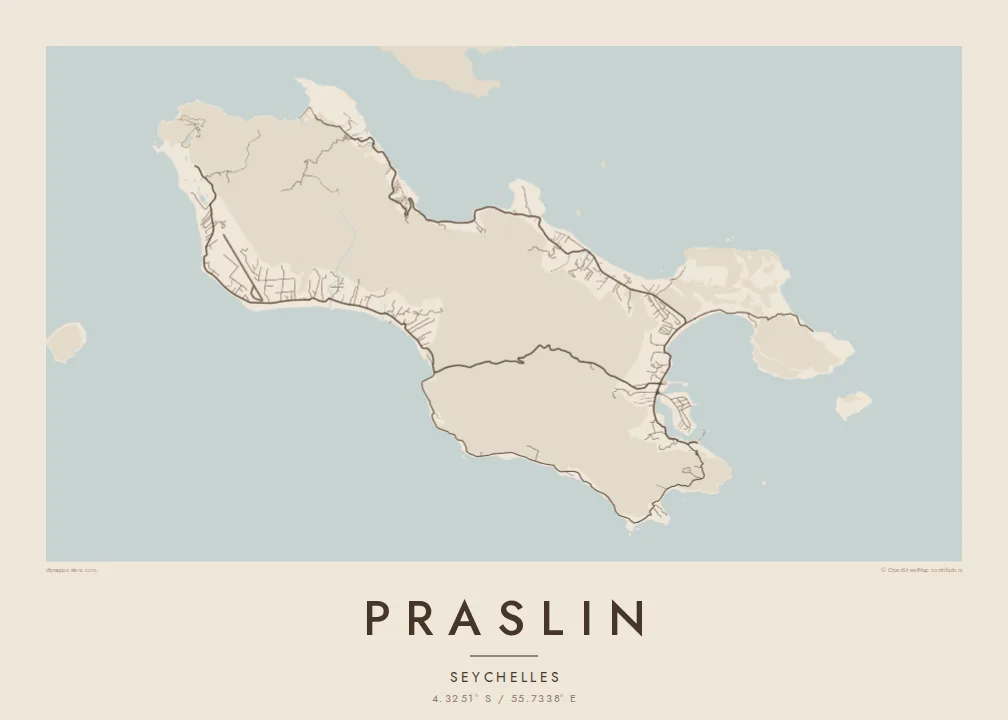
A long granite island running east to west, its coast scalloped into coves with a forested valley at its centre


עיר אחת, חמש אווירות
הקישו על סגנון כדי לראות אותו על הקיר. כל הסגנונות עולים אותו מחיר — מודפס, ממוסגר או כקבצי HD.
 פיקסלים אמיתיים · קובץ הדפסה 24 × 36″
חדות של הדפסה
זהו קטע בגודל 100% מקובץ ההדפסה האמיתי. כל פוסטר — מודפס, ממוסגר או מורד — מעובד בשרתים שלנו ברזולוציה של 300 DPI, עד 7,200 × 10,800 פיקסלים, כך שאפילו הרחובות הקטנים ביותר נשארים חדים בהדפסה בגודל 24 × 36″.
על הקיר


המפה
Praslin is the second-largest island of the Seychelles, a granite island rather than a coral atoll. From above it is long and fairly narrow, lying roughly east to west. Its shoreline is cut into a string of small bays, each marked by a thin line of coastal road and a pale strip of sand. The interior rises into wooded hills that the road network skirts rather than crosses.
The island is best known for the Vallée de Mai, a UNESCO World Heritage palm forest and one of the few places where the coco de mer grows wild. On a map it shows as an unbroken block in the middle of the island, crossed by a single road. Anse Lazio, on the northwest tip, is among the most photographed beaches in the Indian Ocean.
A Praslin map poster traces the loop of roads joining the coastal villages, the airstrip on the flat ground near the shore, and the jetty where boats leave for Mahé and La Digue. With so few streets, the drawing depends on coastline and contour: headlands, reefs and the curve of each anse come through in fine black line against open white water.
A protected palm forest in the island's interior, listed by UNESCO and home to the coco de mer. On the map it is a quiet, road-free area surrounded by the hills.
The shore breaks into one small bay after another, each named anse. Seen together they give the island an irregular, finely notched outline that works well in pure line.
At the northwest end of the island, this curved beach sits between two granite headlands. It is one of the Seychelles' best-known shorelines and marks the point where the road ends.
התאימו אישית
הוסיפו תאריך, שם או שורה משלכם, והחליפו סגנון, גודל או כיוון.
התצוגה המקדימה החינמית היא ברזולוציה נמוכה ועם סימן מים. ההדפסים וקבצי ה-HD מעובדים ברזולוציה של 300 DPI, עד 7,200 × 10,800 px, ללא סימן מים.
למה Praslin
People hang Praslin for a honeymoon, a dive trip or a stay on the islands, often as a quieter keepsake than a photograph. The coastline carries the memory, and the empty interior leaves room for the eye to rest.
Add the name of your bay or the dates of your trip to the title and subtitle, and set the coordinates line to where you stayed. Sand and Paper suit the granite and beaches, while Blueprint turns the reef line into something more technical.
הזמינו את פוסטר Praslin| גודל הדפסה | רזולוציה | קבצים |
|---|---|---|
| 30 × 40 cm (11.8 × 15.7″) | 3,543 × 4,724 px | PNG · PDF |
| 29.7 × 42 cm (A3, 11.7 × 16.5″) | 3,508 × 4,961 px | PNG · PDF |
| 42 × 59.4 cm (A2, 16.5 × 23.4″) | 4,961 × 7,016 px | PNG · PDF |
| 45.7 × 61 cm (18 × 24″) | 5,400 × 7,200 px | PNG · PDF |
| 50 × 70 cm (19.7 × 27.6″) | 5,906 × 8,268 px | PNG · PDF |
| 61 × 91.4 cm (24 × 36″) | 7,200 × 10,800 px | PNG · PDF |
לשם השוואה, התצוגה המקדימה החינמית ברוחב 900 פיקסלים, עם סימן מים ומיועדת למסכים. לקובצי ה־HD רזולוציה גבוהה עד פי 8 בכל כיוון, והם מודפסים בצורה נקייה בגודל פוסטר מלא.
בחרו סגנון בראש העמוד, ואז בחרו פוסטר מודפס — גודל, ואם תרצו, גם מסגרת — או קבצי HD דיגיטליים. התשלום מתבצע בשלב אחד, ועמוד ההזמנה שלכם מתעדכן ברגע שהתשלום מאושר.
הוא מודפס על נייר מאט פרימיום במשקל 200 גרם, באחד משישה גדלים, מ-30 × 40 ס״מ ועד 24 × 36″. פוסטרים מודפסים מתחילים ב-$39, כולל משלוח.
כן. בחרו מסגרת מעץ מלא בשחור, לבן, אלון טבעי או עץ כהה. המסגרת מגיעה עם זכוכית בטיחותית ומוכנה לתלייה. פוסטרים ממוסגרים מתחילים ב-$99, כולל משלוח.
המשלוח חינם בכל העולם. כל פוסטר מודפס אצל שותף ההדפסה הקרוב ביותר אליכם, מבין שותפינו ביותר מ-30 מדינות, ובדרך כלל מגיע תוך 3–7 ימי עסקים. את הסטטוס ומעקב המשלוח אפשר לראות ב"ההזמנות שלי". למדינות מסוימות המשלוח לוקח 2–5 שבועות, ובמדינות שאליהן אנחנו עוד לא שולחים, האתר יודיע לכם לפני התשלום.
שלחו לנו תמונה תוך 14 יום מקבלת המשלוח, ואנחנו נדפיס אותו מחדש בחינם או נחזיר לכם את הכסף.
כן. בעורך שבעמוד הזה אפשר לשנות את הכותרת, כותרת המשנה ושורת הקואורדינטות לכל מה שתרצו, ולבחור סגנון וגודל. הזמנות מודפסות, ממוסגרות ודיגיטליות משתמשות בדיוק בעיצוב שלכם.
תמורת $9 תקבלו קבצי PNG ו-PDF מוכנים להדפסה ברזולוציה של 300 DPI, בכל שישה הגדלים, ללא סימן מים, להדפסה בכל מקום. עוד לא בטוחים? הורידו קודם תצוגה מקדימה חינמית עם סימן מים.
