Irrigation grid
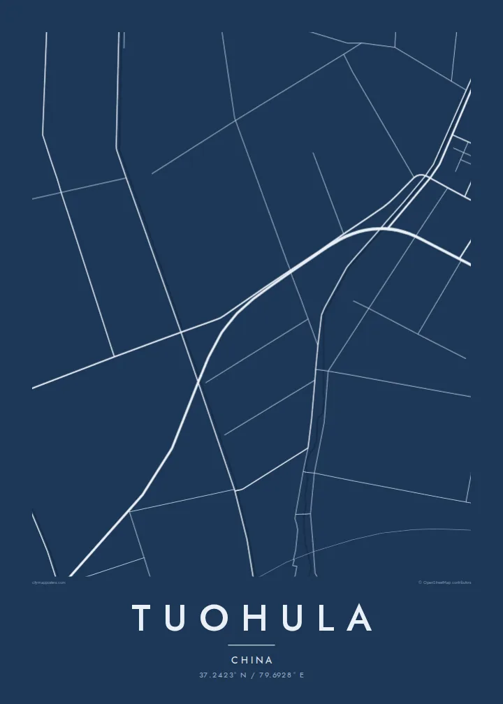
Canals and field roads divide the oasis into long, regular strips, a pattern shaped by water distribution that reads on the poster as a finely ruled geometric surface.
פוסטר מפה מינימליסטי · סין
37.2423° N / 79.6928° E
An oasis settlement on the southern rim of the Taklamakan, drawn in irrigation channels, tree-lined roads and long field strips.



עיר אחת, חמש אווירות
הקישו על סגנון כדי לראות אותו על הקיר. כל הסגנונות עולים אותו מחיר — מודפס, ממוסגר או כקבצי HD.
 פיקסלים אמיתיים · קובץ הדפסה 24 × 36″
חדות של הדפסה
זהו קטע בגודל 100% מקובץ ההדפסה האמיתי. כל פוסטר — מודפס, ממוסגר או מורד — מעובד בשרתים שלנו ברזולוציה של 300 DPI, עד 7,200 × 10,800 פיקסלים, כך שאפילו הרחובות הקטנים ביותר נשארים חדים בהדפסה בגודל 24 × 36″.
על הקיר


המפה
Tuohula lies in the Hotan area of southern Xinjiang, within the band of oases along the northern foot of the Kunlun Mountains, at the edge of the Taklamakan Desert. Life here depends on meltwater rivers coming down from the mountains, and that dependence is written clearly on any map of the place.
Within the oasis, roads, canals and field boundaries form a closely ruled pattern of long rectangles, typically lined with rows of trees that act as windbreaks. Houses string along the roads rather than gathering into one dense centre. Beyond the last irrigated plots the lines stop abruptly, and the map turns to open desert with almost no markings.
A Tuohula map poster is a study in contrast between cultivated order and empty ground. It suits anyone interested in the oases of the Tarim Basin, where settlements have long depended on careful water management. The result is an unusually graphic print in which the edge of the green zone becomes the main subject.
Canals and field roads divide the oasis into long, regular strips, a pattern shaped by water distribution that reads on the poster as a finely ruled geometric surface.
Homes line the roads in continuous ribbons instead of forming a compact town, so the built-up area shows as linear strokes running through the fields.
Where irrigation ends, the map falls almost silent. The sharp boundary between farmed land and the Taklamakan is the most striking line in the composition.
התאימו אישית
הוסיפו תאריך, שם או שורה משלכם, והחליפו סגנון, גודל או כיוון.
התצוגה המקדימה החינמית היא ברזולוציה נמוכה ועם סימן מים. ההדפסים וקבצי ה-HD מעובדים ברזולוציה של 300 DPI, עד 7,200 × 10,800 px, ללא סימן מים.
למה Tuohula
For people from the Hotan region, the pattern of fields and channels around their village is deeply familiar. For others, the map is a striking abstract image of a community holding its ground at the edge of one of the world's great deserts.
Personalise the title, subtitle and coordinates, and pick one of five styles. Sand and Paper suit the desert setting. Digital files cost $9 and cover six print sizes, and printed posters on matte paper ship from partners in more than 30 countries.
הזמינו את פוסטר Tuohula| גודל הדפסה | רזולוציה | קבצים |
|---|---|---|
| 30 × 40 cm (11.8 × 15.7″) | 3,543 × 4,724 px | PNG · PDF |
| 29.7 × 42 cm (A3, 11.7 × 16.5″) | 3,508 × 4,961 px | PNG · PDF |
| 42 × 59.4 cm (A2, 16.5 × 23.4″) | 4,961 × 7,016 px | PNG · PDF |
| 45.7 × 61 cm (18 × 24″) | 5,400 × 7,200 px | PNG · PDF |
| 50 × 70 cm (19.7 × 27.6″) | 5,906 × 8,268 px | PNG · PDF |
| 61 × 91.4 cm (24 × 36″) | 7,200 × 10,800 px | PNG · PDF |
לשם השוואה, התצוגה המקדימה החינמית ברוחב 900 פיקסלים, עם סימן מים ומיועדת למסכים. לקובצי ה־HD רזולוציה גבוהה עד פי 8 בכל כיוון, והם מודפסים בצורה נקייה בגודל פוסטר מלא.
בחרו סגנון בראש העמוד, ואז בחרו פוסטר מודפס — גודל, ואם תרצו, גם מסגרת — או קבצי HD דיגיטליים. התשלום מתבצע בשלב אחד, ועמוד ההזמנה שלכם מתעדכן ברגע שהתשלום מאושר.
הוא מודפס על נייר מאט פרימיום במשקל 200 גרם, באחד משישה גדלים, מ-30 × 40 ס״מ ועד 24 × 36″. פוסטרים מודפסים מתחילים ב-$39, כולל משלוח.
כן. בחרו מסגרת מעץ מלא בשחור, לבן, אלון טבעי או עץ כהה. המסגרת מגיעה עם זכוכית בטיחותית ומוכנה לתלייה. פוסטרים ממוסגרים מתחילים ב-$99, כולל משלוח.
המשלוח חינם בכל העולם. כל פוסטר מודפס אצל שותף ההדפסה הקרוב ביותר אליכם, מבין שותפינו ביותר מ-30 מדינות, ובדרך כלל מגיע תוך 3–7 ימי עסקים. את הסטטוס ומעקב המשלוח אפשר לראות ב"ההזמנות שלי". למדינות מסוימות המשלוח לוקח 2–5 שבועות, ובמדינות שאליהן אנחנו עוד לא שולחים, האתר יודיע לכם לפני התשלום.
שלחו לנו תמונה תוך 14 יום מקבלת המשלוח, ואנחנו נדפיס אותו מחדש בחינם או נחזיר לכם את הכסף.
כן. בעורך שבעמוד הזה אפשר לשנות את הכותרת, כותרת המשנה ושורת הקואורדינטות לכל מה שתרצו, ולבחור סגנון וגודל. הזמנות מודפסות, ממוסגרות ודיגיטליות משתמשות בדיוק בעיצוב שלכם.
תמורת $9 תקבלו קבצי PNG ו-PDF מוכנים להדפסה ברזולוציה של 300 DPI, בכל שישה הגדלים, ללא סימן מים, להדפסה בכל מקום. עוד לא בטוחים? הורידו קודם תצוגה מקדימה חינמית עם סימן מים.
