Curving suburbs
Residential areas are built around loops and crescents rather than a grid, each suburb forming its own distinct shape on the map.
Postè kat minimalis · South Africa
33.5667° S / 18.4834° E
A planned town on the sandy West Coast north of Cape Town, its looping streets set among dunes and fynbos.
Yon vil, senk atmosfè
Peze yon style pou wè li sou mi a. Chak style koute menm pri — enprime, ankadre oswa kòm fichye HD.
 Piksèl reyèl · fichye enpresyon 24 × 36″
Byen klè pou enprime
Sa a se yon zoom 100% sou vrè fichye enpresyon an. Chak afich — enprime, ankadre oswa telechaje — jenere sou sèvè nou yo nan 300 DPI, jiska 7,200 × 10,800 piksèl, konsa menm pi piti wout yo rete klè sou yon enpresyon 24 × 36″.
Sou mi a


Kat la
Atlantis lies about forty kilometres north of Cape Town, in the flat, sandy country of the Western Cape's West Coast. It was established in the 1970s as a planned town under apartheid-era policy, intended as a residential and industrial centre for people classified as coloured, and its layout reflects that origin.
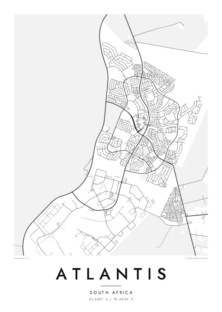
From above, Atlantis looks very different from older Cape towns. Residential areas are arranged in separate suburbs with curving streets and crescents, divided by open strips and main roads, while an industrial zone sits apart from the housing. Around the town, low vegetation and the white Atlantis dunes stretch toward the Atlantic coast.
An Atlantis map poster shows this planned structure plainly: the neighbourhood clusters, the roads tying them together, and the open land around the edges. The strong outlines and empty sandveld give the drawing a spare, graphic quality, and the history behind the town adds weight to what might look at first like a simple suburban plan.
Residential areas are built around loops and crescents rather than a grid, each suburb forming its own distinct shape on the map.
A large industrial area lies apart from the housing, a planned division that shows clearly as a zone of larger, more regular plots.
Open sandveld and white dunes surround the town toward the coast, leaving a wide empty margin that frames the built-up area.
Fè l pou ou
Ajoute yon dat, yon non oswa pwòp fraz pa w, chanje estil, gwosè oswa oryantasyon.
Apèsi gratis la se nan rezolisyon ba avèk yon watèrmak. Enpresyon ak fichye HD yo jenere nan 300 DPI, jiska 7,200 × 10,800 px, san watèrmak.
Poukisa Atlantis
For families who have lived in Atlantis for generations, the map records the streets and suburbs of home. It also speaks to anyone interested in how the history of the Western Cape is written into its town plans.
Personalise the title, subtitle and coordinates line with a suburb name, a family date or a short dedication. Choose Classic black & white, Noir, Paper, Blueprint or Sand, with Sand reflecting the dunes nearby.
Kòmande afich Atlantis a| Gwosè enpresyon | Rezolisyon | Fichye |
|---|---|---|
| 30 × 40 cm11.8 × 15.7″ | 3,543 × 4,724 px | PNG · PDF |
| 29.7 × 42 cm (A3)11.7 × 16.5″ | 3,508 × 4,961 px | PNG · PDF |
| 42 × 59.4 cm (A2)16.5 × 23.4″ | 4,961 × 7,016 px | PNG · PDF |
| 45.7 × 61 cm18 × 24″ | 5,400 × 7,200 px | PNG · PDF |
| 50 × 70 cm19.7 × 27.6″ | 5,906 × 8,268 px | PNG · PDF |
| 61 × 91.4 cm24 × 36″ | 7,200 × 10,800 px | PNG · PDF |
Pou konpare, apèsi gratis la gen 900 px lajè, li gen filigràn epi li fèt pou ekran. Fichye HD yo gen jiska 8 fwa plis rezolisyon nan chak direksyon epi yo enprime pwòp nan gwosè postè konplè.
Chwazi yon style anlè paj la, epi chwazi Afich Enprime — yon gwosè epi, si w vle, yon kad — oswa Fichye Dijital HD. Peman an fèt nan yon sèl etap, epi paj kòmand ou a mete ajou kou peman an konfime.
Li enprime sou papye mat premium 200 gsm nan youn nan sis gwosè, soti nan 30 × 40 cm rive nan 24 × 36″. Afich enprime yo kòmanse nan $39, livrezon enkli.
Wi. Chwazi yon kad an bwa solid nan koulè nwa, blan, chenn natirèl oswa bwa fonse. Li vin ak yon vit ki pa kase epi li pare pou pandye. Afich ankadre yo kòmanse nan $99, livrezon enkli.
Livrezon gratis nan plis pase 60 peyi. Chak afich enprime pa patnè enprimeri ki pi pre w la nan plis pase 30 peyi, e anjeneral li rive nan 3 a 7 jou ouvrab. Ou ka suiv estati a ak swivi kolis la nan Kòmand mwen yo. Kèk peyi pran 2 a 5 semèn, e kote nou poko livre, sit la di w sa anvan w peye.
Voye nou yon foto nan 14 jou apre livrezon an epi nou ap reenprime li gratis oswa remèt ou lajan w.
Wi. Nan editè a sou paj sa a, chanje tit la, soutit la ak liy kowòdone yo pou nenpòt sa w vle, epi chwazi yon style ak yon gwosè. Kòmand enprime, ankadre ak dijital yo tout itilize egzakteman desen w lan.
Pou $9 ou jwenn fichye PNG 300 DPI ak PDF pare-pou-enprime nan tout sis gwosè yo, san watèrmak, pou enprime kote w vle. Pa sèten toujou? Telechaje yon apèsi gratis ak watèrmak anvan.
