Dana Point Harbor
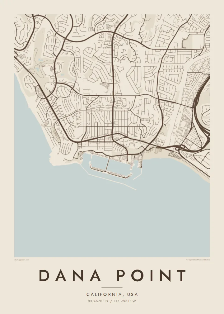
Long breakwaters enclose the harbour, creating a sheltered basin of marinas and boat slips that forms the most geometric shape on the coastline.
Postè kat minimalis · United States
33.4670° N / 117.6981° W
A coastal city of headlands, a sheltered harbour and canyon streets, stepping down to the Pacific in Orange County.


Yon vil, senk atmosfè
Peze yon style pou wè li sou mi a. Chak style koute menm pri — enprime, ankadre oswa kòm fichye HD.
 Piksèl reyèl · fichye enpresyon 24 × 36″
Byen klè pou enprime
Sa a se yon zoom 100% sou vrè fichye enpresyon an. Chak afich — enprime, ankadre oswa telechaje — jenere sou sèvè nou yo nan 300 DPI, jiska 7,200 × 10,800 piksèl, konsa menm pi piti wout yo rete klè sou yon enpresyon 24 × 36″.
Sou mi a


Kat la
Dana Point lies on the southern Orange County coast, between Laguna Beach and San Clemente. The map is shaped by the shoreline: rocky headlands, sandy coves and a large man-made harbour protected by long breakwaters. Streets follow the hills and canyons inland, curving around slopes and opening onto terraces that step down to the Pacific.
The city takes its name from Richard Henry Dana Jr., who described the headland in Two Years Before the Mast, his account of a voyage along the California coast in the 1830s. Today Dana Point Harbor is the centre of the city's waterfront, with marinas and boat slips laid out in neat geometric patterns inside the breakwater.
South of the harbour, San Juan Creek reaches the sea at Doheny State Beach, and the coast continues toward Capistrano Beach. Dana Point is also known for whale watching, with gray whales passing offshore during their migration. A Dana Point map poster shows this interplay of harbour, headland, beach and hillside neighbourhoods in clean detail.
Long breakwaters enclose the harbour, creating a sheltered basin of marinas and boat slips that forms the most geometric shape on the coastline.
Rocky promontories break up the shoreline, including the headland that gave the city its name, forming bold outlines against the sea.
Where San Juan Creek meets the ocean, the beach spreads in a broad sandy curve, adding a soft edge next to the harbour.
Fè l pou ou
Ajoute yon dat, yon non oswa pwòp fraz pa w, chanje estil, gwosè oswa oryantasyon.
Apèsi gratis la se nan rezolisyon ba avèk yon watèrmak. Enpresyon ak fichye HD yo jenere nan 300 DPI, jiska 7,200 × 10,800 px, san watèrmak.
Poukisa Dana Point
Dana Point's coastline makes a striking map, with harbour, headlands and beaches all in one frame. It suits a beach house, a sailing enthusiast or anyone who has watched whales off this stretch of coast.
Add a title, subtitle and coordinates, and choose Classic black & white, Noir, Paper, Blueprint or Sand. The digital files are $9 for six sizes, including 18×24″ and 24×36″, with printed posters available too.
Kòmande afich Dana Point a| Gwosè enpresyon | Rezolisyon | Fichye |
|---|---|---|
| 30 × 40 cm11.8 × 15.7″ | 3,543 × 4,724 px | PNG · PDF |
| 29.7 × 42 cm (A3)11.7 × 16.5″ | 3,508 × 4,961 px | PNG · PDF |
| 42 × 59.4 cm (A2)16.5 × 23.4″ | 4,961 × 7,016 px | PNG · PDF |
| 45.7 × 61 cm18 × 24″ | 5,400 × 7,200 px | PNG · PDF |
| 50 × 70 cm19.7 × 27.6″ | 5,906 × 8,268 px | PNG · PDF |
| 61 × 91.4 cm24 × 36″ | 7,200 × 10,800 px | PNG · PDF |
Pou konpare, apèsi gratis la gen 900 px lajè, li gen filigràn epi li fèt pou ekran. Fichye HD yo gen jiska 8 fwa plis rezolisyon nan chak direksyon epi yo enprime pwòp nan gwosè postè konplè.
Chwazi yon style anlè paj la, epi chwazi Afich Enprime — yon gwosè epi, si w vle, yon kad — oswa Fichye Dijital HD. Peman an fèt nan yon sèl etap, epi paj kòmand ou a mete ajou kou peman an konfime.
Li enprime sou papye mat premium 200 gsm nan youn nan sis gwosè, soti nan 30 × 40 cm rive nan 24 × 36″. Afich enprime yo kòmanse nan $39, livrezon enkli.
Wi. Chwazi yon kad an bwa solid nan koulè nwa, blan, chenn natirèl oswa bwa fonse. Li vin ak yon vit ki pa kase epi li pare pou pandye. Afich ankadre yo kòmanse nan $99, livrezon enkli.
Livrezon gratis nan plis pase 60 peyi. Chak afich enprime pa patnè enprimeri ki pi pre w la nan plis pase 30 peyi, e anjeneral li rive nan 3 a 7 jou ouvrab. Ou ka suiv estati a ak swivi kolis la nan Kòmand mwen yo. Kèk peyi pran 2 a 5 semèn, e kote nou poko livre, sit la di w sa anvan w peye.
Voye nou yon foto nan 14 jou apre livrezon an epi nou ap reenprime li gratis oswa remèt ou lajan w.
Wi. Nan editè a sou paj sa a, chanje tit la, soutit la ak liy kowòdone yo pou nenpòt sa w vle, epi chwazi yon style ak yon gwosè. Kòmand enprime, ankadre ak dijital yo tout itilize egzakteman desen w lan.
Pou $9 ou jwenn fichye PNG 300 DPI ak PDF pare-pou-enprime nan tout sis gwosè yo, san watèrmak, pou enprime kote w vle. Pa sèten toujou? Telechaje yon apèsi gratis ak watèrmak anvan.
