River embankments
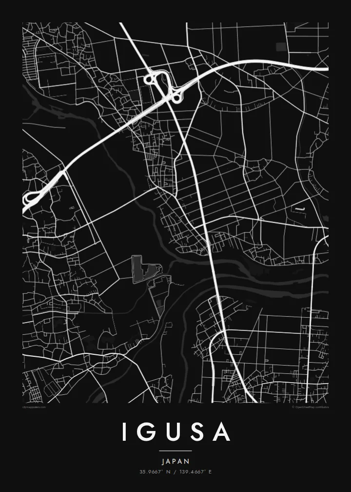
Raised levees follow the nearby rivers in long, steady lines. They are the most dominant structures in the landscape and frame the settlement.
Postè kat minimalis · Japan
35.9667° N / 139.4667° E
A low-lying Saitama settlement among rivers and rice fields, its lanes set on flat ground between embankments



Yon vil, senk atmosfè
Peze yon style pou wè li sou mi a. Chak style koute menm pri — enprime, ankadre oswa kòm fichye HD.
 Piksèl reyèl · fichye enpresyon 24 × 36″
Byen klè pou enprime
Sa a se yon zoom 100% sou vrè fichye enpresyon an. Chak afich — enprime, ankadre oswa telechaje — jenere sou sèvè nou yo nan 300 DPI, jiska 7,200 × 10,800 piksèl, konsa menm pi piti wout yo rete klè sou yon enpresyon 24 × 36″.
Sou mi a


Kat la
Igusa is a settlement in central Saitama Prefecture, on the flat lowland north of Tokyo that is crossed by several large rivers. The land is level and low, and the map reflects this. Rice paddies divide the countryside into regular rectangles, rivers run between high embankments, and houses cluster along lanes that follow the older field boundaries.
This part of Saitama has long been shaped by flood control. Levees and river channels appear on the map as long, strong lines, and some of the roads run on top of them. Between the rivers the land fills up with a mix of farmland, small residential blocks and newer suburban housing. It is a quiet landscape, but a very ordered one.
An Igusa map poster shows how rural and suburban Japan meet on the Kantō plain. The geometric paddies, the lines of embankments and the small grid of homes sit together in balanced proportion. For anyone with a family home or childhood memories here, the map captures the particular flatness and order of the place.
Raised levees follow the nearby rivers in long, steady lines. They are the most dominant structures in the landscape and frame the settlement.
Rice fields divide the flat land into neat rectangles, filling the map with a regular pattern that suits a monochrome style.
Houses gather along narrow lanes that follow old field edges, so the residential areas look irregular next to the paddies.
Fè l pou ou
Ajoute yon dat, yon non oswa pwòp fraz pa w, chanje estil, gwosè oswa oryantasyon.
Apèsi gratis la se nan rezolisyon ba avèk yon watèrmak. Enpresyon ak fichye HD yo jenere nan 300 DPI, jiska 7,200 × 10,800 px, san watèrmak.
Poukisa Igusa
A map of Igusa is a thoughtful gift for someone who grew up in this part of Saitama or who still returns to a family home there. The flat, ordered landscape looks calm and clean on the wall.
Personalise the title, subtitle and coordinates line, and choose from Classic black & white, Noir, Paper, Blueprint or Sand. Download HD files for $9 or order a matte print with an optional wooden frame.
Kòmande afich Igusa a| Gwosè enpresyon | Rezolisyon | Fichye |
|---|---|---|
| 30 × 40 cm (11.8 × 15.7″) | 3,543 × 4,724 px | PNG · PDF |
| 29.7 × 42 cm (A3, 11.7 × 16.5″) | 3,508 × 4,961 px | PNG · PDF |
| 42 × 59.4 cm (A2, 16.5 × 23.4″) | 4,961 × 7,016 px | PNG · PDF |
| 45.7 × 61 cm (18 × 24″) | 5,400 × 7,200 px | PNG · PDF |
| 50 × 70 cm (19.7 × 27.6″) | 5,906 × 8,268 px | PNG · PDF |
| 61 × 91.4 cm (24 × 36″) | 7,200 × 10,800 px | PNG · PDF |
Pou konpare, apèsi gratis la gen 900 px lajè, li gen filigràn epi li fèt pou ekran. Fichye HD yo gen jiska 8 fwa plis rezolisyon nan chak direksyon epi yo enprime pwòp nan gwosè postè konplè.
Chwazi yon style anlè paj la, epi chwazi Afich Enprime — yon gwosè epi, si w vle, yon kad — oswa Fichye Dijital HD. Peman an fèt nan yon sèl etap, epi paj kòmand ou a mete ajou kou peman an konfime.
Li enprime sou papye mat premium 200 gsm nan youn nan sis gwosè, soti nan 30 × 40 cm rive nan 24 × 36″. Afich enprime yo kòmanse nan $39, livrezon enkli.
Wi. Chwazi yon kad an bwa solid nan koulè nwa, blan, chenn natirèl oswa bwa fonse. Li vin ak yon vit ki pa kase epi li pare pou pandye. Afich ankadre yo kòmanse nan $99, livrezon enkli.
Livrezon an gratis nan tout mond lan. Se pi pwòch nan patnè enprimri nou yo nan plis pase 30 peyi ki enprime chak afich la, epi li anjeneral rive nan 3–7 jou ouvrab. Ou ka swiv estati ak swivi kolis la nan Kòmand mwen yo. Gen kèk peyi ki pran 2–5 semèn, e kote nou poko livre a, sit la di w anvan ou peye.
Voye nou yon foto nan 14 jou apre livrezon an epi nou ap reenprime li gratis oswa remèt ou lajan w.
Wi. Nan editè a sou paj sa a, chanje tit la, soutit la ak liy kowòdone yo pou nenpòt sa w vle, epi chwazi yon style ak yon gwosè. Kòmand enprime, ankadre ak dijital yo tout itilize egzakteman desen w lan.
Pou $9 ou jwenn fichye PNG 300 DPI ak PDF pare-pou-enprime nan tout sis gwosè yo, san watèrmak, pou enprime kote w vle. Pa sèten toujou? Telechaje yon apèsi gratis ak watèrmak anvan.
