Heian-era grid
The regular grid of streets in central Kyoto dates back to the city's founding. It is laid out along a north–south axis and reads with rare clarity from above.
Postè kat minimalis · Japan
35.0211° N / 135.7538° E
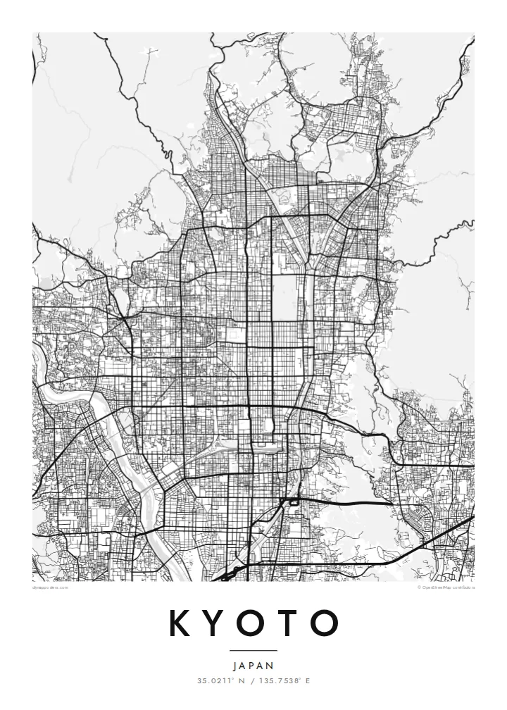
An ancient grid laid across a valley floor, bounded by wooded mountains and traced by the Kamo River


Yon vil, senk atmosfè
Peze yon style pou wè li sou mi a. Chak style koute menm pri — enprime, ankadre oswa kòm fichye HD.
 Piksèl reyèl · fichye enpresyon 24 × 36″
Byen klè pou enprime
Sa a se yon zoom 100% sou vrè fichye enpresyon an. Chak afich — enprime, ankadre oswa telechaje — jenere sou sèvè nou yo nan 300 DPI, jiska 7,200 × 10,800 piksèl, konsa menm pi piti wout yo rete klè sou yon enpresyon 24 × 36″.
Sou mi a


Kat la
Kyoto was founded in 794 as Heian-kyō and served as the imperial capital for more than a thousand years. Its plan was modelled on the Chinese capital Chang'an. That grid survives in the numbered east–west streets and long north–south avenues of the centre. Mountains close in on the north, east and west, and the city opens to the plain in the south.
The Kamo River runs down the eastern side of the centre, lined with walking paths. To the west the Katsura River flows past Arashiyama. The mountain edges are thick with temples and shrines. Higashiyama rises in the east, Fushimi Inari stands to the southeast, and the Kyoto Imperial Palace grounds form a large green rectangle within the grid.
A Kyoto map poster shows how strongly the city was planned and how the landscape holds it in place. The straight streets end where the mountains begin, and the rivers draw long lines down the valley. The balance between order and nature is visible in black and white. It makes one of the most elegant city maps in Asia.
The regular grid of streets in central Kyoto dates back to the city's founding. It is laid out along a north–south axis and reads with rare clarity from above.
The river runs straight south along the east side of downtown and is crossed by a series of bridges. Its long line is the spine of the eastern city.
The palace park forms a large open rectangle in the grid north of downtown. It is a quiet space that anchors the centre of the composition.
Fè l pou ou
Ajoute yon dat, yon non oswa pwòp fraz pa w, chanje estil, gwosè oswa oryantasyon.
Apèsi gratis la se nan rezolisyon ba avèk yon watèrmak. Enpresyon ak fichye HD yo jenere nan 300 DPI, jiska 7,200 × 10,800 px, san watèrmak.
Poukisa Kyoto
Kyoto is a city people remember in detail: a temple visit, a season, a stretch of the river path. Its map works as a keepsake of a journey and as a refined design object in its own right.
The poster can carry your own title, a subtitle with a date or phrase, and a coordinates line. Choose from Classic black & white, Noir, Paper, Blueprint or Sand to suit the room.
Kòmande afich Kyoto a| Gwosè enpresyon | Rezolisyon | Fichye |
|---|---|---|
| 30 × 40 cm (11.8 × 15.7″) | 3,543 × 4,724 px | PNG · PDF |
| 29.7 × 42 cm (A3, 11.7 × 16.5″) | 3,508 × 4,961 px | PNG · PDF |
| 42 × 59.4 cm (A2, 16.5 × 23.4″) | 4,961 × 7,016 px | PNG · PDF |
| 45.7 × 61 cm (18 × 24″) | 5,400 × 7,200 px | PNG · PDF |
| 50 × 70 cm (19.7 × 27.6″) | 5,906 × 8,268 px | PNG · PDF |
| 61 × 91.4 cm (24 × 36″) | 7,200 × 10,800 px | PNG · PDF |
Pou konpare, apèsi gratis la gen 900 px lajè, li gen filigràn epi li fèt pou ekran. Fichye HD yo gen jiska 8 fwa plis rezolisyon nan chak direksyon epi yo enprime pwòp nan gwosè postè konplè.
Chwazi yon style anlè paj la, epi chwazi Afich Enprime — yon gwosè epi, si w vle, yon kad — oswa Fichye Dijital HD. Peman an fèt nan yon sèl etap, epi paj kòmand ou a mete ajou kou peman an konfime.
Li enprime sou papye mat premium 200 gsm nan youn nan sis gwosè, soti nan 30 × 40 cm rive nan 24 × 36″. Afich enprime yo kòmanse nan $39, livrezon enkli.
Wi. Chwazi yon kad an bwa solid nan koulè nwa, blan, chenn natirèl oswa bwa fonse. Li vin ak yon vit ki pa kase epi li pare pou pandye. Afich ankadre yo kòmanse nan $99, livrezon enkli.
Livrezon an gratis nan tout mond lan. Se pi pwòch nan patnè enprimri nou yo nan plis pase 30 peyi ki enprime chak afich la, epi li anjeneral rive nan 3–7 jou ouvrab. Ou ka swiv estati ak swivi kolis la nan Kòmand mwen yo. Gen kèk peyi ki pran 2–5 semèn, e kote nou poko livre a, sit la di w anvan ou peye.
Voye nou yon foto nan 14 jou apre livrezon an epi nou ap reenprime li gratis oswa remèt ou lajan w.
Wi. Nan editè a sou paj sa a, chanje tit la, soutit la ak liy kowòdone yo pou nenpòt sa w vle, epi chwazi yon style ak yon gwosè. Kòmand enprime, ankadre ak dijital yo tout itilize egzakteman desen w lan.
Pou $9 ou jwenn fichye PNG 300 DPI ak PDF pare-pou-enprime nan tout sis gwosè yo, san watèrmak, pou enprime kote w vle. Pa sèten toujou? Telechaje yon apèsi gratis ak watèrmak anvan.
