Chain of lakes
Alta, Nita, Alpha and Green Lakes lie along the valley floor, giving the map a string of calm shapes between the highway, the railway and the residential streets.
Postè kat minimalis · Canada
50.1172° N / 122.9543° W
A valley strung with small lakes and the Sea-to-Sky Highway, two great mountains meeting at a compact pedestrian village.


Yon vil, senk atmosfè
Peze yon style pou wè li sou mi a. Chak style koute menm pri — enprime, ankadre oswa kòm fichye HD.
 Piksèl reyèl · fichye enpresyon 24 × 36″
Byen klè pou enprime
Sa a se yon zoom 100% sou vrè fichye enpresyon an. Chak afich — enprime, ankadre oswa telechaje — jenere sou sèvè nou yo nan 300 DPI, jiska 7,200 × 10,800 piksèl, konsa menm pi piti wout yo rete klè sou yon enpresyon 24 × 36″.
Sou mi a


Kat la
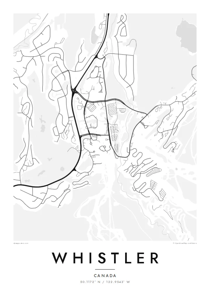
Whistler sits in a narrow valley of the Coast Mountains, and on the map its structure is easy to follow. Highway 99 runs north to south through the middle, a chain of lakes lies along the valley floor, and neighbourhoods branch off in short cul-de-sacs toward the slopes. Whistler Village gathers at the foot of both mountains, where Fitzsimmons Creek comes down between them.
Whistler and Blackcomb operated as rival ski areas until they came under one owner in the late 1990s, and since 2008 the Peak 2 Peak Gondola has linked their upper slopes across the Fitzsimmons valley. In 2010 the resort hosted the alpine skiing events of the Vancouver Winter Olympics, with the races run on Whistler Mountain above Creekside.
A Whistler map poster shows the resort the way it is actually organised: lakes, a highway, two peaks and a village pinned between them. The Valley Trail threads through it all, linking the lakes and neighbourhoods on a paved path that turns up clearly as a thin winding line alongside the main road and the railway.
Alta, Nita, Alpha and Green Lakes lie along the valley floor, giving the map a string of calm shapes between the highway, the railway and the residential streets.
Whistler Village is laid out as a car-free stroll of squares and walkways, a compact cluster that stands out against the looser suburban loops to the north and south.
The creek runs down between Whistler and Blackcomb mountains and through the village, marking the split between the two ski areas that the gondola now spans high above.
Fè l pou ou
Ajoute yon dat, yon non oswa pwòp fraz pa w, chanje estil, gwosè oswa oryantasyon.
Apèsi gratis la se nan rezolisyon ba avèk yon watèrmak. Enpresyon ak fichye HD yo jenere nan 300 DPI, jiska 7,200 × 10,800 px, san watèrmak.
Poukisa Whistler
Whistler draws visitors from all over the world, along with plenty of people who came for a season and stayed. A map of the valley is a way to keep a sense of the place: the lakes you skated or swam in, the road to Vancouver, the village you walked through at the end of the day.
Personalise the poster with a title, a subtitle such as a season or a year, and a coordinates line, then choose Classic black & white, Noir, Paper, Blueprint or Sand. Printed posters come on matte paper, with an optional wooden frame, from print partners in more than 30 countries.
Kòmande afich Whistler a| Gwosè enpresyon | Rezolisyon | Fichye |
|---|---|---|
| 30 × 40 cm11.8 × 15.7″ | 3,543 × 4,724 px | PNG · PDF |
| 29.7 × 42 cm (A3)11.7 × 16.5″ | 3,508 × 4,961 px | PNG · PDF |
| 42 × 59.4 cm (A2)16.5 × 23.4″ | 4,961 × 7,016 px | PNG · PDF |
| 45.7 × 61 cm18 × 24″ | 5,400 × 7,200 px | PNG · PDF |
| 50 × 70 cm19.7 × 27.6″ | 5,906 × 8,268 px | PNG · PDF |
| 61 × 91.4 cm24 × 36″ | 7,200 × 10,800 px | PNG · PDF |
Pou konpare, apèsi gratis la gen 900 px lajè, li gen filigràn epi li fèt pou ekran. Fichye HD yo gen jiska 8 fwa plis rezolisyon nan chak direksyon epi yo enprime pwòp nan gwosè postè konplè.
Chwazi yon style anlè paj la, epi chwazi Afich Enprime — yon gwosè epi, si w vle, yon kad — oswa Fichye Dijital HD. Peman an fèt nan yon sèl etap, epi paj kòmand ou a mete ajou kou peman an konfime.
Li enprime sou papye mat premium 200 gsm nan youn nan sis gwosè, soti nan 30 × 40 cm rive nan 24 × 36″. Afich enprime yo kòmanse nan $39, livrezon enkli.
Wi. Chwazi yon kad an bwa solid nan koulè nwa, blan, chenn natirèl oswa bwa fonse. Li vin ak yon vit ki pa kase epi li pare pou pandye. Afich ankadre yo kòmanse nan $99, livrezon enkli.
Livrezon gratis nan plis pase 60 peyi. Chak afich enprime pa patnè enprimeri ki pi pre w la nan plis pase 30 peyi, e anjeneral li rive nan 3 a 7 jou ouvrab. Ou ka suiv estati a ak swivi kolis la nan Kòmand mwen yo. Kèk peyi pran 2 a 5 semèn, e kote nou poko livre, sit la di w sa anvan w peye.
Voye nou yon foto nan 14 jou apre livrezon an epi nou ap reenprime li gratis oswa remèt ou lajan w.
Wi. Nan editè a sou paj sa a, chanje tit la, soutit la ak liy kowòdone yo pou nenpòt sa w vle, epi chwazi yon style ak yon gwosè. Kòmand enprime, ankadre ak dijital yo tout itilize egzakteman desen w lan.
Pou $9 ou jwenn fichye PNG 300 DPI ak PDF pare-pou-enprime nan tout sis gwosè yo, san watèrmak, pou enprime kote w vle. Pa sèten toujou? Telechaje yon apèsi gratis ak watèrmak anvan.
