Airfield runway
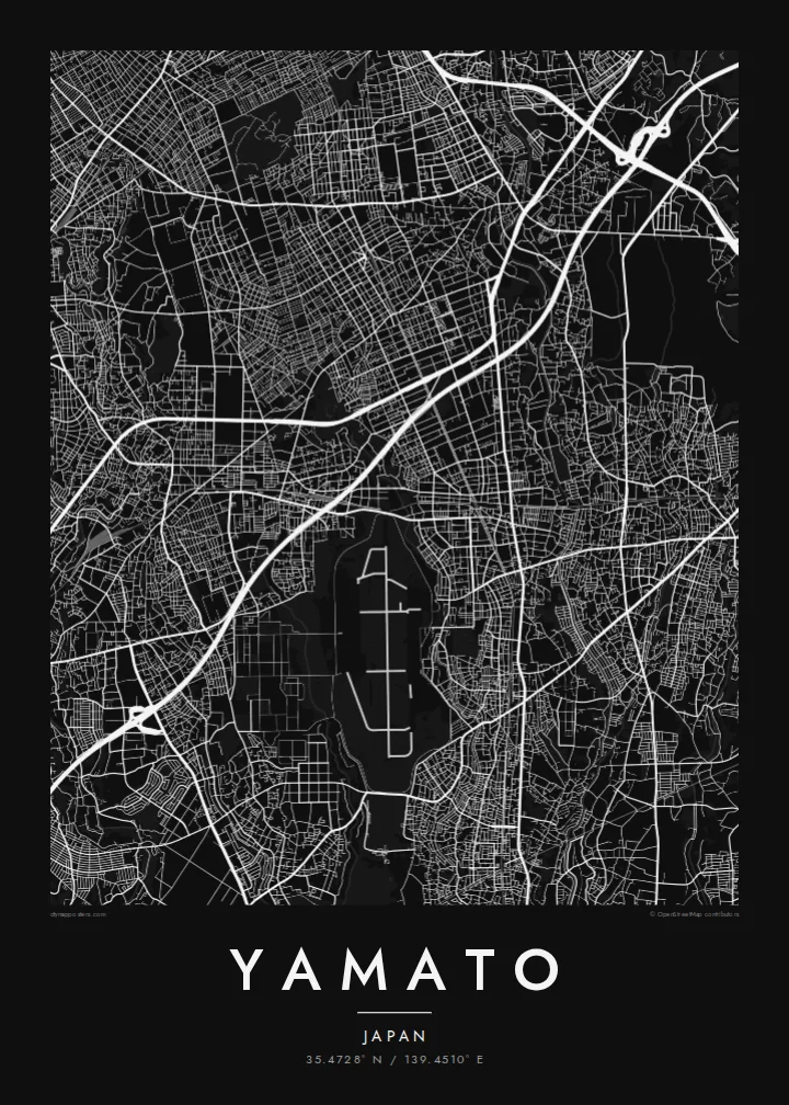
The long runway on the southern edge of the city forms a stark straight line and a large open space, one of the most recognisable shapes on any map of Yamato.
Postè kat minimalis · Japan
35.4728° N / 139.4510° E
A dense residential city on the Sagami Plateau, cut by rail lines and edged by a long runway to the south



Yon vil, senk atmosfè
Peze yon style pou wè li sou mi a. Chak style koute menm pri — enprime, ankadre oswa kòm fichye HD.
 Piksèl reyèl · fichye enpresyon 24 × 36″
Byen klè pou enprime
Sa a se yon zoom 100% sou vrè fichye enpresyon an. Chak afich — enprime, ankadre oswa telechaje — jenere sou sèvè nou yo nan 300 DPI, jiska 7,200 × 10,800 piksèl, konsa menm pi piti wout yo rete klè sou yon enpresyon 24 × 36″.
Sou mi a


Kat la
Yamato occupies a narrow strip of the Sagami Plateau in central Kanagawa, and from above it looks like a finely packed mosaic of small lots and winding residential lanes. Several suburban rail lines cross it, each marked by a string of stations around which the streets tighten. There is no single old centre here; instead the city reads as a series of station neighbourhoods joined into one continuous fabric.
The most striking shape on the map is the long straight runway of the Atsugi air facility, which lies across the city's southern boundary and interrupts the dense streets with a clean geometric void. Small rivers run north to south along the plateau, including one that traces the eastern boundary, adding soft curving lines to an otherwise tight grid.
A Yamato map poster captures the texture of commuter-belt Japan at its most characteristic: thousands of short streets, careful green pockets of woodland park and shrine grounds, and railways drawn as firm diagonal strokes. It is a pattern that rewards close looking, because the detail is in the small scale rather than in any one landmark.
The long runway on the southern edge of the city forms a stark straight line and a large open space, one of the most recognisable shapes on any map of Yamato.
Where the rail lines meet their stations, the street grid compresses into small commercial centres, giving the map several focal points instead of a single downtown.
Narrow rivers and their green margins run lengthwise through the city, drawing gentle curves through the otherwise dense and irregular residential street pattern.
Fè l pou ou
Ajoute yon dat, yon non oswa pwòp fraz pa w, chanje estil, gwosè oswa oryantasyon.
Apèsi gratis la se nan rezolisyon ba avèk yon watèrmak. Enpresyon ak fichye HD yo jenere nan 300 DPI, jiska 7,200 × 10,800 px, san watèrmak.
Poukisa Yamato
For people who live in or commute through Yamato, the map shows home as it actually is: the lanes walked to the station, the park at the end of the road, the line home from Yokohama or Tokyo. It is a quiet, detailed image that suits a hallway or a study.
The title, subtitle and coordinates can all be changed, so it can mark a first apartment or a family address with a date. Pick one of five styles, from Classic black and white and Noir to Paper, Blueprint and Sand, as a digital download or a framed print.
Kòmande afich Yamato a| Gwosè enpresyon | Rezolisyon | Fichye |
|---|---|---|
| 30 × 40 cm11.8 × 15.7″ | 3,543 × 4,724 px | PNG · PDF |
| 29.7 × 42 cm (A3)11.7 × 16.5″ | 3,508 × 4,961 px | PNG · PDF |
| 42 × 59.4 cm (A2)16.5 × 23.4″ | 4,961 × 7,016 px | PNG · PDF |
| 45.7 × 61 cm18 × 24″ | 5,400 × 7,200 px | PNG · PDF |
| 50 × 70 cm19.7 × 27.6″ | 5,906 × 8,268 px | PNG · PDF |
| 61 × 91.4 cm24 × 36″ | 7,200 × 10,800 px | PNG · PDF |
Pou konpare, apèsi gratis la gen 900 px lajè, li gen filigràn epi li fèt pou ekran. Fichye HD yo gen jiska 8 fwa plis rezolisyon nan chak direksyon epi yo enprime pwòp nan gwosè postè konplè.
Chwazi yon style anlè paj la, epi chwazi Afich Enprime — yon gwosè epi, si w vle, yon kad — oswa Fichye Dijital HD. Peman an fèt nan yon sèl etap, epi paj kòmand ou a mete ajou kou peman an konfime.
Li enprime sou papye mat premium 200 gsm nan youn nan sis gwosè, soti nan 30 × 40 cm rive nan 24 × 36″. Afich enprime yo kòmanse nan $39, livrezon enkli.
Wi. Chwazi yon kad an bwa solid nan koulè nwa, blan, chenn natirèl oswa bwa fonse. Li vin ak yon vit ki pa kase epi li pare pou pandye. Afich ankadre yo kòmanse nan $99, livrezon enkli.
Livrezon gratis nan plis pase 60 peyi. Chak afich enprime pa patnè enprimeri ki pi pre w la nan plis pase 30 peyi, e anjeneral li rive nan 3 a 7 jou ouvrab. Ou ka suiv estati a ak swivi kolis la nan Kòmand mwen yo. Kèk peyi pran 2 a 5 semèn, e kote nou poko livre, sit la di w sa anvan w peye.
Voye nou yon foto nan 14 jou apre livrezon an epi nou ap reenprime li gratis oswa remèt ou lajan w.
Wi. Nan editè a sou paj sa a, chanje tit la, soutit la ak liy kowòdone yo pou nenpòt sa w vle, epi chwazi yon style ak yon gwosè. Kòmand enprime, ankadre ak dijital yo tout itilize egzakteman desen w lan.
Pou $9 ou jwenn fichye PNG 300 DPI ak PDF pare-pou-enprime nan tout sis gwosè yo, san watèrmak, pou enprime kote w vle. Pa sèten toujou? Telechaje yon apèsi gratis ak watèrmak anvan.
