Minato Mirai 21
A modern waterfront district built on reclaimed land, with tall towers, open plazas and a large Ferris wheel forming a clean, planned edge along the bay.
Postè kat minimalis · Japan
35.4333° N / 139.6500° E
A port city on Tokyo Bay, with a waterfront of piers and reclaimed land and hills rising just behind the harbour.


Yon vil, senk atmosfè
Peze yon style pou wè li sou mi a. Chak style koute menm pri — enprime, ankadre oswa kòm fichye HD.
 Piksèl reyèl · fichye enpresyon 24 × 36″
Byen klè pou enprime
Sa a se yon zoom 100% sou vrè fichye enpresyon an. Chak afich — enprime, ankadre oswa telechaje — jenere sou sèvè nou yo nan 300 DPI, jiska 7,200 × 10,800 piksèl, konsa menm pi piti wout yo rete klè sou yon enpresyon 24 × 36″.
Sou mi a


Kat la
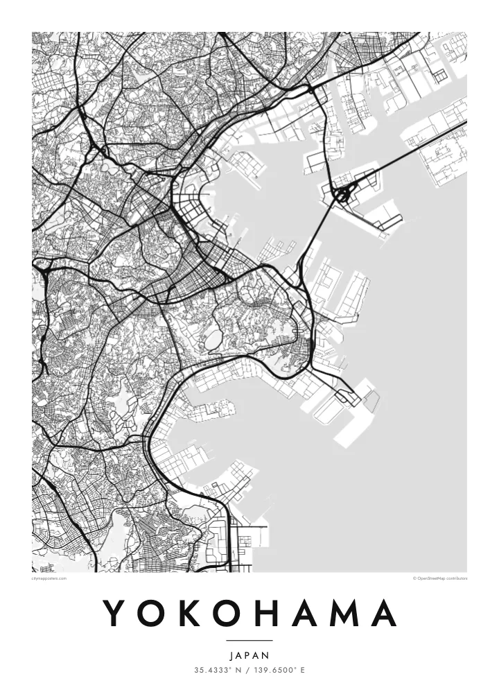
Yokohama faces Tokyo Bay, and from above its waterfront is a line of piers, reclaimed land and container terminals. The older city centre sits close to the harbour, with Yamashita Park running along the shore, while behind it the land climbs quickly into wooded hills. Further inland, residential districts spread across a rolling landscape of valleys and ridges.
The port opened to foreign trade in 1859, and the city grew from a small fishing village into one of the largest cities in Japan. The hill known as the Bluff, or Yamate, became home to foreign residents, and below it Chinatown, the largest in Japan, still fills a tight grid of streets with gates marking its edges.
Minato Mirai 21 added a new waterfront district of towers, museums and a large Ferris wheel on reclaimed land. A Yokohama map poster shows how the harbour, old town, Chinatown and new waterfront sit together, while the Bay Bridge crosses the entrance to the inner port as one of the most graphic lines on the map.
A modern waterfront district built on reclaimed land, with tall towers, open plazas and a large Ferris wheel forming a clean, planned edge along the bay.
The largest Chinatown in Japan fills a compact grid of streets near the harbour, framed by decorative gates that mark its entrances.
A long cable-stayed bridge crosses the harbour entrance, visible on the map as a thin straight line joining piers and industrial land across the water.
Fè l pou ou
Ajoute yon dat, yon non oswa pwòp fraz pa w, chanje estil, gwosè oswa oryantasyon.
Apèsi gratis la se nan rezolisyon ba avèk yon watèrmak. Enpresyon ak fichye HD yo jenere nan 300 DPI, jiska 7,200 × 10,800 px, san watèrmak.
Poukisa Yokohama
Yokohama is a city many people know from years of work or study near Tokyo, or from weekends on the harbour. A map poster keeps its waterfront and hills in view long after leaving, and it sits well beside a Tokyo print.
Write your own title and subtitle, add coordinates or a date, and pick a style: Classic black & white, Noir, Paper, Blueprint or Sand. The $9 HD files cover six sizes, including A3 and A2, each without a watermark.
Kòmande afich Yokohama a| Gwosè enpresyon | Rezolisyon | Fichye |
|---|---|---|
| 30 × 40 cm11.8 × 15.7″ | 3,543 × 4,724 px | PNG · PDF |
| 29.7 × 42 cm (A3)11.7 × 16.5″ | 3,508 × 4,961 px | PNG · PDF |
| 42 × 59.4 cm (A2)16.5 × 23.4″ | 4,961 × 7,016 px | PNG · PDF |
| 45.7 × 61 cm18 × 24″ | 5,400 × 7,200 px | PNG · PDF |
| 50 × 70 cm19.7 × 27.6″ | 5,906 × 8,268 px | PNG · PDF |
| 61 × 91.4 cm24 × 36″ | 7,200 × 10,800 px | PNG · PDF |
Pou konpare, apèsi gratis la gen 900 px lajè, li gen filigràn epi li fèt pou ekran. Fichye HD yo gen jiska 8 fwa plis rezolisyon nan chak direksyon epi yo enprime pwòp nan gwosè postè konplè.
Chwazi yon style anlè paj la, epi chwazi Afich Enprime — yon gwosè epi, si w vle, yon kad — oswa Fichye Dijital HD. Peman an fèt nan yon sèl etap, epi paj kòmand ou a mete ajou kou peman an konfime.
Li enprime sou papye mat premium 200 gsm nan youn nan sis gwosè, soti nan 30 × 40 cm rive nan 24 × 36″. Afich enprime yo kòmanse nan $39, livrezon enkli.
Wi. Chwazi yon kad an bwa solid nan koulè nwa, blan, chenn natirèl oswa bwa fonse. Li vin ak yon vit ki pa kase epi li pare pou pandye. Afich ankadre yo kòmanse nan $99, livrezon enkli.
Livrezon gratis nan plis pase 60 peyi. Chak afich enprime pa patnè enprimeri ki pi pre w la nan plis pase 30 peyi, e anjeneral li rive nan 3 a 7 jou ouvrab. Ou ka suiv estati a ak swivi kolis la nan Kòmand mwen yo. Kèk peyi pran 2 a 5 semèn, e kote nou poko livre, sit la di w sa anvan w peye.
Voye nou yon foto nan 14 jou apre livrezon an epi nou ap reenprime li gratis oswa remèt ou lajan w.
Wi. Nan editè a sou paj sa a, chanje tit la, soutit la ak liy kowòdone yo pou nenpòt sa w vle, epi chwazi yon style ak yon gwosè. Kòmand enprime, ankadre ak dijital yo tout itilize egzakteman desen w lan.
Pou $9 ou jwenn fichye PNG 300 DPI ak PDF pare-pou-enprime nan tout sis gwosè yo, san watèrmak, pou enprime kote w vle. Pa sèten toujou? Telechaje yon apèsi gratis ak watèrmak anvan.
