BR-116 and Trensurb
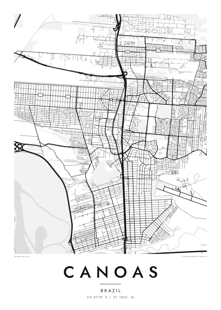
Highway and commuter rail run side by side through the city, a single strong vertical that divides Canoas into eastern and western halves.
Poster peta minimalis · Brasil
29.9178° S / 51.1836° W
A flat river-plain city north of Porto Alegre, split by a highway and hemmed in by two rivers.


Satu kota, lima nuansa
Ketuk salah satu gaya untuk melihatnya di dinding. Semua gaya harganya sama — baik cetak, berbingkai, maupun file HD.
 Piksel asli · file cetak 24 × 36″
Tajam saat dicetak
Ini adalah crop 100% dari file cetak asli. Setiap poster — dicetak, berbingkai, atau diunduh — dirender di server kami dengan 300 DPI, hingga 7,200 × 10,800 piksel, sehingga jalan sekecil apa pun tetap tajam pada cetakan 24 × 36″.
Di dinding

Peta
Canoas sits directly north of Porto Alegre in Rio Grande do Sul, and on a map the two cities almost merge. The key organising line is the BR-116 highway, which runs north to south through the middle of town with the Trensurb commuter rail beside it. Streets branch off this double spine into neighbourhoods of fairly regular blocks on either side.
The terrain is low and level. The Gravataí River bends along the southern edge and the Rio dos Sinos passes to the north, with the broad Guaíba waters not far to the west. Much of the western side lies close to river level, which is why the city was so badly affected in the 2024 Rio Grande do Sul floods, especially in the Mathias Velho district.
A Canoas map poster makes that geography easy to read: the straight transport corridor, the pale wetlands and levee lines, and the large open rectangle of the air force base that interrupts the street grid. It is a map of a working city shaped by roads, rail and water rather than by hills or an old centre.
Highway and commuter rail run side by side through the city, a single strong vertical that divides Canoas into eastern and western halves.
The Canoas air force base occupies a large open block in the urban fabric, a blank space with a runway that stands out clearly in monochrome.
The Gravataí and Sinos rivers and their floodplains surround the city, drawing soft, winding edges around the otherwise orderly street pattern.
Jadikan milik Anda
Tambahkan tanggal, nama, atau kalimat Anda sendiri, lalu ganti gaya, ukuran, atau orientasi.
Pratinjau gratis beresolusi rendah dan berwatermark. Cetakan dan file HD dirender dengan 300 DPI, hingga 7,200 × 10,800 px, tanpa watermark.
Mengapa Canoas
For many families in Canoas, the map carries weight after the floods: a record of the streets and neighbourhoods as they are. Others simply want the place where they grew up, studied or started work, drawn cleanly and without clutter.
Add a personal title, subtitle and coordinates line, then choose from Classic black & white, Noir, Paper, Blueprint or Sand. The $9 digital files cover six print sizes, and printed posters ship from partners in more than 30 countries.
Pesan poster Canoas| Ukuran cetak | Resolusi | File |
|---|---|---|
| 30 × 40 cm (11.8 × 15.7″) | 3,543 × 4,724 px | PNG · PDF |
| 29.7 × 42 cm (A3, 11.7 × 16.5″) | 3,508 × 4,961 px | PNG · PDF |
| 42 × 59.4 cm (A2, 16.5 × 23.4″) | 4,961 × 7,016 px | PNG · PDF |
| 45.7 × 61 cm (18 × 24″) | 5,400 × 7,200 px | PNG · PDF |
| 50 × 70 cm (19.7 × 27.6″) | 5,906 × 8,268 px | PNG · PDF |
| 61 × 91.4 cm (24 × 36″) | 7,200 × 10,800 px | PNG · PDF |
Sebagai perbandingan, pratinjau gratis lebarnya 900 px, bertanda watermark, dan ditujukan untuk layar. File HD memiliki resolusi hingga 8× lebih besar di setiap sisi dan tercetak jernih dalam ukuran poster penuh.
Pilih gaya di bagian atas halaman, lalu pilih Poster Cetak — beserta ukuran dan, jika suka, bingkai — atau File Digital HD. Checkout hanya satu langkah, dan halaman pesanan Anda langsung diperbarui begitu pembayaran berhasil.
Dicetak di atas kertas doff premium 200 gsm dalam salah satu dari enam ukuran, mulai dari 30 × 40 cm hingga 24 × 36″. Poster cetak mulai dari {printFrom}, sudah termasuk ongkos kirim.
Tentu. Pilih bingkai kayu solid berwarna hitam, putih, oak natural, atau kayu gelap. Dilengkapi kaca anti pecah dan siap digantung. Poster berbingkai mulai dari {framedFrom}, sudah termasuk ongkos kirim.
Pengiriman gratis ke seluruh dunia. Setiap poster dicetak oleh mitra cetak kami terdekat di lebih dari 30 negara dan biasanya tiba dalam 3–7 hari kerja. Anda bisa memantau status dan nomor lacaknya di Pesanan Saya.
Kirimkan foto kepada kami dalam 14 hari sejak pengiriman diterima, dan kami akan mencetak ulang secara gratis atau mengembalikan uang Anda.
Tentu. Di editor pada halaman ini, ubah judul, subjudul, dan baris koordinat sesuai keinginan Anda, lalu pilih gaya dan ukuran. Pesanan cetak, berbingkai, maupun digital semuanya menggunakan desain Anda persis.
Dengan $9 Anda mendapatkan file PNG 300 DPI dan PDF siap cetak dalam keenam ukuran, tanpa watermark, untuk dicetak di mana saja. Belum yakin? Unduh dulu pratinjau gratis berwatermark.
