Wizard Island
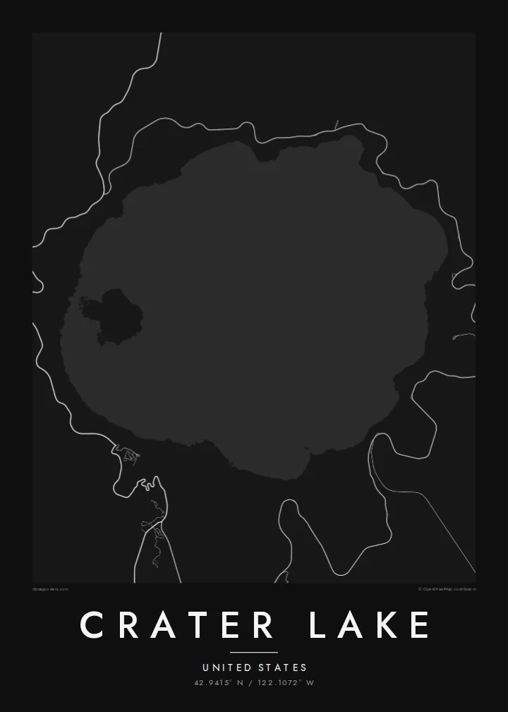
A volcanic cinder cone near the western shore that rises above the water with a small crater at its top, clearly visible as a round mark on the map.
Poster peta minimalis · Amerika Serikat
42.9415° N / 122.1072° W
A near-perfect circle of deep water inside a collapsed volcano, with a small cinder cone island near its western rim



Satu kota, lima nuansa
Ketuk salah satu gaya untuk melihatnya di dinding. Semua gaya harganya sama — baik cetak, berbingkai, maupun file HD.
 Piksel asli · file cetak 24 × 36″
Tajam saat dicetak
Ini adalah crop 100% dari file cetak asli. Setiap poster — dicetak, berbingkai, atau diunduh — dirender di server kami dengan 300 DPI, hingga 7,200 × 10,800 piksel, sehingga jalan sekecil apa pun tetap tajam pada cetakan 24 × 36″.
Di dinding


Peta
Crater Lake fills the caldera left when Mount Mazama collapsed after a major eruption about 7,700 years ago. From above it is almost circular, enclosed by steep caldera walls, with no rivers flowing in or out. It is fed by rain and snow, which is one reason its water is so clear.
It is the deepest lake in the United States, reaching roughly 590 metres. Near the western shore, Wizard Island rises as a cone with its own small summit crater, and to the southeast the small rock formation called Phantom Ship sits low on the water. Rim Drive traces a loop around the caldera edge.
A Crater Lake map poster is one of the most geometric lake maps you can hang. The round basin, the ring road hugging the rim and the single island produce a composition that feels almost designed. Crater Lake National Park, Oregon's only national park, surrounds it with open forest, so the lines outside the caldera stay sparse.
A volcanic cinder cone near the western shore that rises above the water with a small crater at its top, clearly visible as a round mark on the map.
A scenic road follows the caldera rim around the lake, drawing a loop that frames the water like a border.
With no inflowing or outflowing rivers, the lake is a closed circle, its edge defined entirely by the steep walls of the collapsed volcano.
Jadikan milik Anda
Tambahkan tanggal, nama, atau kalimat Anda sendiri, lalu ganti gaya, ukuran, atau orientasi.
Pratinjau gratis beresolusi rendah dan berwatermark. Cetakan dan file HD dirender dengan 300 DPI, hingga 7,200 × 10,800 px, tanpa watermark.
Mengapa Crater Lake
Crater Lake is a stop on many western road trips and a favourite national park for people who have stood on the rim. The round outline makes a strong, symmetrical poster that suits minimalist interiors.
You can personalise the title, subtitle and coordinates, then choose Classic black & white, Noir, Paper, Blueprint or Sand. The $9 digital pack includes 18×24″ and 24×36″ among six sizes, or order a matte print with an optional wooden frame.
Pesan poster Crater Lake| Ukuran cetak | Resolusi | File |
|---|---|---|
| 30 × 40 cm11.8 × 15.7″ | 3,543 × 4,724 px | PNG · PDF |
| 29.7 × 42 cm (A3)11.7 × 16.5″ | 3,508 × 4,961 px | PNG · PDF |
| 42 × 59.4 cm (A2)16.5 × 23.4″ | 4,961 × 7,016 px | PNG · PDF |
| 45.7 × 61 cm18 × 24″ | 5,400 × 7,200 px | PNG · PDF |
| 50 × 70 cm19.7 × 27.6″ | 5,906 × 8,268 px | PNG · PDF |
| 61 × 91.4 cm24 × 36″ | 7,200 × 10,800 px | PNG · PDF |
Sebagai perbandingan, pratinjau gratis lebarnya 900 px, bertanda watermark, dan ditujukan untuk layar. File HD memiliki resolusi hingga 8× lebih besar di setiap sisi dan tercetak jernih dalam ukuran poster penuh.
Pilih gaya di bagian atas halaman, lalu pilih Poster Cetak — beserta ukuran dan, jika suka, bingkai — atau File Digital HD. Checkout hanya satu langkah, dan halaman pesanan Anda langsung diperbarui begitu pembayaran berhasil.
Dicetak di atas kertas doff premium 200 gsm dalam salah satu dari enam ukuran, mulai dari 30 × 40 cm hingga 24 × 36″. Poster cetak mulai dari $39, sudah termasuk ongkos kirim.
Tentu. Pilih bingkai kayu solid berwarna hitam, putih, oak natural, atau kayu gelap. Dilengkapi kaca anti pecah dan siap digantung. Poster berbingkai mulai dari $99, sudah termasuk ongkos kirim.
Gratis ongkir ke 60+ negara. Setiap poster dicetak oleh mitra cetak terdekat kami di 30+ negara dan biasanya tiba dalam 3–7 hari kerja. Anda bisa memantau status dan pelacakan di Pesanan Saya. Beberapa negara membutuhkan waktu 2–5 minggu, dan jika kami belum mengirim ke negara Anda, situs akan memberi tahu sebelum Anda membayar.
Kirimkan foto kepada kami dalam 14 hari sejak pengiriman diterima, dan kami akan mencetak ulang secara gratis atau mengembalikan uang Anda.
Tentu. Di editor pada halaman ini, ubah judul, subjudul, dan baris koordinat sesuai keinginan Anda, lalu pilih gaya dan ukuran. Pesanan cetak, berbingkai, maupun digital semuanya menggunakan desain Anda persis.
Dengan $9 Anda mendapatkan file PNG 300 DPI dan PDF siap cetak dalam keenam ukuran, tanpa watermark, untuk dicetak di mana saja. Belum yakin? Unduh dulu pratinjau gratis berwatermark.
