Port Vila lagoons
Around the capital, lagoons push inland between streets and headlands. On the poster they create a delicate pattern of water and land at the island's southwest corner.
Poster peta minimalis · Vanuatu
17.6739° S / 168.3762° E
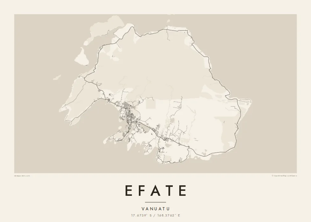
A rounded tropical island ringed by one coastal road, with Port Vila's harbour and lagoons tucked into its southwest corner.




Satu kota, lima nuansa
Ketuk salah satu gaya untuk melihatnya di dinding. Semua gaya harganya sama — baik cetak, berbingkai, maupun file HD.
 Piksel asli · file cetak 24 × 36″
Tajam saat dicetak
Ini adalah crop 100% dari file cetak asli. Setiap poster — dicetak, berbingkai, atau diunduh — dirender di server kami dengan 300 DPI, hingga 7,200 × 10,800 piksel, sehingga jalan sekecil apa pun tetap tajam pada cetakan 24 × 36″.
Di dinding


Peta
Efate is the most populous island of Vanuatu and home to its capital, Port Vila. Its outline is compact and rounded, broken by several large bays and harbours, while the interior is hilly and forested. A sealed ring road follows the coast all the way around the island, linking villages, plantations and beaches in a single loop that shows clearly on the map.
Port Vila spreads along a sheltered harbour on the southwest coast, beside Mele Bay and a series of lagoons, including Erakor and Emten, that reach deep into the town. To the northwest, Havannah Harbour served as a naval anchorage during the Second World War. Chief Roi Mata's Domain, a UNESCO World Heritage site, lies on Efate and the nearby islands of Lelepa and Artok.
An Efate map poster pairs the small, intricate street network of the capital with the long, simple sweep of the ring road. Offshore islands scatter around the coast, and the lagoons around Port Vila add softer, rounded shapes to the composition. It is a map of a capital city and of a quiet island at the same time.
Around the capital, lagoons push inland between streets and headlands. On the poster they create a delicate pattern of water and land at the island's southwest corner.
A single road circles the whole island near the coast. It forms a continuous loop on the map, tying together the capital and the villages along the shore.
A broad, sheltered stretch of water on the northwest coast, protected by offshore islands. It gives the island's outline one of its most distinctive indentations.
Jadikan milik Anda
Tambahkan tanggal, nama, atau kalimat Anda sendiri, lalu ganti gaya, ukuran, atau orientasi.
Pratinjau gratis beresolusi rendah dan berwatermark. Cetakan dan file HD dirender dengan 300 DPI, hingga 7,200 × 10,800 px, tanpa watermark.
Mengapa Efate
Efate is home to many families in Vanuatu and a place of posting or long stays for others, from aid workers to sailors. A poster of the island captures the capital and its surroundings in one clear shape, easy to recognise from across a room.
You can personalise the title and subtitle, add a date or a neighbourhood, and set the coordinates line. Five styles are available: Classic black & white, Noir, Paper, Blueprint and Sand. Printed posters are shipped from partners in more than 30 countries.
Pesan poster Efate| Ukuran cetak | Resolusi | File |
|---|---|---|
| 30 × 40 cm (11.8 × 15.7″) | 3,543 × 4,724 px | PNG · PDF |
| 29.7 × 42 cm (A3, 11.7 × 16.5″) | 3,508 × 4,961 px | PNG · PDF |
| 42 × 59.4 cm (A2, 16.5 × 23.4″) | 4,961 × 7,016 px | PNG · PDF |
| 45.7 × 61 cm (18 × 24″) | 5,400 × 7,200 px | PNG · PDF |
| 50 × 70 cm (19.7 × 27.6″) | 5,906 × 8,268 px | PNG · PDF |
| 61 × 91.4 cm (24 × 36″) | 7,200 × 10,800 px | PNG · PDF |
Sebagai perbandingan, pratinjau gratis lebarnya 900 px, bertanda watermark, dan ditujukan untuk layar. File HD memiliki resolusi hingga 8× lebih besar di setiap sisi dan tercetak jernih dalam ukuran poster penuh.
Pilih gaya di bagian atas halaman, lalu pilih Poster Cetak — beserta ukuran dan, jika suka, bingkai — atau File Digital HD. Checkout hanya satu langkah, dan halaman pesanan Anda langsung diperbarui begitu pembayaran berhasil.
Dicetak di atas kertas doff premium 200 gsm dalam salah satu dari enam ukuran, mulai dari 30 × 40 cm hingga 24 × 36″. Poster cetak mulai dari {printFrom}, sudah termasuk ongkos kirim.
Tentu. Pilih bingkai kayu solid berwarna hitam, putih, oak natural, atau kayu gelap. Dilengkapi kaca anti pecah dan siap digantung. Poster berbingkai mulai dari {framedFrom}, sudah termasuk ongkos kirim.
Pengiriman gratis ke seluruh dunia. Setiap poster dicetak oleh mitra cetak kami terdekat di lebih dari 30 negara dan biasanya tiba dalam 3–7 hari kerja. Anda bisa memantau status dan nomor lacaknya di Pesanan Saya.
Kirimkan foto kepada kami dalam 14 hari sejak pengiriman diterima, dan kami akan mencetak ulang secara gratis atau mengembalikan uang Anda.
Tentu. Di editor pada halaman ini, ubah judul, subjudul, dan baris koordinat sesuai keinginan Anda, lalu pilih gaya dan ukuran. Pesanan cetak, berbingkai, maupun digital semuanya menggunakan desain Anda persis.
Dengan $9 Anda mendapatkan file PNG 300 DPI dan PDF siap cetak dalam keenam ukuran, tanpa watermark, untuk dicetak di mana saja. Belum yakin? Unduh dulu pratinjau gratis berwatermark.
