Numbered grid
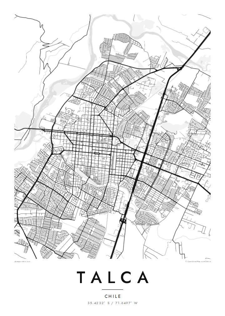
Streets are named by number and direction from the centre, creating a perfectly regular grid that stands out clearly on the map.
Poster peta minimalis · Cile
35.4232° S / 71.6497° W
A colonial grid city in Chile's Central Valley, bounded by the Claro River and surrounded by vineyards and orchards.


Satu kota, lima nuansa
Ketuk salah satu gaya untuk melihatnya di dinding. Semua gaya harganya sama — baik cetak, berbingkai, maupun file HD.
 Piksel asli · file cetak 24 × 36″
Tajam saat dicetak
Ini adalah crop 100% dari file cetak asli. Setiap poster — dicetak, berbingkai, atau diunduh — dirender di server kami dengan 300 DPI, hingga 7,200 × 10,800 piksel, sehingga jalan sekecil apa pun tetap tajam pada cetakan 24 × 36″.
Di dinding


Peta
Talca lies in the Central Valley of Chile, south of Santiago, and is the capital of the Maule Region. It was founded in the eighteenth century on a Spanish colonial plan, and its centre still follows a strict grid of square blocks around a main plaza. Streets are numbered by direction, oriente, poniente, norte and sur, so the map reads almost like a coordinate system.
To the west, the Claro River runs past the edge of the city, and to the east the Andes rise in the distance. Newer districts extend across the flat valley floor, with larger blocks and curving streets beyond the original grid. Around Talca, vineyards and orchards cover the land, part of one of Chile's main wine-growing areas.
Talca holds a special place in Chilean history: Bernardo O'Higgins signed the Act of Independence here in 1818. The city was badly damaged by the 2010 earthquake and has been rebuilding since. A Talca map poster highlights the clarity of its plan, a grid so regular that each street name tells you exactly where you stand.
Streets are named by number and direction from the centre, creating a perfectly regular grid that stands out clearly on the map.
The river runs along the western side of the city, drawing a natural boundary that contrasts with the straight streets beside it.
The main square sits at the heart of the grid, the point from which the city was laid out and still the centre of its street system.
Jadikan milik Anda
Tambahkan tanggal, nama, atau kalimat Anda sendiri, lalu ganti gaya, ukuran, atau orientasi.
Pratinjau gratis beresolusi rendah dan berwatermark. Cetakan dan file HD dirender dengan 300 DPI, hingga 7,200 × 10,800 px, tanpa watermark.
Mengapa Talca
Talca suits people from the Maule Region, students of its universities and anyone who has travelled through Chile's wine country. The regular grid gives the print a calm, orderly look that fits almost any room.
Enter a title, add a subtitle with a date or name and edit the coordinates line. Choose Classic black & white, Noir, Paper, Blueprint or Sand, and get HD files for $9 or a printed poster with an optional wooden frame.
Pesan poster Talca| Ukuran cetak | Resolusi | File |
|---|---|---|
| 30 × 40 cm (11.8 × 15.7″) | 3,543 × 4,724 px | PNG · PDF |
| 29.7 × 42 cm (A3, 11.7 × 16.5″) | 3,508 × 4,961 px | PNG · PDF |
| 42 × 59.4 cm (A2, 16.5 × 23.4″) | 4,961 × 7,016 px | PNG · PDF |
| 45.7 × 61 cm (18 × 24″) | 5,400 × 7,200 px | PNG · PDF |
| 50 × 70 cm (19.7 × 27.6″) | 5,906 × 8,268 px | PNG · PDF |
| 61 × 91.4 cm (24 × 36″) | 7,200 × 10,800 px | PNG · PDF |
Sebagai perbandingan, pratinjau gratis lebarnya 900 px, bertanda watermark, dan ditujukan untuk layar. File HD memiliki resolusi hingga 8× lebih besar di setiap sisi dan tercetak jernih dalam ukuran poster penuh.
Pilih gaya di bagian atas halaman, lalu pilih Poster Cetak — beserta ukuran dan, jika suka, bingkai — atau File Digital HD. Checkout hanya satu langkah, dan halaman pesanan Anda langsung diperbarui begitu pembayaran berhasil.
Dicetak di atas kertas doff premium 200 gsm dalam salah satu dari enam ukuran, mulai dari 30 × 40 cm hingga 24 × 36″. Poster cetak mulai dari {printFrom}, sudah termasuk ongkos kirim.
Tentu. Pilih bingkai kayu solid berwarna hitam, putih, oak natural, atau kayu gelap. Dilengkapi kaca anti pecah dan siap digantung. Poster berbingkai mulai dari {framedFrom}, sudah termasuk ongkos kirim.
Pengiriman gratis ke seluruh dunia. Setiap poster dicetak oleh mitra cetak terdekat kami di 30+ negara dan biasanya tiba dalam 3–7 hari kerja. Status dan pelacakan pesanan bisa dipantau di Pesanan Saya. Beberapa negara memerlukan waktu 2–5 minggu, dan jika kami belum melayani pengiriman ke negara Anda, situs akan memberi tahu sebelum Anda membayar.
Kirimkan foto kepada kami dalam 14 hari sejak pengiriman diterima, dan kami akan mencetak ulang secara gratis atau mengembalikan uang Anda.
Tentu. Di editor pada halaman ini, ubah judul, subjudul, dan baris koordinat sesuai keinginan Anda, lalu pilih gaya dan ukuran. Pesanan cetak, berbingkai, maupun digital semuanya menggunakan desain Anda persis.
Dengan $9 Anda mendapatkan file PNG 300 DPI dan PDF siap cetak dalam keenam ukuran, tanpa watermark, untuk dicetak di mana saja. Belum yakin? Unduh dulu pratinjau gratis berwatermark.
