The Ukhta River
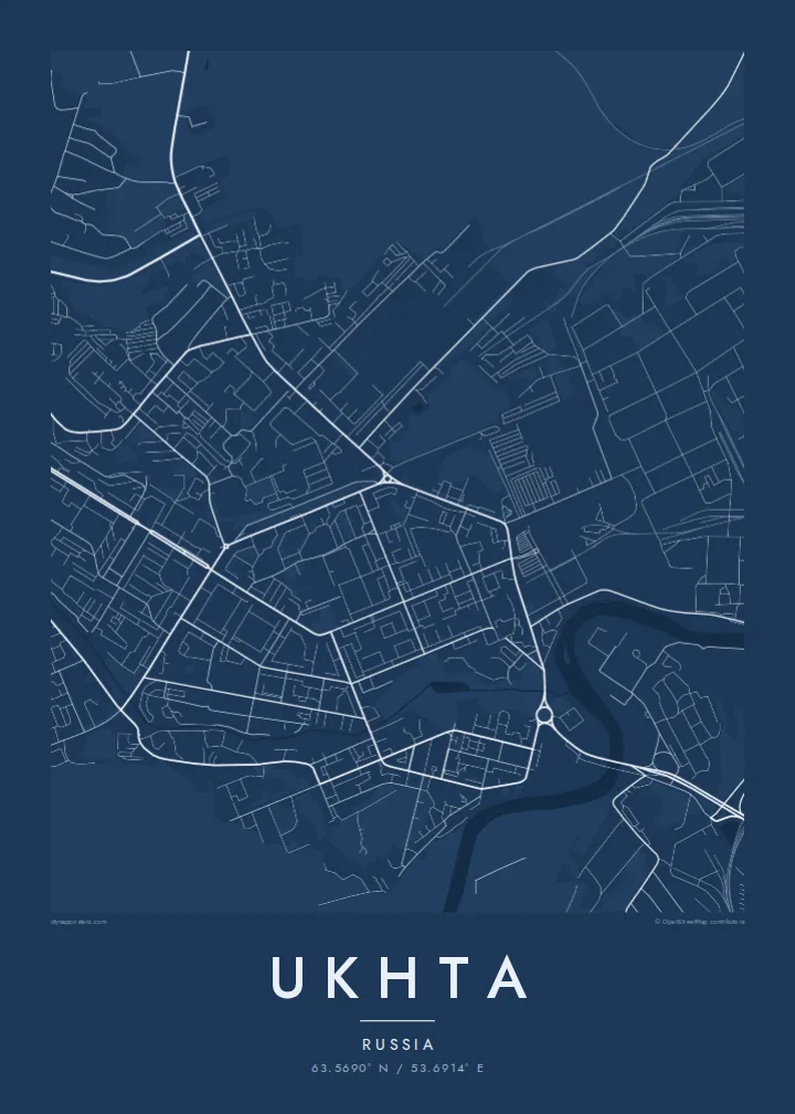
The river loops through the city from end to end, and most districts are arranged along its banks, which gives the map its long, winding shape.
Poster peta minimalis · Rusia
63.5690° N / 53.6914° E
A northern oil town strung along the winding Ukhta River, its districts spread across forested low hills of the Komi Republic.



Satu kota, lima nuansa
Ketuk salah satu gaya untuk melihatnya di dinding. Semua gaya harganya sama — baik cetak, berbingkai, maupun file HD.
 Piksel asli · file cetak 24 × 36″
Tajam saat dicetak
Ini adalah crop 100% dari file cetak asli. Setiap poster — dicetak, berbingkai, atau diunduh — dirender di server kami dengan 300 DPI, hingga 7,200 × 10,800 piksel, sehingga jalan sekecil apa pun tetap tajam pada cetakan 24 × 36″.
Di dinding


Peta
Ukhta sits in the Komi Republic in Russia's European north, in taiga country near the Timan Ridge. The city follows the Ukhta River, which winds through a wooded valley. On the map, districts line the river's bends and climb the low hills on either side, so the city looks stretched and branched rather than round.
Oil is the reason the city exists. Oil seeps along the Ukhta River were noted centuries ago. The modern town grew in the 1930s, when the area was developed by the labour camp system, and oil and gas have shaped its economy ever since. Ukhta is also home to a technical university focused on the petroleum industry.
On an Ukhta map poster, the street grids of the Soviet-era centre stand out as regular blocks laid across a landscape of curves: river bends, forest edges and roads following the terrain. Separate industrial and residential districts appear as distinct islands connected by long roads through the forest.
The river loops through the city from end to end, and most districts are arranged along its banks, which gives the map its long, winding shape.
The central districts follow a planned grid of broad streets and large residential blocks, the most geometric part of the plan.
Neighbourhoods and industrial sites are separated by taiga, so the map shows several clusters linked by roads rather than one continuous city.
Jadikan milik Anda
Tambahkan tanggal, nama, atau kalimat Anda sendiri, lalu ganti gaya, ukuran, atau orientasi.
Pratinjau gratis beresolusi rendah dan berwatermark. Cetakan dan file HD dirender dengan 300 DPI, hingga 7,200 × 10,800 px, tanpa watermark.
Mengapa Ukhta
Many people who worked in the northern oil and gas industry or studied in Ukhta have since moved elsewhere. This map holds the shape of a city built in hard conditions in the northern forest.
Personalise the title and subtitle, perhaps with a graduation year or the years you lived there, and include the coordinates line if you like. Choose from Classic black & white, Noir, Paper, Blueprint and Sand.
Pesan poster Ukhta| Ukuran cetak | Resolusi | File |
|---|---|---|
| 30 × 40 cm (11.8 × 15.7″) | 3,543 × 4,724 px | PNG · PDF |
| 29.7 × 42 cm (A3, 11.7 × 16.5″) | 3,508 × 4,961 px | PNG · PDF |
| 42 × 59.4 cm (A2, 16.5 × 23.4″) | 4,961 × 7,016 px | PNG · PDF |
| 45.7 × 61 cm (18 × 24″) | 5,400 × 7,200 px | PNG · PDF |
| 50 × 70 cm (19.7 × 27.6″) | 5,906 × 8,268 px | PNG · PDF |
| 61 × 91.4 cm (24 × 36″) | 7,200 × 10,800 px | PNG · PDF |
Sebagai perbandingan, pratinjau gratis lebarnya 900 px, bertanda watermark, dan ditujukan untuk layar. File HD memiliki resolusi hingga 8× lebih besar di setiap sisi dan tercetak jernih dalam ukuran poster penuh.
Pilih gaya di bagian atas halaman, lalu pilih Poster Cetak — beserta ukuran dan, jika suka, bingkai — atau File Digital HD. Checkout hanya satu langkah, dan halaman pesanan Anda langsung diperbarui begitu pembayaran berhasil.
Dicetak di atas kertas doff premium 200 gsm dalam salah satu dari enam ukuran, mulai dari 30 × 40 cm hingga 24 × 36″. Poster cetak mulai dari $39, sudah termasuk ongkos kirim.
Tentu. Pilih bingkai kayu solid berwarna hitam, putih, oak natural, atau kayu gelap. Dilengkapi kaca anti pecah dan siap digantung. Poster berbingkai mulai dari $99, sudah termasuk ongkos kirim.
Pengiriman gratis ke seluruh dunia. Setiap poster dicetak oleh mitra cetak terdekat kami di 30+ negara dan biasanya tiba dalam 3–7 hari kerja. Status dan pelacakan pesanan bisa dipantau di Pesanan Saya. Beberapa negara memerlukan waktu 2–5 minggu, dan jika kami belum melayani pengiriman ke negara Anda, situs akan memberi tahu sebelum Anda membayar.
Kirimkan foto kepada kami dalam 14 hari sejak pengiriman diterima, dan kami akan mencetak ulang secara gratis atau mengembalikan uang Anda.
Tentu. Di editor pada halaman ini, ubah judul, subjudul, dan baris koordinat sesuai keinginan Anda, lalu pilih gaya dan ukuran. Pesanan cetak, berbingkai, maupun digital semuanya menggunakan desain Anda persis.
Dengan $9 Anda mendapatkan file PNG 300 DPI dan PDF siap cetak dalam keenam ukuran, tanpa watermark, untuk dicetak di mana saja. Belum yakin? Unduh dulu pratinjau gratis berwatermark.
