The Mahakali River
The broad braided river along the western edge forms the international border. Its channels and sandbars give the map a loose, shifting edge instead of a hard line.
Minimalískt kortaplakat · Nepal
28.9640° N / 80.1771° E
A flat Terai town at Nepal's far-western edge, set between the Mahakali River, forest reserves and the first ridges of hills.


Ein borg, fimm stemningar
Ýttu á stíl til að sjá hann á veggnum. Allir stílar kosta það sama — prentaðir, innrammaðir eða sem HD skrár.
 Raunstærð í pixlum · 24 × 36″ prentskrá
Skarpt í prentun
Þetta er 100% útklipping úr raunverulegu prentskránni. Hvert plakat — prentað, innrammað eða niðurhalað — er unnið á netþjónum okkar í 300 DPI, allt að 7,200 × 10,800 pixlum, svo jafnvel minnstu göturnar haldast skarpar á 24 × 36″ prenti.
Á veggnum


Kortið
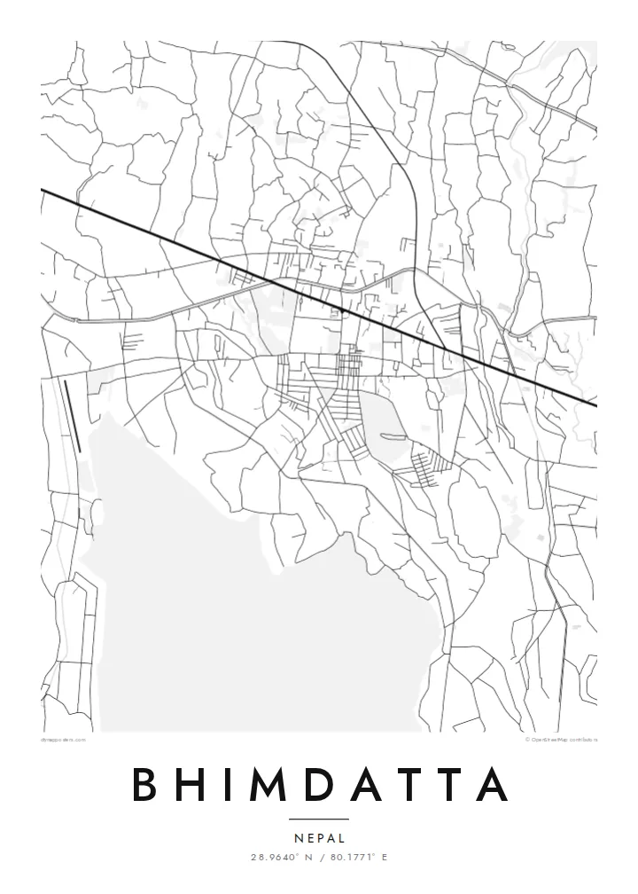
Bhimdatta, long known as Mahendranagar, is the main town of Kanchanpur District in Sudurpashchim Pradesh, in the far west of Nepal. It sits on the level plain of the Terai, close to the border with India. The flat ground shows on a map. Streets spread across open land without the switchbacks of hill towns, and the edges run out into fields, irrigation channels and patches of forest.
The Mahakali River, which marks this stretch of the border between Nepal and India, runs just west of the town. It sets the western limit of the map. Across it is the Indian town of Banbasa, and the crossing between them is one of the busiest in western Nepal. To the south lies Shuklaphanta National Park, a wide area of grassland and forest that appears on a Bhimdatta map poster as a large, quiet space.
The town was renamed in honour of Bhimdatta Panta, a twentieth-century activist remembered for his campaigns for farmers' rights in the far west. It is also near the western end of the Mahendra Highway, the east–west route that crosses the country's lowland belt. That road ties Bhimdatta to the rest of Nepal, so the town reads as a western terminus as well as a border town.
The broad braided river along the western edge forms the international border. Its channels and sandbars give the map a loose, shifting edge instead of a hard line.
The national park south of town is a large expanse of grassland and forest with almost no streets. On the poster it becomes a calm open area next to the urban blocks.
The Mahendra Highway reaches this corner of the country after crossing the lowlands from the east. On the map it is the long straight line that anchors the town.
Gerðu það að þínu
Bættu við dagsetningu, nafni eða eigin texta, skiptu um stíl, stærð eða stefnu.
Ókeypis forskoðunin er í lágri upplausn með vatnsmerki. Prentanir og HD skrár eru unnar í 300 DPI, allt að 7,200 × 10,800 px, án vatnsmerkis.
Af hverju Bhimdatta
For people from Kanchanpur, or those who have crossed the border here or travelled Nepal's lowland highway to its western end, this map marks a real point of arrival. The flat plain, the river and the reserve make a clear, balanced composition on a wall.
You can edit the title, subtitle and coordinates, for example to use Mahendranagar, the older name, or a date that matters to you. Then pick one of five styles: Classic black and white, Noir, Paper, Blueprint or Sand.
Panta Bhimdatta plakatið| Prentstærð | Upplausn | Skrár |
|---|---|---|
| 30 × 40 cm11.8 × 15.7″ | 3,543 × 4,724 px | PNG · PDF |
| 29.7 × 42 cm (A3)11.7 × 16.5″ | 3,508 × 4,961 px | PNG · PDF |
| 42 × 59.4 cm (A2)16.5 × 23.4″ | 4,961 × 7,016 px | PNG · PDF |
| 45.7 × 61 cm18 × 24″ | 5,400 × 7,200 px | PNG · PDF |
| 50 × 70 cm19.7 × 27.6″ | 5,906 × 8,268 px | PNG · PDF |
| 61 × 91.4 cm24 × 36″ | 7,200 × 10,800 px | PNG · PDF |
Til samanburðar er ókeypis forskoðunin 900 px á breidd, með vatnsmerki og ætluð fyrir skjái. HD-skrárnar eru með allt að 8× meiri upplausn í hvora átt og prentast hreint í fullri plakatstærð.
Veldu stíl efst á síðunni og veldu síðan Prentað plakat — stærð og ramma ef þú vilt — eða Stafrænar HD skrár. Greiðsluferlið tekur eitt skref og pöntunarsíðan þín uppfærist um leið og greiðslan gengur í gegn.
Það er prentað á vandaðan 200 g/m² mattan pappír í einni af sex stærðum, frá 30 × 40 cm upp í 24 × 36″. Prentuð plaköt kosta frá $39, með sendingu innifalinni.
Já. Veldu ramma úr massífum við í svörtu, hvítu, náttúrulegri eik eða dökkum viði. Hann kemur með höggheldu gleri og er tilbúinn til að hengja upp. Innrömmuð plaköt kosta frá $99, með sendingu innifalinni.
Sendingin er ókeypis til 60+ landa. Hvert veggspjald er prentað hjá næsta prentsamstarfsaðila okkar í 30+ löndum og berst venjulega á 3–7 virkum dögum. Þú getur fylgst með stöðu og rakningu undir Mínar pantanir. Í sumum löndum tekur það 2–5 vikur og ef við sendum ekki enn til þíns lands lætur vefurinn þig vita áður en þú greiðir.
Sendu okkur mynd innan 14 daga frá afhendingu og við prentum það aftur ókeypis eða endurgreiðum þér.
Já. Í ritlinum á þessari síðu getur þú breytt titlinum, undirtitlinum og hnitalínunni í hvað sem þú vilt, og valið stíl og stærð. Prentaðar, innrammaðar og stafrænar pantanir nota allar nákvæmlega þína hönnun.
Fyrir $9 færðu 300 DPI PNG og prentunartilbúnar PDF skrár í öllum sex stærðum, án vatnsmerkis, til að prenta hvar sem er. Ekki alveg viss? Náðu fyrst í ókeypis forskoðun með vatnsmerki.
