Former lakebed
The city sits on the dried bed of Lake Chalco. The flat ground allowed long, straight street grids to be laid out.
Minimalískt kortaplakat · Mexíkó
19.2617° N / 98.8978° W
A city on the dry bed of a former lake in the Valley of Mexico, with volcanoes rising to the east


Ein borg, fimm stemningar
Ýttu á stíl til að sjá hann á veggnum. Allir stílar kosta það sama — prentaðir, innrammaðir eða sem HD skrár.
 Raunstærð í pixlum · 24 × 36″ prentskrá
Skarpt í prentun
Þetta er 100% útklipping úr raunverulegu prentskránni. Hvert plakat — prentað, innrammað eða niðurhalað — er unnið á netþjónum okkar í 300 DPI, allt að 7,200 × 10,800 pixlum, svo jafnvel minnstu göturnar haldast skarpar á 24 × 36″ prenti.
Á veggnum


Kortið
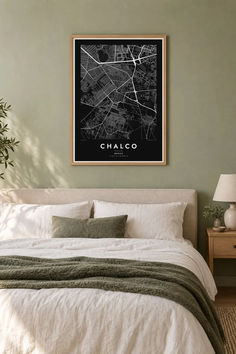
Chalco lies in the southeast of the Valley of Mexico, in the State of México, on land that was once the bed of Lake Chalco. The lake was one of the five connected lakes in the valley before the Spanish conquest, and it was gradually drained over several centuries. The flat terrain it left behind is the base for the city's streets today.
On a map, Chalco's older centre forms a small cluster within a much wider urban area that has grown rapidly in recent decades, merging with neighbouring municipalities. The land is almost completely flat, so the new streets follow long, straight grids. East of the city, the ground rises toward the volcanoes Iztaccíhuatl and Popocatépetl.
A Chalco map poster shows the flat grid of the former lakebed, the older town at its heart, and the main highways connecting it to Mexico City. The regular pattern tells the story of a lake turned into land and then into city. It is a thoughtful choice for anyone whose family history is tied to this part of the valley.
The city sits on the dried bed of Lake Chalco. The flat ground allowed long, straight street grids to be laid out.
The older town forms a small, compact core within the much larger urban area that has grown up around it.
Highways lead east, where the land rises toward Iztaccíhuatl and Popocatépetl. The terrain on that side of the map becomes less regular.
Gerðu það að þínu
Bættu við dagsetningu, nafni eða eigin texta, skiptu um stíl, stærð eða stefnu.
Ókeypis forskoðunin er í lágri upplausn með vatnsmerki. Prentanir og HD skrár eru unnar í 300 DPI, allt að 7,200 × 10,800 px, án vatnsmerkis.
Af hverju Chalco
Chalco is home to a large community with deep ties to the Valley of Mexico. Its map shows how the city grew from a small town on the lakeshore into a large urban area on the former lakebed.
You can add a title, a subtitle with a family name or date, and the coordinates. Choose one of five styles: Classic black & white, Noir, Paper, Blueprint or Sand. Blueprint suits the straight lines of the former lakebed grid.
Panta Chalco plakatið| Prentstærð | Upplausn | Skrár |
|---|---|---|
| 30 × 40 cm (11.8 × 15.7″) | 3,543 × 4,724 px | PNG · PDF |
| 29.7 × 42 cm (A3, 11.7 × 16.5″) | 3,508 × 4,961 px | PNG · PDF |
| 42 × 59.4 cm (A2, 16.5 × 23.4″) | 4,961 × 7,016 px | PNG · PDF |
| 45.7 × 61 cm (18 × 24″) | 5,400 × 7,200 px | PNG · PDF |
| 50 × 70 cm (19.7 × 27.6″) | 5,906 × 8,268 px | PNG · PDF |
| 61 × 91.4 cm (24 × 36″) | 7,200 × 10,800 px | PNG · PDF |
Til samanburðar er ókeypis forskoðunin 900 px á breidd, með vatnsmerki og ætluð fyrir skjái. HD-skrárnar eru með allt að 8× meiri upplausn í hvora átt og prentast hreint í fullri plakatstærð.
Veldu stíl efst á síðunni og veldu síðan Prentað plakat — stærð og ramma ef þú vilt — eða Stafrænar HD skrár. Greiðsluferlið tekur eitt skref og pöntunarsíðan þín uppfærist um leið og greiðslan gengur í gegn.
Það er prentað á vandaðan 200 g/m² mattan pappír í einni af sex stærðum, frá 30 × 40 cm upp í 24 × 36″. Prentuð plaköt kosta frá {printFrom}, með sendingu innifalinni.
Já. Veldu ramma úr massífum við í svörtu, hvítu, náttúrulegri eik eða dökkum viði. Hann kemur með höggheldu gleri og er tilbúinn til að hengja upp. Innrömmuð plaköt kosta frá {framedFrom}, með sendingu innifalinni.
Frí sending um allan heim. Hvert plakat er prentað hjá næsta prentsamstarfsaðila okkar í yfir 30 löndum og berst yfirleitt innan 3–7 virkra daga. Þú getur fylgst með stöðu og rakningu undir Pantanirnar mínar. Sums staðar tekur sendingin 2–5 vikur og ef við sendum ekki enn þangað lætur vefurinn þig vita áður en þú greiðir.
Sendu okkur mynd innan 14 daga frá afhendingu og við prentum það aftur ókeypis eða endurgreiðum þér.
Já. Í ritlinum á þessari síðu getur þú breytt titlinum, undirtitlinum og hnitalínunni í hvað sem þú vilt, og valið stíl og stærð. Prentaðar, innrammaðar og stafrænar pantanir nota allar nákvæmlega þína hönnun.
Fyrir $9 færðu 300 DPI PNG og prentunartilbúnar PDF skrár í öllum sex stærðum, án vatnsmerkis, til að prenta hvar sem er. Ekki alveg viss? Náðu fyrst í ókeypis forskoðun með vatnsmerki.
