Colonial checkerboard
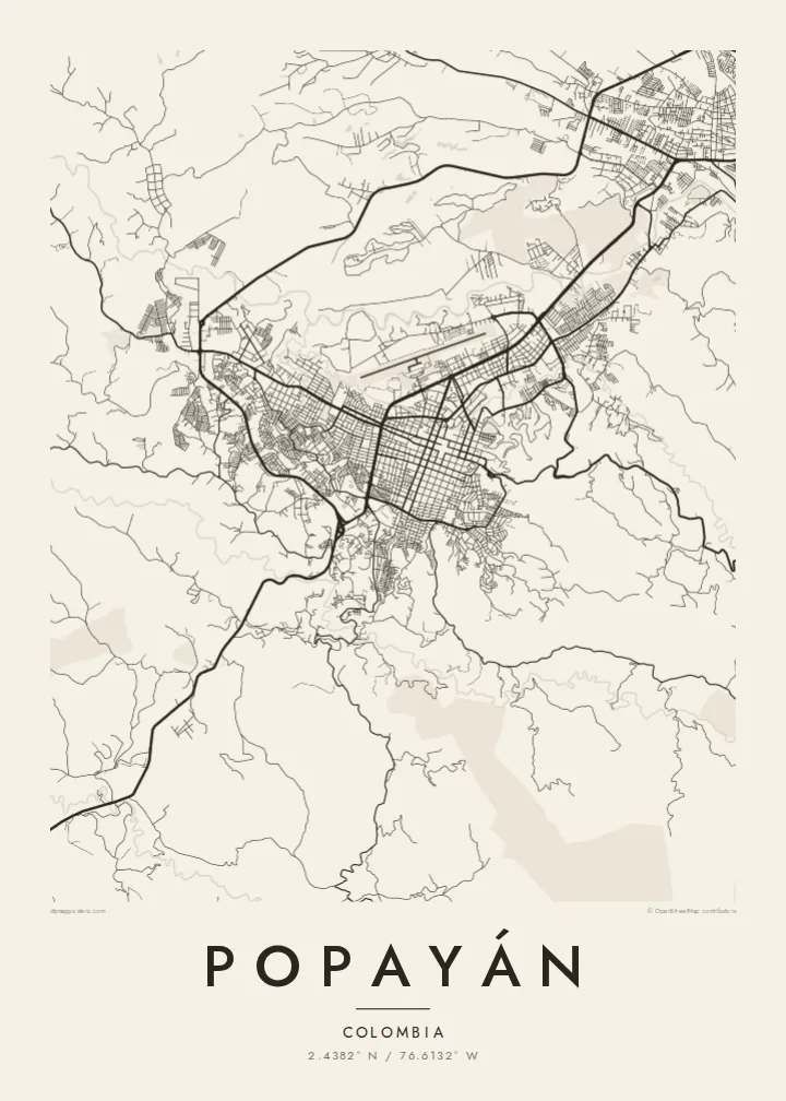
The historic core is laid out in square blocks around the central plaza. It is one of the most complete Spanish grids in Colombia and reads very cleanly in thin black lines.
Minimalískt kortaplakat · Kólumbía
2.4382° N / 76.6132° W
A tight colonial grid of whitewashed blocks at the foot of the Andes, crossed by the Molino River and overlooked by a grassy pyramid hill




Ein borg, fimm stemningar
Ýttu á stíl til að sjá hann á veggnum. Allir stílar kosta það sama — prentaðir, innrammaðir eða sem HD skrár.
 Raunstærð í pixlum · 24 × 36″ prentskrá
Skarpt í prentun
Þetta er 100% útklipping úr raunverulegu prentskránni. Hvert plakat — prentað, innrammað eða niðurhalað — er unnið á netþjónum okkar í 300 DPI, allt að 7,200 × 10,800 pixlum, svo jafnvel minnstu göturnar haldast skarpar á 24 × 36″ prenti.
Á veggnum


Kortið
Popayán sits in a high valley of southwestern Colombia at roughly 1,700 metres, between the Central and Western cordilleras. From above, the historic centre is a clean Spanish checkerboard of square blocks. Beyond it the streets loosen into newer neighbourhoods that follow the folds of the land. The Pan-American Highway runs along the western side of town, a long line that carries traffic between Cali and Ecuador.
Its nickname, the White City, comes from the lime-washed facades of the old centre. You can't see that colour on a monochrome print, but the order behind it shows up clearly: evenly spaced streets, the rectangle of the main square and the regular rhythm of churches and cloisters. A Popayán map poster keeps that colonial geometry and leaves out the noise of the modern road network.
The city is also known for its Holy Week processions, which UNESCO lists as intangible cultural heritage, and for its cooking, which earned it the title of UNESCO City of Gastronomy. Neither shows up on a street plan, but the processions follow the same streets drawn on the poster. For many people who know the city, those streets carry the memory of candlelit nights in April.
The historic core is laid out in square blocks around the central plaza. It is one of the most complete Spanish grids in Colombia and reads very cleanly in thin black lines.
A rounded hill just east of the centre, believed to be a pre-Columbian earthwork pyramid. On the map it appears as a small island of open ground among the city streets.
The Molino River cuts through the northern edge of the old town. Near the old brick Humilladero bridge, the orderly grid meets the river's natural bend.
Gerðu það að þínu
Bættu við dagsetningu, nafni eða eigin texta, skiptu um stíl, stærð eða stefnu.
Ókeypis forskoðunin er í lágri upplausn með vatnsmerki. Prentanir og HD skrár eru unnar í 300 DPI, allt að 7,200 × 10,800 px, án vatnsmerkis.
Af hverju Popayán
People who studied, married or grew up in Popayán often want something quieter than a photograph of the white facades. The street plan gives them the structure of the place without the postcard. It suits a study or a hallway, where a reserved image works better than a bright one.
You can add your own title and a subtitle such as a year, a family name or a date that matters. The coordinates line can mark the old centre or a particular address. Then choose one of five styles, from Classic black and white to the warmer Sand or the technical Blueprint.
Panta Popayán plakatið| Prentstærð | Upplausn | Skrár |
|---|---|---|
| 30 × 40 cm (11.8 × 15.7″) | 3,543 × 4,724 px | PNG · PDF |
| 29.7 × 42 cm (A3, 11.7 × 16.5″) | 3,508 × 4,961 px | PNG · PDF |
| 42 × 59.4 cm (A2, 16.5 × 23.4″) | 4,961 × 7,016 px | PNG · PDF |
| 45.7 × 61 cm (18 × 24″) | 5,400 × 7,200 px | PNG · PDF |
| 50 × 70 cm (19.7 × 27.6″) | 5,906 × 8,268 px | PNG · PDF |
| 61 × 91.4 cm (24 × 36″) | 7,200 × 10,800 px | PNG · PDF |
Til samanburðar er ókeypis forskoðunin 900 px á breidd, með vatnsmerki og ætluð fyrir skjái. HD-skrárnar eru með allt að 8× meiri upplausn í hvora átt og prentast hreint í fullri plakatstærð.
Veldu stíl efst á síðunni og veldu síðan Prentað plakat — stærð og ramma ef þú vilt — eða Stafrænar HD skrár. Greiðsluferlið tekur eitt skref og pöntunarsíðan þín uppfærist um leið og greiðslan gengur í gegn.
Það er prentað á vandaðan 200 g/m² mattan pappír í einni af sex stærðum, frá 30 × 40 cm upp í 24 × 36″. Prentuð plaköt kosta frá $39, með sendingu innifalinni.
Já. Veldu ramma úr massífum við í svörtu, hvítu, náttúrulegri eik eða dökkum viði. Hann kemur með höggheldu gleri og er tilbúinn til að hengja upp. Innrömmuð plaköt kosta frá $99, með sendingu innifalinni.
Frí sending um allan heim. Hvert plakat er prentað hjá næsta prentsamstarfsaðila okkar í yfir 30 löndum og berst yfirleitt innan 3–7 virkra daga. Þú getur fylgst með stöðu og rakningu undir Pantanirnar mínar. Sums staðar tekur sendingin 2–5 vikur og ef við sendum ekki enn þangað lætur vefurinn þig vita áður en þú greiðir.
Sendu okkur mynd innan 14 daga frá afhendingu og við prentum það aftur ókeypis eða endurgreiðum þér.
Já. Í ritlinum á þessari síðu getur þú breytt titlinum, undirtitlinum og hnitalínunni í hvað sem þú vilt, og valið stíl og stærð. Prentaðar, innrammaðar og stafrænar pantanir nota allar nákvæmlega þína hönnun.
Fyrir $9 færðu 300 DPI PNG og prentunartilbúnar PDF skrár í öllum sex stærðum, án vatnsmerkis, til að prenta hvar sem er. Ekki alveg viss? Náðu fyrst í ókeypis forskoðun með vatnsmerki.
