Bago River
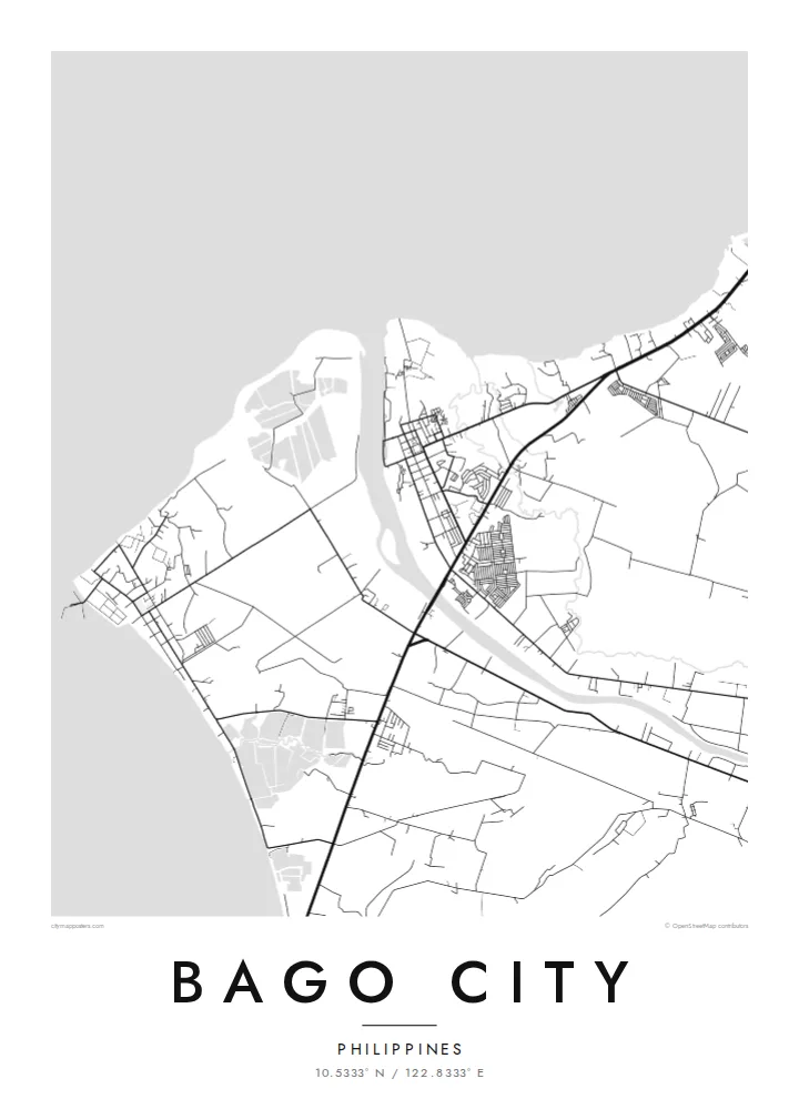
The river crosses the plain from the uplands to the coast, with the town centre close to its banks. On the map it is a clear curving line through the agricultural grid.
Minimalist map poster · Philippines
10.5333° N / 122.8333° E
A sugar city on the coastal plain of Negros, stretching from the Guimaras Strait inland toward the slopes of Kanlaon.


One city, five moods
Ekamowa emwit style ouga bwe ouga ekamowa e dedaña ñan bwega. Style otata a kor eangan — eprint, eframe ke HD files.
 Pixel ekwan · 24 × 36″ print file
Print-sharp
Enin 100% crop eo mai print file eo elango. Poster otata — eprint, eframe ke edownload — erender iaan server bwir e 300 DPI, dedaña ñan 7,200 × 10,800 pixels, bwe lane ekekedik ekwan ebwe crisp iaan print 24 × 36″.
Ituro


The map
Bago City lies on the western side of Negros Island, just south of Bacolod, on a broad plain that rises gently from the Guimaras Strait toward the mountains of the interior. From above, the compact town centre sits near the Bago River, surrounded by an immense pattern of sugarcane fields, farm roads and scattered villages that stretch inland across the city's large territory.
Like much of Negros Occidental, Bago developed around sugar, and cane fields still shape almost every part of the map. The city is the birthplace of General Juan Araneta, a leader of the 1898 revolution on Negros, and to the east its territory reaches toward Mount Kanlaon, the island's highest peak and an active volcano.
A Bago City map poster captures the scale of this landscape: the river winding toward the sea, the town at its banks, the long roads across the plantations and the rising ground in the east. In black and white, the field boundaries and roads form a precise pattern of lines, like a surveyor's drawing.
The river crosses the plain from the uplands to the coast, with the town centre close to its banks. On the map it is a clear curving line through the agricultural grid.
Large plantation fields divided by farm roads cover much of the city's land. From above they create a wide, geometric mosaic that gives the poster its character.
To the west the city reaches the Guimaras Strait, where the plain meets the sea along a low, gently curving shore. It forms a quiet edge to the composition and a counterpoint to the fields.
Make it yours
Add a date, a name or a line of your own, switch style, size or orientation.
Preview ededa low-resolution im watermark. Print im HD files erender iaan 300 DPI, dedaña ñan 7,200 × 10,800 px, ededa watermark.
Why Bago City
For people from Bago City, whether they still live on Negros or work abroad, a map of the town and its fields is a way of keeping home close. It also makes a considered gift for a homecoming, a graduation or a wedding.
Add a title, subtitle and coordinates line with a barangay name or a meaningful date, and choose one of five styles: Classic black & white, Noir, Paper, Blueprint or Sand. Sand pairs naturally with the colours of the cane fields.
Oder poster Bago City| Print size | Resolution | Files |
|---|---|---|
| 30 × 40 cm11.8 × 15.7″ | 3,543 × 4,724 px | PNG · PDF |
| 29.7 × 42 cm (A3)11.7 × 16.5″ | 3,508 × 4,961 px | PNG · PDF |
| 42 × 59.4 cm (A2)16.5 × 23.4″ | 4,961 × 7,016 px | PNG · PDF |
| 45.7 × 61 cm18 × 24″ | 5,400 × 7,200 px | PNG · PDF |
| 50 × 70 cm19.7 × 27.6″ | 5,906 × 8,268 px | PNG · PDF |
| 61 × 91.4 cm24 × 36″ | 7,200 × 10,800 px | PNG · PDF |
For comparison, the free preview is 900 px wide, watermarked and meant for screens. The HD files have up to 8× the resolution in each direction and print cleanly at full poster size.
Emwit style iaan capña page, im dogen Printed Poster — size eo, im framme ouga tomwin — ke Digital HD Files. Checkout eaer sit step, im order page bwira eupdate iaan payment eo emej.
Eprint iaan matte paper 200 gsm, iaan size eo eo, mai 30 × 40 cm ñan 24 × 36″. Poster eprint eo emeja iaan $39, shipping ededo.
Eko. Emwit frame wood solid iaan black, white, oak natural ke wood dark. Etaña shatterproof glazing im ready ñan hang. Poster eframe emeja iaan $99, shipping ededo.
Shipping ma free ägen 60+ country. Poster ngaga eo e print ägen print partner nearest ibiema 30+ country, ae e tep ägen 3–7 business day. Ngaga kor status ae tracking ibe My Orders. Country ibiema e tep 2–5 week, ae country ngaga ibe shipping e bwaren, website e ibin oen bwa ngaga pay.
Kabun photo bwira iaan 14 aean mai delivery, im bwira ereprint ededo ke erefund.
Eko. Iaan editor page eanin, ouga change title, subtitle, im coordinates line ñan tomwin ouga koda, im emwit style im size. Order eprint, eframe im digital otata ekamowa design ouga tomwin.
Iaan $9 ouga ereub 300 DPI PNG im PDF print-ready iaan size otata eo, ededa watermark, ñan print ekamowa tomwin. Ouga aewedik? Download preview ededa watermarked kabun.
