Colonial-era grid
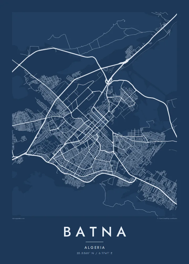
The historic core is laid out in straight streets meeting at right angles, a regular pattern that stands out sharply at the centre of the map.
Minimalist map poster · Algeria
35.5560° N / 6.1741° E
A high plateau city in the Aurès, laid out on a colonial grid, with Roman Timgad and Lambaesis close by



One city, five moods
Ekamowa emwit style ouga bwe ouga ekamowa e dedaña ñan bwega. Style otata a kor eangan — eprint, eframe ke HD files.
 Pixel ekwan · 24 × 36″ print file
Print-sharp
Enin 100% crop eo mai print file eo elango. Poster otata — eprint, eframe ke edownload — erender iaan server bwir e 300 DPI, dedaña ñan 7,200 × 10,800 pixels, bwe lane ekekedik ekwan ebwe crisp iaan print 24 × 36″.
Ituro


The map
Batna stands on a high plateau in northeastern Algeria, around 1,000 metres above sea level, in a basin enclosed by the Aurès mountains. It began in 1844 as a French military camp, and the older centre still keeps the straight, regular streets of that period. Since then the city has spread widely in every direction across the valley floor.
The region around Batna is one of the richest in Roman remains in North Africa. Timgad, a colony founded under Trajan with an almost perfect grid plan, lies to the east. Lambaesis, headquarters of the Third Augustan Legion, is even closer. Batna is also regarded as a cradle of the Algerian War of Independence, which began in the Aurès in 1954.
A Batna map poster draws on that long tradition of planned cities. The regular blocks of the centre, the wide avenues added during the twentieth century and the mountains closing in on the basin make a clear, confident image, with the bare slopes of the Aurès as a quiet frame.
The historic core is laid out in straight streets meeting at right angles, a regular pattern that stands out sharply at the centre of the map.
Ridges and slopes of the Aurès surround the basin. They hold the city within the shape of its valley and leave the edges of the poster open and calm.
Main roads lead east and southeast out of the city toward the Roman sites of Lambaesis and Timgad, whose own grids echo Batna's plan.
Make it yours
Add a date, a name or a line of your own, switch style, size or orientation.
Preview ededa low-resolution im watermark. Print im HD files erender iaan 300 DPI, dedaña ñan 7,200 × 10,800 px, ededa watermark.
Why Batna
For Chaoui families and anyone who grew up in Batna, the city's plan holds memories of school, market and family streets. For others, Batna is the gateway to the Aurès and to some of the finest Roman ruins in North Africa.
Choose a title and subtitle, perhaps with a family name or a date, adjust the coordinates, and select one of five styles, from Paper to Sand. Download the six-size HD package for $9 or have a matte print shipped from partners in 30+ countries.
Oder poster Batna| Print size | Resolution | Files |
|---|---|---|
| 30 × 40 cm (11.8 × 15.7″) | 3,543 × 4,724 px | PNG · PDF |
| 29.7 × 42 cm (A3, 11.7 × 16.5″) | 3,508 × 4,961 px | PNG · PDF |
| 42 × 59.4 cm (A2, 16.5 × 23.4″) | 4,961 × 7,016 px | PNG · PDF |
| 45.7 × 61 cm (18 × 24″) | 5,400 × 7,200 px | PNG · PDF |
| 50 × 70 cm (19.7 × 27.6″) | 5,906 × 8,268 px | PNG · PDF |
| 61 × 91.4 cm (24 × 36″) | 7,200 × 10,800 px | PNG · PDF |
For comparison, the free preview is 900 px wide, watermarked and meant for screens. The HD files have up to 8× the resolution in each direction and print cleanly at full poster size.
Emwit style iaan capña page, im dogen Printed Poster — size eo, im framme ouga tomwin — ke Digital HD Files. Checkout eaer sit step, im order page bwira eupdate iaan payment eo emej.
Eprint iaan matte paper 200 gsm, iaan size eo eo, mai 30 × 40 cm ñan 24 × 36″. Poster eprint eo emeja iaan $39, shipping ededo.
Eko. Emwit frame wood solid iaan black, white, oak natural ke wood dark. Etaña shatterproof glazing im ready ñan hang. Poster eframe emeja iaan $99, shipping ededo.
Eaeoen e ngaaba ngeni ouwa age ngaabe. Ngaeo poster e ibiyaneo ibon e print partner eg ibom ngaen ingi ngae 30+ eben, e naeo e yan ngaae e 3–7 aon wan ewa. Kom ngaa e eain ingi tracking ibon My Orders. Tauweo ebe 2–5 wik, ingi ibon ngaen ibun e ngaeo ngaeigie, e saet e sooe nuwe kom e pae.
Kabun photo bwira iaan 14 aean mai delivery, im bwira ereprint ededo ke erefund.
Eko. Iaan editor page eanin, ouga change title, subtitle, im coordinates line ñan tomwin ouga koda, im emwit style im size. Order eprint, eframe im digital otata ekamowa design ouga tomwin.
Iaan $9 ouga ereub 300 DPI PNG im PDF print-ready iaan size otata eo, ededa watermark, ñan print ekamowa tomwin. Ouga aewedik? Download preview ededa watermarked kabun.
