Table Mountain
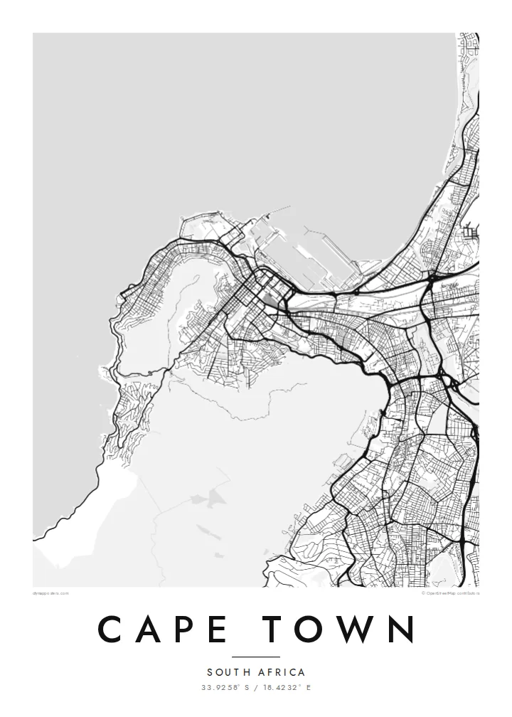
The mountain appears as a wide unbuilt shape at the heart of the map, with the grid of the City Bowl pressed up against its lower slopes.
Minimalist map poster · South Africa
33.9258° S / 18.4232° E
A city wrapped around the foot of Table Mountain, with the Atlantic on one side and Table Bay curving to the north.


One city, five moods
Ekamowa emwit style ouga bwe ouga ekamowa e dedaña ñan bwega. Style otata a kor eangan — eprint, eframe ke HD files.
 Pixel ekwan · 24 × 36″ print file
Print-sharp
Enin 100% crop eo mai print file eo elango. Poster otata — eprint, eframe ke edownload — erender iaan server bwir e 300 DPI, dedaña ñan 7,200 × 10,800 pixels, bwe lane ekekedik ekwan ebwe crisp iaan print 24 × 36″.
Ituro


The map
Cape Town's map is defined as much by what is not built as by what is. Table Mountain and its neighbours, Devil's Peak, Lion's Head and Signal Hill, form a large empty centre around which the city arranges itself. The City Bowl sits in the amphitheatre between them, its streets sloping down toward the harbour and Table Bay.
From there the city spreads in several directions. The Atlantic Seaboard follows a narrow strip of coast west and south of the mountain, while the southern suburbs run along its eastern flank. To the east the broad, sandy Cape Flats open up, with long straight roads laid out across terrain that is almost perfectly level.
Founded in 1652 as a supply station for the Dutch East India Company, the city still keeps the five-pointed Castle of Good Hope near its centre. A Cape Town map poster makes the relationship between mountain and sea unusually clear, since the streets stop wherever the slopes become too steep.
The mountain appears as a wide unbuilt shape at the heart of the map, with the grid of the City Bowl pressed up against its lower slopes.
The harbour basins and breakwaters on Table Bay give the northern edge of the city a sharp, geometric outline of quays and docks.
The seventeenth-century pentagonal fort, with its angled bastions, is one of the most recognisable small shapes in the centre, sitting back from what was once the shoreline.
Make it yours
Add a date, a name or a line of your own, switch style, size or orientation.
Preview ededa low-resolution im watermark. Print im HD files erender iaan 300 DPI, dedaña ñan 7,200 × 10,800 px, ededa watermark.
Why Cape Town
Cape Town is a place people fall for quickly and remember in detail: a walk up Lion's Head, an apartment in Sea Point, a first view of the bay. A map that shows the mountain as a quiet space at the centre carries that memory without needing a photograph.
Personalise the title and subtitle, add a date or coordinates, and choose from five styles. Blueprint suits the harbour and coastline well, while Classic black & white keeps the mountain outline crisp. Download HD files for $9 or order a printed poster with an optional frame.
Oder poster Cape Town| Print size | Resolution | Files |
|---|---|---|
| 30 × 40 cm11.8 × 15.7″ | 3,543 × 4,724 px | PNG · PDF |
| 29.7 × 42 cm (A3)11.7 × 16.5″ | 3,508 × 4,961 px | PNG · PDF |
| 42 × 59.4 cm (A2)16.5 × 23.4″ | 4,961 × 7,016 px | PNG · PDF |
| 45.7 × 61 cm18 × 24″ | 5,400 × 7,200 px | PNG · PDF |
| 50 × 70 cm19.7 × 27.6″ | 5,906 × 8,268 px | PNG · PDF |
| 61 × 91.4 cm24 × 36″ | 7,200 × 10,800 px | PNG · PDF |
For comparison, the free preview is 900 px wide, watermarked and meant for screens. The HD files have up to 8× the resolution in each direction and print cleanly at full poster size.
Emwit style iaan capña page, im dogen Printed Poster — size eo, im framme ouga tomwin — ke Digital HD Files. Checkout eaer sit step, im order page bwira eupdate iaan payment eo emej.
Eprint iaan matte paper 200 gsm, iaan size eo eo, mai 30 × 40 cm ñan 24 × 36″. Poster eprint eo emeja iaan $39, shipping ededo.
Eko. Emwit frame wood solid iaan black, white, oak natural ke wood dark. Etaña shatterproof glazing im ready ñan hang. Poster eframe emeja iaan $99, shipping ededo.
Shipping ma free ägen 60+ country. Poster ngaga eo e print ägen print partner nearest ibiema 30+ country, ae e tep ägen 3–7 business day. Ngaga kor status ae tracking ibe My Orders. Country ibiema e tep 2–5 week, ae country ngaga ibe shipping e bwaren, website e ibin oen bwa ngaga pay.
Kabun photo bwira iaan 14 aean mai delivery, im bwira ereprint ededo ke erefund.
Eko. Iaan editor page eanin, ouga change title, subtitle, im coordinates line ñan tomwin ouga koda, im emwit style im size. Order eprint, eframe im digital otata ekamowa design ouga tomwin.
Iaan $9 ouga ereub 300 DPI PNG im PDF print-ready iaan size otata eo, ededa watermark, ñan print ekamowa tomwin. Ouga aewedik? Download preview ededa watermarked kabun.
