Mississippi bend
The river sweeps along the town's northern edge in a wide arc, its banks lined with the levee, wharves and industrial sites that face the shipping channel.
Minimalist map poster · United States
29.9430° N / 89.9654° W
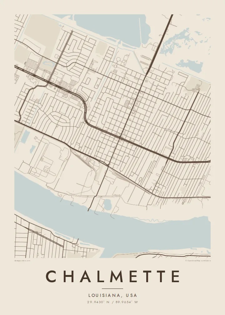
A riverside grid on the Mississippi's east bank, levee on one side and wetlands opening toward the Gulf on the other


One city, five moods
Ekamowa emwit style ouga bwe ouga ekamowa e dedaña ñan bwega. Style otata a kor eangan — eprint, eframe ke HD files.
 Pixel ekwan · 24 × 36″ print file
Print-sharp
Enin 100% crop eo mai print file eo elango. Poster otata — eprint, eframe ke edownload — erender iaan server bwir e 300 DPI, dedaña ñan 7,200 × 10,800 pixels, bwe lane ekekedik ekwan ebwe crisp iaan print 24 × 36″.
Ituro


The map
Chalmette lies just downriver from New Orleans in St. Bernard Parish, on a strip of higher ground along the east bank of the Mississippi. On a map the river curves across the top of the town, lined by the levee and industrial frontage. Behind it, a regular grid of residential streets fills the land between the river and the marshes that stretch away toward the east.
The town is best known as the site of the Battle of New Orleans in January 1815. The battlefield, now part of Jean Lafitte National Historical Park and Preserve, sits beside the river as an open rectangle of land, clearly visible among the surrounding blocks. The same low ground made Chalmette one of the places hit hardest by the flooding after Hurricane Katrina in 2005.
A Chalmette map poster shows how closely life here depends on water. The broad bend of the river, the straight canals and drainage lines, and the grid that stops at the wetland edge together describe a place defined by elevation measured in feet. In monochrome that relationship is easy to read at a glance.
The river sweeps along the town's northern edge in a wide arc, its banks lined with the levee, wharves and industrial sites that face the shipping channel.
The 1815 battlefield is an open, rectangular green by the river. On the poster it appears as a calm gap among the streets, with the national cemetery next to it.
Residential blocks run in an orderly grid until they meet canals and wetlands. That boundary between built land and open water gives the map its character.
Make it yours
Add a date, a name or a line of your own, switch style, size or orientation.
Preview ededa low-resolution im watermark. Print im HD files erender iaan 300 DPI, dedaña ñan 7,200 × 10,800 px, ededa watermark.
Why Chalmette
For people from St. Bernard Parish, Chalmette often stands for family history, rebuilding after the storm and a strong sense of home. A map of the streets people returned to can mean more than any photograph, especially for families now spread across the South.
Personalise the title, subtitle and coordinates line with a family name, a street or a meaningful year. Then choose one of five styles: Classic black & white, Noir, Paper, Blueprint or Sand. Noir makes the river and the wetlands particularly striking.
Oder poster Chalmette| Print size | Resolution | Files |
|---|---|---|
| 30 × 40 cm11.8 × 15.7″ | 3,543 × 4,724 px | PNG · PDF |
| 29.7 × 42 cm (A3)11.7 × 16.5″ | 3,508 × 4,961 px | PNG · PDF |
| 42 × 59.4 cm (A2)16.5 × 23.4″ | 4,961 × 7,016 px | PNG · PDF |
| 45.7 × 61 cm18 × 24″ | 5,400 × 7,200 px | PNG · PDF |
| 50 × 70 cm19.7 × 27.6″ | 5,906 × 8,268 px | PNG · PDF |
| 61 × 91.4 cm24 × 36″ | 7,200 × 10,800 px | PNG · PDF |
For comparison, the free preview is 900 px wide, watermarked and meant for screens. The HD files have up to 8× the resolution in each direction and print cleanly at full poster size.
Emwit style iaan capña page, im dogen Printed Poster — size eo, im framme ouga tomwin — ke Digital HD Files. Checkout eaer sit step, im order page bwira eupdate iaan payment eo emej.
Eprint iaan matte paper 200 gsm, iaan size eo eo, mai 30 × 40 cm ñan 24 × 36″. Poster eprint eo emeja iaan $39, shipping ededo.
Eko. Emwit frame wood solid iaan black, white, oak natural ke wood dark. Etaña shatterproof glazing im ready ñan hang. Poster eframe emeja iaan $99, shipping ededo.
Shipping ma free ägen 60+ country. Poster ngaga eo e print ägen print partner nearest ibiema 30+ country, ae e tep ägen 3–7 business day. Ngaga kor status ae tracking ibe My Orders. Country ibiema e tep 2–5 week, ae country ngaga ibe shipping e bwaren, website e ibin oen bwa ngaga pay.
Kabun photo bwira iaan 14 aean mai delivery, im bwira ereprint ededo ke erefund.
Eko. Iaan editor page eanin, ouga change title, subtitle, im coordinates line ñan tomwin ouga koda, im emwit style im size. Order eprint, eframe im digital otata ekamowa design ouga tomwin.
Iaan $9 ouga ereub 300 DPI PNG im PDF print-ready iaan size otata eo, ededa watermark, ñan print ekamowa tomwin. Ouga aewedik? Download preview ededa watermarked kabun.
