Railway and main road
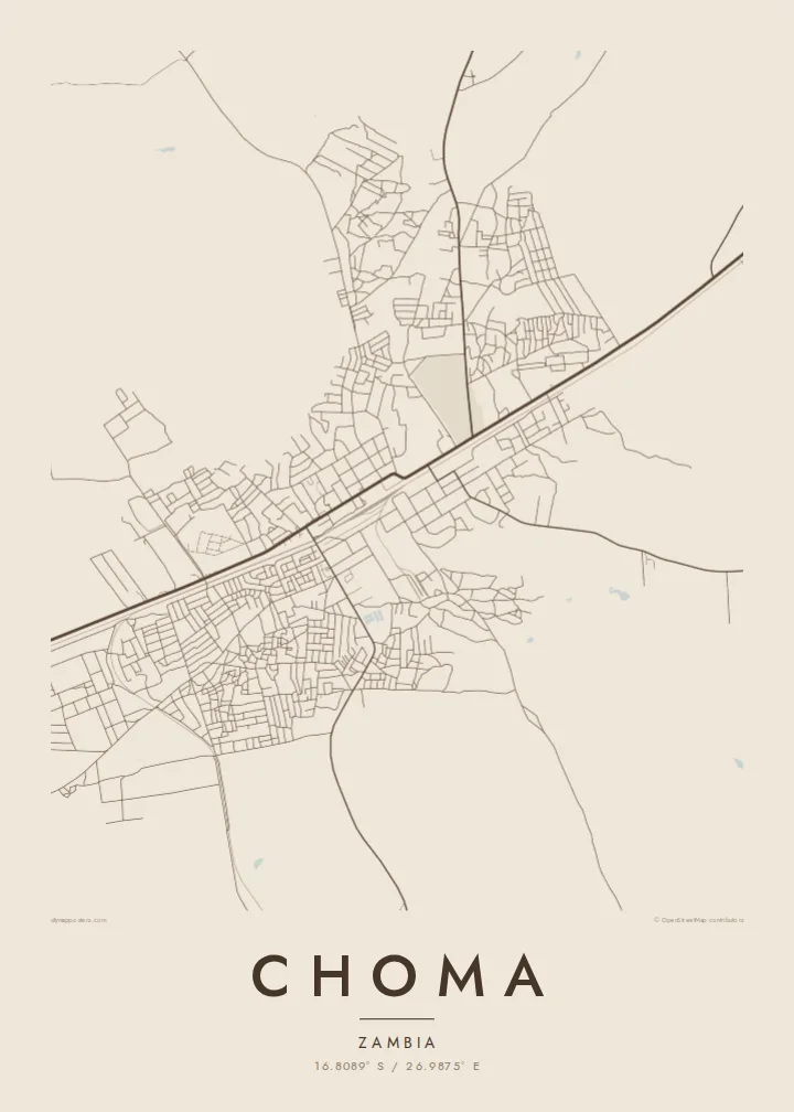
Both the railway line and the main road between Lusaka and Livingstone pass through Choma. They run side by side across the map and form the town's backbone.
Minimalist map poster · Zambia
16.8089° S / 26.9875° E
A provincial capital on the Zambian plateau, laid out along the railway and main road between Lusaka and Livingstone.


One city, five moods
Ekamowa emwit style ouga bwe ouga ekamowa e dedaña ñan bwega. Style otata a kor eangan — eprint, eframe ke HD files.
 Pixel ekwan · 24 × 36″ print file
Print-sharp
Enin 100% crop eo mai print file eo elango. Poster otata — eprint, eframe ke edownload — erender iaan server bwir e 300 DPI, dedaña ñan 7,200 × 10,800 pixels, bwe lane ekekedik ekwan ebwe crisp iaan print 24 × 36″.
Ituro


The map
Choma is the capital of Zambia's Southern Province. It sits on the high plateau between Lusaka and Livingstone. Its layout follows the main transport lines: the railway and the main road run through it, and the town grew along both. From above, the centre is a small grid of commercial streets, surrounded by residential areas that spread out into open savanna.
The land around Choma is mostly farmland, and the town serves as a trading and administrative centre for the surrounding area. Beyond the centre, the street network becomes sparser. Planned residential areas give way to informal paths, and fields and scattered homesteads take over. The town has a local museum that focuses on the region's culture.
A Choma map poster reflects this simple plan: a railway and a road, a compact grid between them and neighbourhoods that thin out towards the countryside. It suits people from Southern Province or anyone who has travelled the road south to Victoria Falls and remembers the stop in Choma along the way.
Both the railway line and the main road between Lusaka and Livingstone pass through Choma. They run side by side across the map and form the town's backbone.
Commercial streets are grouped in a small grid near the transport lines. This is the densest part of the map, where shops, offices and markets are concentrated.
Towards the outskirts, planned streets give way to informal paths and open land. The map fades out gradually into the surrounding savanna and farmland.
Make it yours
Add a date, a name or a line of your own, switch style, size or orientation.
Preview ededa low-resolution im watermark. Print im HD files erender iaan 300 DPI, dedaña ñan 7,200 × 10,800 px, ededa watermark.
Why Choma
A map of Choma is a personal choice. It might be where someone went to school or where their family has farmed for generations, or a place remembered from a trip south through Zambia. The simple layout makes a calm, orderly poster.
You can change the title, subtitle and coordinates line to add a name, a family, a year or a short note. There are five styles: Classic black & white, Noir, Paper, Blueprint and Sand.
Oder poster Choma| Print size | Resolution | Files |
|---|---|---|
| 30 × 40 cm11.8 × 15.7″ | 3,543 × 4,724 px | PNG · PDF |
| 29.7 × 42 cm (A3)11.7 × 16.5″ | 3,508 × 4,961 px | PNG · PDF |
| 42 × 59.4 cm (A2)16.5 × 23.4″ | 4,961 × 7,016 px | PNG · PDF |
| 45.7 × 61 cm18 × 24″ | 5,400 × 7,200 px | PNG · PDF |
| 50 × 70 cm19.7 × 27.6″ | 5,906 × 8,268 px | PNG · PDF |
| 61 × 91.4 cm24 × 36″ | 7,200 × 10,800 px | PNG · PDF |
For comparison, the free preview is 900 px wide, watermarked and meant for screens. The HD files have up to 8× the resolution in each direction and print cleanly at full poster size.
Emwit style iaan capña page, im dogen Printed Poster — size eo, im framme ouga tomwin — ke Digital HD Files. Checkout eaer sit step, im order page bwira eupdate iaan payment eo emej.
Eprint iaan matte paper 200 gsm, iaan size eo eo, mai 30 × 40 cm ñan 24 × 36″. Poster eprint eo emeja iaan $39, shipping ededo.
Eko. Emwit frame wood solid iaan black, white, oak natural ke wood dark. Etaña shatterproof glazing im ready ñan hang. Poster eframe emeja iaan $99, shipping ededo.
Shipping ma free ägen 60+ country. Poster ngaga eo e print ägen print partner nearest ibiema 30+ country, ae e tep ägen 3–7 business day. Ngaga kor status ae tracking ibe My Orders. Country ibiema e tep 2–5 week, ae country ngaga ibe shipping e bwaren, website e ibin oen bwa ngaga pay.
Kabun photo bwira iaan 14 aean mai delivery, im bwira ereprint ededo ke erefund.
Eko. Iaan editor page eanin, ouga change title, subtitle, im coordinates line ñan tomwin ouga koda, im emwit style im size. Order eprint, eframe im digital otata ekamowa design ouga tomwin.
Iaan $9 ouga ereub 300 DPI PNG im PDF print-ready iaan size otata eo, ededa watermark, ñan print ekamowa tomwin. Ouga aewedik? Download preview ededa watermarked kabun.
