Ginza grid
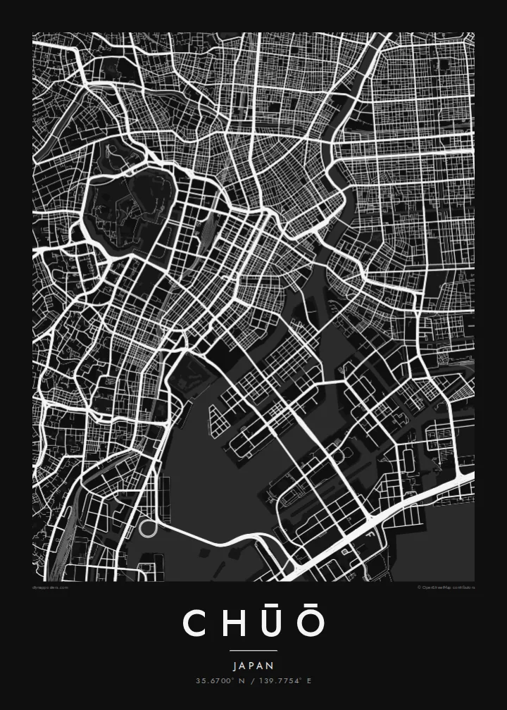
Ginza's regular blocks and main avenues form one of the most orderly street patterns in Tokyo. On the map it sits between former canal routes.
Minimalist map poster · Japan
35.6700° N / 139.7754° E
Tokyo's historic commercial heart between the Imperial moats and the Sumida, extending onto reclaimed islands in the bay



One city, five moods
Ekamowa emwit style ouga bwe ouga ekamowa e dedaña ñan bwega. Style otata a kor eangan — eprint, eframe ke HD files.
 Pixel ekwan · 24 × 36″ print file
Print-sharp
Enin 100% crop eo mai print file eo elango. Poster otata — eprint, eframe ke edownload — erender iaan server bwir e 300 DPI, dedaña ñan 7,200 × 10,800 pixels, bwe lane ekekedik ekwan ebwe crisp iaan print 24 × 36″.
Ituro


The map
Chūō is one of Tokyo's central wards, lying between the area around the Imperial Palace and Tokyo Bay. It includes Nihonbashi, the old merchant district, and Ginza, famous for department stores and shopping. In the Edo period, the Nihonbashi bridge was the starting point of the main roads out of the city, and road distances in Japan are still measured from a marker there.
The ward's map is shaped by water. The Sumida River runs along its eastern side, and canals and old moats once surrounded the commercial districts. Some of these are now covered by expressways. To the southeast, the islands of Tsukishima, Kachidoki and Harumi were built on reclaimed land in the bay and are now filled with apartment towers.
A Chūō map poster shows the tight grid of Ginza and Nihonbashi, the wide Sumida, and the geometric outlines of the reclaimed islands. Few parts of Tokyo show so clearly how the city has grown out into the water. It makes a precise and detailed print for anyone who has worked, shopped or lived in the centre of Tokyo.
Ginza's regular blocks and main avenues form one of the most orderly street patterns in Tokyo. On the map it sits between former canal routes.
The old merchant district around the famous bridge, which served as the Edo-period starting point for the main roads leading out of the city.
Tsukishima, Kachidoki and Harumi extend into Tokyo Bay as angular blocks of reclaimed land, connected to the rest of the city by long bridges.
Make it yours
Add a date, a name or a line of your own, switch style, size or orientation.
Preview ededa low-resolution im watermark. Print im HD files erender iaan 300 DPI, dedaña ñan 7,200 × 10,800 px, ededa watermark.
Why Chūō
For many people, Chūō is the part of Tokyo where they worked, stayed or walked on their first visit. The map puts Ginza, Nihonbashi and the Sumida together in one clear view.
You can personalise the title, subtitle and coordinates, for example with an office address or the year of a trip. Choose one of five styles: Classic black & white, Noir, Paper, Blueprint or Sand. Noir suits the dense grid especially well.
Oder poster Chūō| Print size | Resolution | Files |
|---|---|---|
| 30 × 40 cm (11.8 × 15.7″) | 3,543 × 4,724 px | PNG · PDF |
| 29.7 × 42 cm (A3, 11.7 × 16.5″) | 3,508 × 4,961 px | PNG · PDF |
| 42 × 59.4 cm (A2, 16.5 × 23.4″) | 4,961 × 7,016 px | PNG · PDF |
| 45.7 × 61 cm (18 × 24″) | 5,400 × 7,200 px | PNG · PDF |
| 50 × 70 cm (19.7 × 27.6″) | 5,906 × 8,268 px | PNG · PDF |
| 61 × 91.4 cm (24 × 36″) | 7,200 × 10,800 px | PNG · PDF |
For comparison, the free preview is 900 px wide, watermarked and meant for screens. The HD files have up to 8× the resolution in each direction and print cleanly at full poster size.
Emwit style iaan capña page, im dogen Printed Poster — size eo, im framme ouga tomwin — ke Digital HD Files. Checkout eaer sit step, im order page bwira eupdate iaan payment eo emej.
Eprint iaan matte paper 200 gsm, iaan size eo eo, mai 30 × 40 cm ñan 24 × 36″. Poster eprint eo emeja iaan $39, shipping ededo.
Eko. Emwit frame wood solid iaan black, white, oak natural ke wood dark. Etaña shatterproof glazing im ready ñan hang. Poster eframe emeja iaan $99, shipping ededo.
Eaeoen e ngaaba ngeni ouwa age ngaabe. Ngaeo poster e ibiyaneo ibon e print partner eg ibom ngaen ingi ngae 30+ eben, e naeo e yan ngaae e 3–7 aon wan ewa. Kom ngaa e eain ingi tracking ibon My Orders. Tauweo ebe 2–5 wik, ingi ibon ngaen ibun e ngaeo ngaeigie, e saet e sooe nuwe kom e pae.
Kabun photo bwira iaan 14 aean mai delivery, im bwira ereprint ededo ke erefund.
Eko. Iaan editor page eanin, ouga change title, subtitle, im coordinates line ñan tomwin ouga koda, im emwit style im size. Order eprint, eframe im digital otata ekamowa design ouga tomwin.
Iaan $9 ouga ereub 300 DPI PNG im PDF print-ready iaan size otata eo, ededa watermark, ñan print ekamowa tomwin. Ouga aewedik? Download preview ededa watermarked kabun.
