Rebuilt grid centre
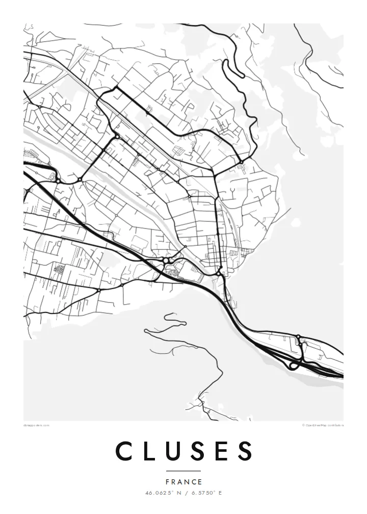
After the 1844 fire, the centre was laid out again as a regular grid. Its straight streets and right angles stand out clearly against the curves of the surrounding valley.
Minimalist map poster · France
46.0625° N / 6.5750° E
A grid-planned watchmaking town squeezed into the Arve valley between steep Alpine slopes


One city, five moods
Ekamowa emwit style ouga bwe ouga ekamowa e dedaña ñan bwega. Style otata a kor eangan — eprint, eframe ke HD files.
 Pixel ekwan · 24 × 36″ print file
Print-sharp
Enin 100% crop eo mai print file eo elango. Poster otata — eprint, eframe ke edownload — erender iaan server bwir e 300 DPI, dedaña ñan 7,200 × 10,800 pixels, bwe lane ekekedik ekwan ebwe crisp iaan print 24 × 36″.
Ituro


The map
Cluses lies in the Arve valley in Haute-Savoie, at a point where the mountains close in and the valley narrows, which is where the town's name comes from. From above, the town fills the flat valley floor between the river and the slopes. Steep forested mountainsides rise on both sides, and the motorway and railway run parallel to the Arve through the gap.
The centre has an unusually regular layout for an Alpine town. After a fire destroyed much of Cluses in 1844, it was rebuilt on a planned grid of straight streets, and that pattern is still clear on the map. Cluses is closely linked to precision work: its watchmaking school dates back to the nineteenth century, and the valley later became a centre of décolletage, the machining of small precision parts.
A Cluses map poster shows how a planned town fits into a mountain landscape. The rectangular blocks of the centre sit beside the curving river and the long transport lines threading through the valley. The mountains themselves appear as empty space pressing in from each side. For people who work in the valley's workshops or pass through on the way to the ski resorts, it is a precise and recognisable image.
After the 1844 fire, the centre was laid out again as a regular grid. Its straight streets and right angles stand out clearly against the curves of the surrounding valley.
The river, the motorway and the railway run side by side through the narrow valley, three parallel lines that organise the whole map.
Steep slopes close in on both sides of town. On the poster they read as blank space that frames the dense valley floor.
Make it yours
Add a date, a name or a line of your own, switch style, size or orientation.
Preview ededa low-resolution im watermark. Print im HD files erender iaan 300 DPI, dedaña ñan 7,200 × 10,800 px, ededa watermark.
Why Cluses
Cluses is a town of skilled work and mountain views, and its map has a precision that suits it. It makes a good gift for someone from the watchmaking or décolletage trades, or anyone who has settled at the foot of the Alps.
Add a title, a subtitle with a name or date, and keep or change the coordinates. Pick Classic black & white, Noir, Paper, Blueprint or Sand. Blueprint suits the technical tradition, and Paper gives a softer, more domestic tone.
Oder poster Cluses| Print size | Resolution | Files |
|---|---|---|
| 30 × 40 cm11.8 × 15.7″ | 3,543 × 4,724 px | PNG · PDF |
| 29.7 × 42 cm (A3)11.7 × 16.5″ | 3,508 × 4,961 px | PNG · PDF |
| 42 × 59.4 cm (A2)16.5 × 23.4″ | 4,961 × 7,016 px | PNG · PDF |
| 45.7 × 61 cm18 × 24″ | 5,400 × 7,200 px | PNG · PDF |
| 50 × 70 cm19.7 × 27.6″ | 5,906 × 8,268 px | PNG · PDF |
| 61 × 91.4 cm24 × 36″ | 7,200 × 10,800 px | PNG · PDF |
For comparison, the free preview is 900 px wide, watermarked and meant for screens. The HD files have up to 8× the resolution in each direction and print cleanly at full poster size.
Emwit style iaan capña page, im dogen Printed Poster — size eo, im framme ouga tomwin — ke Digital HD Files. Checkout eaer sit step, im order page bwira eupdate iaan payment eo emej.
Eprint iaan matte paper 200 gsm, iaan size eo eo, mai 30 × 40 cm ñan 24 × 36″. Poster eprint eo emeja iaan $39, shipping ededo.
Eko. Emwit frame wood solid iaan black, white, oak natural ke wood dark. Etaña shatterproof glazing im ready ñan hang. Poster eframe emeja iaan $99, shipping ededo.
Shipping ma free ägen 60+ country. Poster ngaga eo e print ägen print partner nearest ibiema 30+ country, ae e tep ägen 3–7 business day. Ngaga kor status ae tracking ibe My Orders. Country ibiema e tep 2–5 week, ae country ngaga ibe shipping e bwaren, website e ibin oen bwa ngaga pay.
Kabun photo bwira iaan 14 aean mai delivery, im bwira ereprint ededo ke erefund.
Eko. Iaan editor page eanin, ouga change title, subtitle, im coordinates line ñan tomwin ouga koda, im emwit style im size. Order eprint, eframe im digital otata ekamowa design ouga tomwin.
Iaan $9 ouga ereub 300 DPI PNG im PDF print-ready iaan size otata eo, ededa watermark, ñan print ekamowa tomwin. Ouga aewedik? Download preview ededa watermarked kabun.
