River frontier
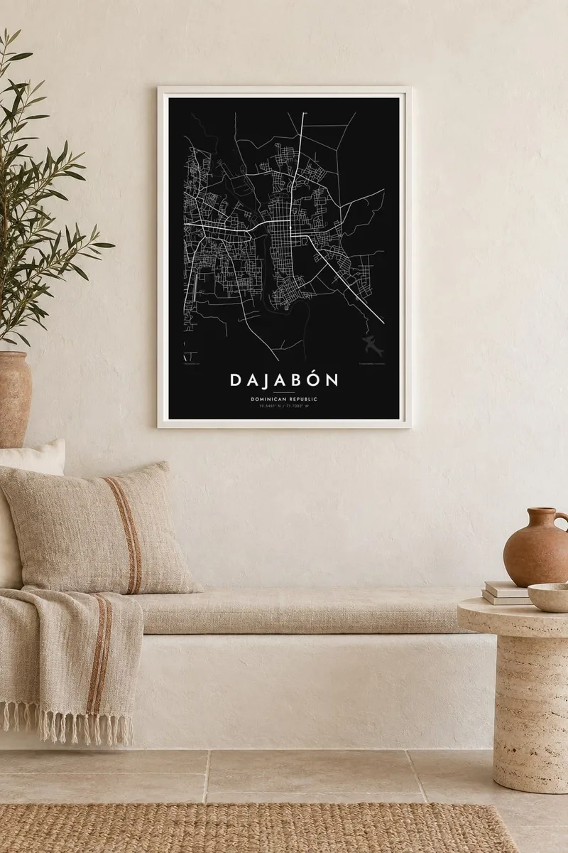
The border river runs along the western side of town. On the map it separates two street networks, one Dominican and one Haitian, drawn with the same line.
Minimalist map poster · Dominican Republic
19.5481° N / 71.7082° W
A border town facing Haiti across a narrow river, its grid of streets running right up to the international bridge.


One city, five moods
Ekamowa emwit style ouga bwe ouga ekamowa e dedaña ñan bwega. Style otata a kor eangan — eprint, eframe ke HD files.
 Pixel ekwan · 24 × 36″ print file
Print-sharp
Enin 100% crop eo mai print file eo elango. Poster otata — eprint, eframe ke edownload — erender iaan server bwir e 300 DPI, dedaña ñan 7,200 × 10,800 pixels, bwe lane ekekedik ekwan ebwe crisp iaan print 24 × 36″.
Ituro


The map
Dajabón is the capital of Dajabón Province in the northwestern Dominican Republic, right on the border with Haiti. The river that forms the frontier here, known on the Dominican side as the Masacre, runs along the western edge of the town. The Haitian city of Ouanaminthe sits on the opposite bank. A bridge links the two, and the street pattern leads toward it.
The town follows a straightforward grid of rectangular blocks around a central square, typical of Dominican provincial towns. Beyond its edges the land is flat and mostly agricultural. Roads lead east toward Santiago and the Cibao valley and north toward the coast at Monte Cristi. From above, it is a small, orderly settlement at the western end of the country.
Dajabón is widely known for its binational market, held twice a week, when traders and buyers cross the bridge in large numbers and the streets near the border fill with stalls. A Dajabón map poster shows the setting that makes this possible: two towns, one river and a single crossing between them.
The border river runs along the western side of town. On the map it separates two street networks, one Dominican and one Haitian, drawn with the same line.
A single crossing connects Dajabón to Ouanaminthe, and the town's main streets converge toward it, giving the composition a clear focal point.
Straight streets and regular blocks around a central plaza make up the town centre, a tidy pattern that contrasts with the river's irregular course.
Make it yours
Add a date, a name or a line of your own, switch style, size or orientation.
Preview ededa low-resolution im watermark. Print im HD files erender iaan 300 DPI, dedaña ñan 7,200 × 10,800 px, ededa watermark.
Why Dajabón
For people from Dajabón, or anyone who has worked and traded on both sides of the frontier, this map describes a very specific place: where one country ends and another begins. It is a quietly meaningful image, more about connection than division.
Change the title, subtitle and coordinates line to mark a name or date, and choose Classic black & white, Noir, Paper, Blueprint or Sand. The $9 digital HD download includes six sizes as PNG and PDF, and printed matte posters ship from partners in more than 30 countries.
Oder poster Dajabón| Print size | Resolution | Files |
|---|---|---|
| 30 × 40 cm11.8 × 15.7″ | 3,543 × 4,724 px | PNG · PDF |
| 29.7 × 42 cm (A3)11.7 × 16.5″ | 3,508 × 4,961 px | PNG · PDF |
| 42 × 59.4 cm (A2)16.5 × 23.4″ | 4,961 × 7,016 px | PNG · PDF |
| 45.7 × 61 cm18 × 24″ | 5,400 × 7,200 px | PNG · PDF |
| 50 × 70 cm19.7 × 27.6″ | 5,906 × 8,268 px | PNG · PDF |
| 61 × 91.4 cm24 × 36″ | 7,200 × 10,800 px | PNG · PDF |
For comparison, the free preview is 900 px wide, watermarked and meant for screens. The HD files have up to 8× the resolution in each direction and print cleanly at full poster size.
Emwit style iaan capña page, im dogen Printed Poster — size eo, im framme ouga tomwin — ke Digital HD Files. Checkout eaer sit step, im order page bwira eupdate iaan payment eo emej.
Eprint iaan matte paper 200 gsm, iaan size eo eo, mai 30 × 40 cm ñan 24 × 36″. Poster eprint eo emeja iaan $39, shipping ededo.
Eko. Emwit frame wood solid iaan black, white, oak natural ke wood dark. Etaña shatterproof glazing im ready ñan hang. Poster eframe emeja iaan $99, shipping ededo.
Shipping ma free ägen 60+ country. Poster ngaga eo e print ägen print partner nearest ibiema 30+ country, ae e tep ägen 3–7 business day. Ngaga kor status ae tracking ibe My Orders. Country ibiema e tep 2–5 week, ae country ngaga ibe shipping e bwaren, website e ibin oen bwa ngaga pay.
Kabun photo bwira iaan 14 aean mai delivery, im bwira ereprint ededo ke erefund.
Eko. Iaan editor page eanin, ouga change title, subtitle, im coordinates line ñan tomwin ouga koda, im emwit style im size. Order eprint, eframe im digital otata ekamowa design ouga tomwin.
Iaan $9 ouga ereub 300 DPI PNG im PDF print-ready iaan size otata eo, ededa watermark, ñan print ekamowa tomwin. Ouga aewedik? Download preview ededa watermarked kabun.
