Boyne Viaduct
Opened in 1855, the railway viaduct spans the Boyne east of the centre, its long straight line crossing the river and the quays below it in a single stroke on the map.
Minimalist map poster · Ireland
53.7189° N / 6.3478° W
An old port town on both banks of the Boyne, crossed by a tall railway viaduct near the river's mouth.




One city, five moods
Ekamowa emwit style ouga bwe ouga ekamowa e dedaña ñan bwega. Style otata a kor eangan — eprint, eframe ke HD files.
 Pixel ekwan · 24 × 36″ print file
Print-sharp
Enin 100% crop eo mai print file eo elango. Poster otata — eprint, eframe ke edownload — erender iaan server bwir e 300 DPI, dedaña ñan 7,200 × 10,800 pixels, bwe lane ekekedik ekwan ebwe crisp iaan print 24 × 36″.
Ituro


The map
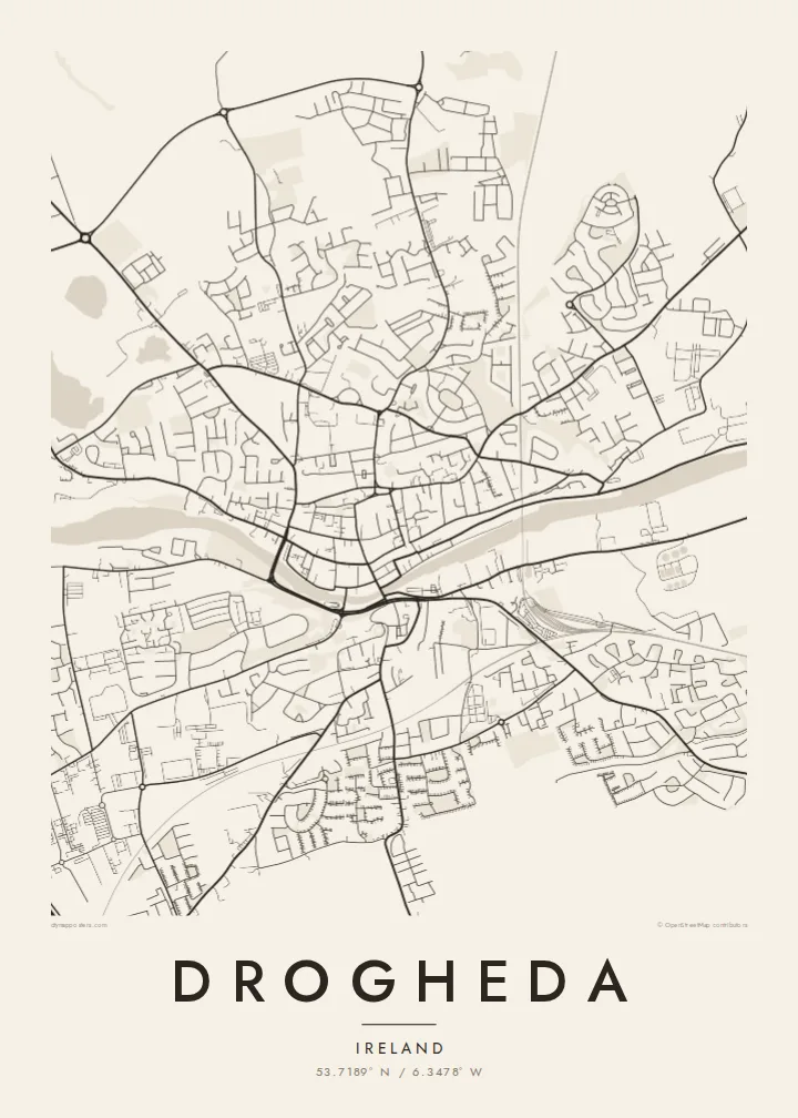
Drogheda stands on the River Boyne a few kilometres upstream from its mouth on the Irish Sea, and the town has grown on both banks, straddling the boundary between counties Louth and Meath. From above, the river cuts a clear line through the centre, with the medieval street pattern gathered along the north bank and the land rising on the south side toward Millmount.
Millmount, a prominent mound topped by a Martello tower, overlooks the town, and parts of the medieval walls survive, most notably St Laurence's Gate, a tall barbican on the eastern side of the old centre. The town was besieged by Oliver Cromwell in 1649, and St Peter's Church holds the preserved head of St Oliver Plunkett.
East of the centre, the Boyne Viaduct carries the Dublin–Belfast railway high above the river, one of the most striking structures on the Irish rail network. Upriver lie Brú na Bóinne and the site of the Battle of the Boyne. A Drogheda map poster frames the river, the viaduct and the old town in a single composition.
Opened in 1855, the railway viaduct spans the Boyne east of the centre, its long straight line crossing the river and the quays below it in a single stroke on the map.
North of the river, the old town keeps a compact pattern of narrow streets and lanes, with St Laurence's Gate marking the line of the former walls.
On the south bank, the mound of Millmount rises above the town with its Martello tower, the high point from which the whole river crossing can be seen.
Make it yours
Add a date, a name or a line of your own, switch style, size or orientation.
Preview ededa low-resolution im watermark. Print im HD files erender iaan 300 DPI, dedaña ñan 7,200 × 10,800 px, ededa watermark.
Why Drogheda
Drogheda is a hometown for many who have moved to Dublin or further afield, and a gateway to the Boyne Valley for visitors. A map of its river, viaduct and old streets is a clear, understated way to keep the town close.
Add a family name or a date to the title and subtitle, adjust the coordinates line, and choose from five styles, including Noir and Blueprint. HD files cost $9 in six sizes, and printed posters ship from partners in more than 30 countries.
Oder poster Drogheda| Print size | Resolution | Files |
|---|---|---|
| 30 × 40 cm11.8 × 15.7″ | 3,543 × 4,724 px | PNG · PDF |
| 29.7 × 42 cm (A3)11.7 × 16.5″ | 3,508 × 4,961 px | PNG · PDF |
| 42 × 59.4 cm (A2)16.5 × 23.4″ | 4,961 × 7,016 px | PNG · PDF |
| 45.7 × 61 cm18 × 24″ | 5,400 × 7,200 px | PNG · PDF |
| 50 × 70 cm19.7 × 27.6″ | 5,906 × 8,268 px | PNG · PDF |
| 61 × 91.4 cm24 × 36″ | 7,200 × 10,800 px | PNG · PDF |
For comparison, the free preview is 900 px wide, watermarked and meant for screens. The HD files have up to 8× the resolution in each direction and print cleanly at full poster size.
Emwit style iaan capña page, im dogen Printed Poster — size eo, im framme ouga tomwin — ke Digital HD Files. Checkout eaer sit step, im order page bwira eupdate iaan payment eo emej.
Eprint iaan matte paper 200 gsm, iaan size eo eo, mai 30 × 40 cm ñan 24 × 36″. Poster eprint eo emeja iaan $39, shipping ededo.
Eko. Emwit frame wood solid iaan black, white, oak natural ke wood dark. Etaña shatterproof glazing im ready ñan hang. Poster eframe emeja iaan $99, shipping ededo.
Shipping ma free ägen 60+ country. Poster ngaga eo e print ägen print partner nearest ibiema 30+ country, ae e tep ägen 3–7 business day. Ngaga kor status ae tracking ibe My Orders. Country ibiema e tep 2–5 week, ae country ngaga ibe shipping e bwaren, website e ibin oen bwa ngaga pay.
Kabun photo bwira iaan 14 aean mai delivery, im bwira ereprint ededo ke erefund.
Eko. Iaan editor page eanin, ouga change title, subtitle, im coordinates line ñan tomwin ouga koda, im emwit style im size. Order eprint, eframe im digital otata ekamowa design ouga tomwin.
Iaan $9 ouga ereub 300 DPI PNG im PDF print-ready iaan size otata eo, ededa watermark, ñan print ekamowa tomwin. Ouga aewedik? Download preview ededa watermarked kabun.
