Gate streets cross
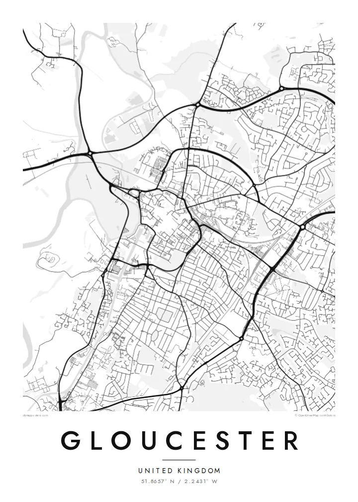
Northgate, Southgate, Eastgate and Westgate meet at the Cross in the city centre, a street plan inherited from Roman Glevum and still perfectly legible.
Minimalist map poster · United Kingdom
51.8657° N / 2.2431° W
A cathedral city on the Severn, its Roman cross of four gate streets meeting at the centre beside inland docks.
One city, five moods
Ekamowa emwit style ouga bwe ouga ekamowa e dedaña ñan bwega. Style otata a kor eangan — eprint, eframe ke HD files.
 Pixel ekwan · 24 × 36″ print file
Print-sharp
Enin 100% crop eo mai print file eo elango. Poster otata — eprint, eframe ke edownload — erender iaan server bwir e 300 DPI, dedaña ñan 7,200 × 10,800 pixels, bwe lane ekekedik ekwan ebwe crisp iaan print 24 × 36″.
Ituro


The map
Gloucester stands on the east bank of the River Severn, for centuries its lowest crossing point. The Romans founded Glevum here, and the city centre still follows their layout: four main streets, Northgate, Southgate, Eastgate and Westgate, meet at a central junction known as the Cross. Beyond this core, suburbs spread across the flat Severn vale toward the edge of the Cotswolds.
Gloucester Cathedral, with its great Perpendicular tower and fan-vaulted cloisters, rises just north-west of the Cross; its cloisters have appeared in the Harry Potter films. To the south-west lie Gloucester Docks, Britain's most inland port, connected to the Severn estuary by the Gloucester and Sharpness Canal and lined with restored Victorian warehouses.
A Gloucester map poster makes the Roman plan easy to read. The four gate streets form a clear cross, the docks appear as rectangular basins beside the river, and the canal heads away in a long straight line. The Severn itself splits into two channels around Alney Island, adding a loose, natural shape to the western side.
Northgate, Southgate, Eastgate and Westgate meet at the Cross in the city centre, a street plan inherited from Roman Glevum and still perfectly legible.
The rectangular dock basins sit close to the centre, and the Gloucester and Sharpness Canal leaves them heading south-west, a long, even line across the vale.
West of the city the Severn divides into two channels around this low, open island, giving the map a broad natural shape against the dense streets.
Make it yours
Add a date, a name or a line of your own, switch style, size or orientation.
Preview ededa low-resolution im watermark. Print im HD files erender iaan 300 DPI, dedaña ñan 7,200 × 10,800 px, ededa watermark.
Why Gloucester
Gloucester appeals to people who like cities whose history is written in their street plan. From Roman crossroads to Victorian docks, every layer shows on the map, making it a thoughtful gift for anyone connected to the city or the county.
Add your own title and subtitle, such as a street, a wedding at the cathedral or a year, and keep the coordinates line. Choose one of five styles and order digital files for $9 or a matte print, framed or unframed.
Oder poster Gloucester| Print size | Resolution | Files |
|---|---|---|
| 30 × 40 cm11.8 × 15.7″ | 3,543 × 4,724 px | PNG · PDF |
| 29.7 × 42 cm (A3)11.7 × 16.5″ | 3,508 × 4,961 px | PNG · PDF |
| 42 × 59.4 cm (A2)16.5 × 23.4″ | 4,961 × 7,016 px | PNG · PDF |
| 45.7 × 61 cm18 × 24″ | 5,400 × 7,200 px | PNG · PDF |
| 50 × 70 cm19.7 × 27.6″ | 5,906 × 8,268 px | PNG · PDF |
| 61 × 91.4 cm24 × 36″ | 7,200 × 10,800 px | PNG · PDF |
For comparison, the free preview is 900 px wide, watermarked and meant for screens. The HD files have up to 8× the resolution in each direction and print cleanly at full poster size.
Emwit style iaan capña page, im dogen Printed Poster — size eo, im framme ouga tomwin — ke Digital HD Files. Checkout eaer sit step, im order page bwira eupdate iaan payment eo emej.
Eprint iaan matte paper 200 gsm, iaan size eo eo, mai 30 × 40 cm ñan 24 × 36″. Poster eprint eo emeja iaan $39, shipping ededo.
Eko. Emwit frame wood solid iaan black, white, oak natural ke wood dark. Etaña shatterproof glazing im ready ñan hang. Poster eframe emeja iaan $99, shipping ededo.
Shipping ma free ägen 60+ country. Poster ngaga eo e print ägen print partner nearest ibiema 30+ country, ae e tep ägen 3–7 business day. Ngaga kor status ae tracking ibe My Orders. Country ibiema e tep 2–5 week, ae country ngaga ibe shipping e bwaren, website e ibin oen bwa ngaga pay.
Kabun photo bwira iaan 14 aean mai delivery, im bwira ereprint ededo ke erefund.
Eko. Iaan editor page eanin, ouga change title, subtitle, im coordinates line ñan tomwin ouga koda, im emwit style im size. Order eprint, eframe im digital otata ekamowa design ouga tomwin.
Iaan $9 ouga ereub 300 DPI PNG im PDF print-ready iaan size otata eo, ededa watermark, ñan print ekamowa tomwin. Ouga aewedik? Download preview ededa watermarked kabun.
