Harbour mouth
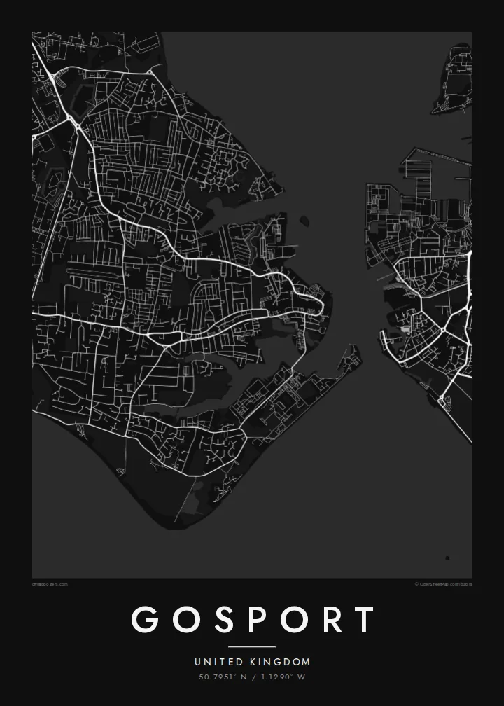
The narrow entrance to Portsmouth Harbour separates Gosport from Old Portsmouth. The short ferry crossing between them is one of the defining lines on the map.
Minimalist map poster · United Kingdom
50.7951° N / 1.1290° W
A low peninsula between Portsmouth Harbour and the Solent, edged with forts, creeks, shingle and naval yards.



One city, five moods
Ekamowa emwit style ouga bwe ouga ekamowa e dedaña ñan bwega. Style otata a kor eangan — eprint, eframe ke HD files.
 Pixel ekwan · 24 × 36″ print file
Print-sharp
Enin 100% crop eo mai print file eo elango. Poster otata — eprint, eframe ke edownload — erender iaan server bwir e 300 DPI, dedaña ñan 7,200 × 10,800 pixels, bwe lane ekekedik ekwan ebwe crisp iaan print 24 × 36″.
Ituro


The map
Gosport sits on a peninsula on the western side of Portsmouth Harbour, facing the city across a narrow stretch of water. On a map the town is framed almost entirely by sea: the harbour to the east, the Solent and Stokes Bay to the south, and tidal creeks cutting into its western edge. Much of its shoreline has long belonged to the Royal Navy.
The street pattern shows that history. The old town and ferry pontoon crowd the harbour mouth. Large institutional sites, including the former Royal Hospital Haslar and a string of Victorian forts, take up blocks that no ordinary street runs through. Beyond them, twentieth-century housing spreads west toward Fareham in looser curves and cul-de-sacs.
A Gosport map poster suits anyone who has served here, grown up here, or crossed on the Gosport Ferry more times than they can count. It also works as a companion print to Portsmouth, because the two towns share a harbour and read best side by side. The Submarine Museum on the waterfront is one of the town's best-known sights.
The narrow entrance to Portsmouth Harbour separates Gosport from Old Portsmouth. The short ferry crossing between them is one of the defining lines on the map.
The southern coast runs as a long, gentle curve of shingle facing the Isle of Wight. It gives the lower edge of the poster a clean, open line.
Victorian forts and former naval sites show up as large enclosed shapes among the terraced streets, a pattern that is typical of a garrison town.
Make it yours
Add a date, a name or a line of your own, switch style, size or orientation.
Preview ededa low-resolution im watermark. Print im HD files erender iaan 300 DPI, dedaña ñan 7,200 × 10,800 px, ededa watermark.
Why Gosport
Gosport is a place many people pass through with the navy and remember for good. A map of the peninsula, harbour and all, suits a hallway, a study or the wall of anyone whose family story includes these docks.
You can change the title, subtitle and coordinates, for example to add a ship's name, a posting or a date. Choose from Classic black & white, Noir, Paper, Blueprint or Sand. Blueprint suits the naval shoreline particularly well.
Oder poster Gosport| Print size | Resolution | Files |
|---|---|---|
| 30 × 40 cm11.8 × 15.7″ | 3,543 × 4,724 px | PNG · PDF |
| 29.7 × 42 cm (A3)11.7 × 16.5″ | 3,508 × 4,961 px | PNG · PDF |
| 42 × 59.4 cm (A2)16.5 × 23.4″ | 4,961 × 7,016 px | PNG · PDF |
| 45.7 × 61 cm18 × 24″ | 5,400 × 7,200 px | PNG · PDF |
| 50 × 70 cm19.7 × 27.6″ | 5,906 × 8,268 px | PNG · PDF |
| 61 × 91.4 cm24 × 36″ | 7,200 × 10,800 px | PNG · PDF |
For comparison, the free preview is 900 px wide, watermarked and meant for screens. The HD files have up to 8× the resolution in each direction and print cleanly at full poster size.
Emwit style iaan capña page, im dogen Printed Poster — size eo, im framme ouga tomwin — ke Digital HD Files. Checkout eaer sit step, im order page bwira eupdate iaan payment eo emej.
Eprint iaan matte paper 200 gsm, iaan size eo eo, mai 30 × 40 cm ñan 24 × 36″. Poster eprint eo emeja iaan $39, shipping ededo.
Eko. Emwit frame wood solid iaan black, white, oak natural ke wood dark. Etaña shatterproof glazing im ready ñan hang. Poster eframe emeja iaan $99, shipping ededo.
Shipping ma free ägen 60+ country. Poster ngaga eo e print ägen print partner nearest ibiema 30+ country, ae e tep ägen 3–7 business day. Ngaga kor status ae tracking ibe My Orders. Country ibiema e tep 2–5 week, ae country ngaga ibe shipping e bwaren, website e ibin oen bwa ngaga pay.
Kabun photo bwira iaan 14 aean mai delivery, im bwira ereprint ededo ke erefund.
Eko. Iaan editor page eanin, ouga change title, subtitle, im coordinates line ñan tomwin ouga koda, im emwit style im size. Order eprint, eframe im digital otata ekamowa design ouga tomwin.
Iaan $9 ouga ereub 300 DPI PNG im PDF print-ready iaan size otata eo, ededa watermark, ñan print ekamowa tomwin. Ouga aewedik? Download preview ededa watermarked kabun.
