Valley roads
The main routes run along valley bottoms, bending with the terrain rather than following a grid, so the strongest lines on the map trace the shape of the land beneath them.
Minimalist map poster · Japan
34.0262° N / 135.2528° E
A small settlement in the folded hills of western Wakayama, where roads follow valley floors between terraced slopes.




One city, five moods
Ekamowa emwit style ouga bwe ouga ekamowa e dedaña ñan bwega. Style otata a kor eangan — eprint, eframe ke HD files.
 Pixel ekwan · 24 × 36″ print file
Print-sharp
Enin 100% crop eo mai print file eo elango. Poster otata — eprint, eframe ke edownload — erender iaan server bwir e 300 DPI, dedaña ñan 7,200 × 10,800 pixels, bwe lane ekekedik ekwan ebwe crisp iaan print 24 × 36″.
Ituro


The map
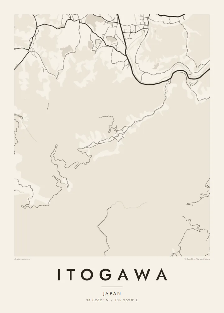
Itogawa is a small place in Wakayama Prefecture, on the western side of the Kii Peninsula. The land here is rarely flat for long: hills rise close on every side, and settlements tend to follow the narrow valleys where there is room for houses, fields and a road. On a map that produces a shape quite unlike a planned city, long and threaded rather than square.
Wakayama is best known in Japan for its citrus, and the prefecture is the country's leading producer of mikan mandarins, many of them grown on slopes facing the sea. It is also home to the Kumano pilgrimage routes and the temple settlement of Mount Kōya, both further inland and both part of a UNESCO World Heritage listing.
An Itogawa map poster captures the way people have fitted streets into terrain. Roads bend with the contours, lanes branch off into side valleys and stop, and small clusters of buildings appear wherever the ground allows. The result is an organic, almost hand-drawn pattern that feels closer to a landscape study than to a conventional city plan.
The main routes run along valley bottoms, bending with the terrain rather than following a grid, so the strongest lines on the map trace the shape of the land beneath them.
Narrow lanes climb away from the main roads toward farms and orchards on the slopes, ending in short spurs that give the edges of the map a fine, branching texture.
Large blank areas between the built-up clusters stand for forested hills and farmland, and they give the composition generous breathing room that suits a minimalist print.
Make it yours
Add a date, a name or a line of your own, switch style, size or orientation.
Preview ededa low-resolution im watermark. Print im HD files erender iaan 300 DPI, dedaña ñan 7,200 × 10,800 px, ededa watermark.
Why Itogawa
This is a map for someone with a personal link to the area, whether through family, a stay in the countryside or a trip along the Wakayama coast. Its winding, uneven lines have a calm quality that sits well in a study, bedroom or entrance hall.
The title, subtitle and coordinates can all be changed, so the print can carry a family name and a date that matters. Choose Classic black & white, Noir, Paper, Blueprint or Sand, and check a free 900 px preview before buying.
Oder poster Itogawa| Print size | Resolution | Files |
|---|---|---|
| 30 × 40 cm11.8 × 15.7″ | 3,543 × 4,724 px | PNG · PDF |
| 29.7 × 42 cm (A3)11.7 × 16.5″ | 3,508 × 4,961 px | PNG · PDF |
| 42 × 59.4 cm (A2)16.5 × 23.4″ | 4,961 × 7,016 px | PNG · PDF |
| 45.7 × 61 cm18 × 24″ | 5,400 × 7,200 px | PNG · PDF |
| 50 × 70 cm19.7 × 27.6″ | 5,906 × 8,268 px | PNG · PDF |
| 61 × 91.4 cm24 × 36″ | 7,200 × 10,800 px | PNG · PDF |
For comparison, the free preview is 900 px wide, watermarked and meant for screens. The HD files have up to 8× the resolution in each direction and print cleanly at full poster size.
Emwit style iaan capña page, im dogen Printed Poster — size eo, im framme ouga tomwin — ke Digital HD Files. Checkout eaer sit step, im order page bwira eupdate iaan payment eo emej.
Eprint iaan matte paper 200 gsm, iaan size eo eo, mai 30 × 40 cm ñan 24 × 36″. Poster eprint eo emeja iaan $39, shipping ededo.
Eko. Emwit frame wood solid iaan black, white, oak natural ke wood dark. Etaña shatterproof glazing im ready ñan hang. Poster eframe emeja iaan $99, shipping ededo.
Shipping ma free ägen 60+ country. Poster ngaga eo e print ägen print partner nearest ibiema 30+ country, ae e tep ägen 3–7 business day. Ngaga kor status ae tracking ibe My Orders. Country ibiema e tep 2–5 week, ae country ngaga ibe shipping e bwaren, website e ibin oen bwa ngaga pay.
Kabun photo bwira iaan 14 aean mai delivery, im bwira ereprint ededo ke erefund.
Eko. Iaan editor page eanin, ouga change title, subtitle, im coordinates line ñan tomwin ouga koda, im emwit style im size. Order eprint, eframe im digital otata ekamowa design ouga tomwin.
Iaan $9 ouga ereub 300 DPI PNG im PDF print-ready iaan size otata eo, ededa watermark, ñan print ekamowa tomwin. Ouga aewedik? Download preview ededa watermarked kabun.
