Euphrates riverfront
The Euphrates runs broad along the eastern side of the town, its banks lined with fields and floodplain. On the poster, the river gives the whole composition its weight and direction.
Minimalist map poster · Syria
36.8175° N / 38.0111° E
A town on the west bank of the Euphrates at the Turkish border, beside the ancient mound of Carchemish




One city, five moods
Ekamowa emwit style ouga bwe ouga ekamowa e dedaña ñan bwega. Style otata a kor eangan — eprint, eframe ke HD files.
 Pixel ekwan · 24 × 36″ print file
Print-sharp
Enin 100% crop eo mai print file eo elango. Poster otata — eprint, eframe ke edownload — erender iaan server bwir e 300 DPI, dedaña ñan 7,200 × 10,800 pixels, bwe lane ekekedik ekwan ebwe crisp iaan print 24 × 36″.
Ituro


The map
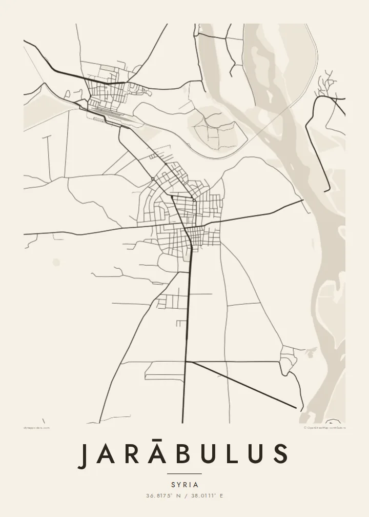
Jarābulus stands on the western bank of the Euphrates in northern Syria, directly on the border with Turkey. On the map, the river dominates: a wide band running north to south along the town's eastern edge. The border meets the water just north of the built-up area, so the town sits in a corner formed by a river and a frontier.
Just north of the town lies Carchemish, one of the major cities of the ancient Near East, whose ruins straddle the border. Before the First World War, Leonard Woolley led excavations there, and a young T. E. Lawrence was on the team. Nearby, the historic Baghdad Railway crosses the Euphrates on a long bridge, a clear straight stroke on any map of the area.
The town itself is compact. Its streets sit back from the riverbank, and roads lead south and west into the farmland of the Aleppo countryside. A Jarābulus map poster reduces all of this to a few essential lines: river, rail, border and town. It is a small place whose position has made it significant for thousands of years.
The Euphrates runs broad along the eastern side of the town, its banks lined with fields and floodplain. On the poster, the river gives the whole composition its weight and direction.
The ancient city lies just north of the modern streets, on the river near the border. It is one of the oldest urban sites in the region.
The historic Baghdad Railway crosses the Euphrates near the town on a long bridge. Its straight line across the water is one of the clearest features of the local map.
Make it yours
Add a date, a name or a line of your own, switch style, size or orientation.
Preview ededa low-resolution im watermark. Print im HD files erender iaan 300 DPI, dedaña ñan 7,200 × 10,800 px, ededa watermark.
Why Jarābulus
For people from Jarābulus, including the many who now live elsewhere, a map of the town holds on to a specific place by the river. It also suits anyone drawn to the archaeology of Carchemish or the long history of the upper Euphrates.
Add a title in your own words, a subtitle, a date and the coordinates line, and pick Classic black & white, Noir, Paper, Blueprint or Sand. The $9 digital files cover six sizes from 30×40 cm to 24×36″, each as a 300 DPI PNG and a print-ready PDF.
Oder poster Jarābulus| Print size | Resolution | Files |
|---|---|---|
| 30 × 40 cm11.8 × 15.7″ | 3,543 × 4,724 px | PNG · PDF |
| 29.7 × 42 cm (A3)11.7 × 16.5″ | 3,508 × 4,961 px | PNG · PDF |
| 42 × 59.4 cm (A2)16.5 × 23.4″ | 4,961 × 7,016 px | PNG · PDF |
| 45.7 × 61 cm18 × 24″ | 5,400 × 7,200 px | PNG · PDF |
| 50 × 70 cm19.7 × 27.6″ | 5,906 × 8,268 px | PNG · PDF |
| 61 × 91.4 cm24 × 36″ | 7,200 × 10,800 px | PNG · PDF |
For comparison, the free preview is 900 px wide, watermarked and meant for screens. The HD files have up to 8× the resolution in each direction and print cleanly at full poster size.
Emwit style iaan capña page, im dogen Printed Poster — size eo, im framme ouga tomwin — ke Digital HD Files. Checkout eaer sit step, im order page bwira eupdate iaan payment eo emej.
Eprint iaan matte paper 200 gsm, iaan size eo eo, mai 30 × 40 cm ñan 24 × 36″. Poster eprint eo emeja iaan $39, shipping ededo.
Eko. Emwit frame wood solid iaan black, white, oak natural ke wood dark. Etaña shatterproof glazing im ready ñan hang. Poster eframe emeja iaan $99, shipping ededo.
Shipping ma free ägen 60+ country. Poster ngaga eo e print ägen print partner nearest ibiema 30+ country, ae e tep ägen 3–7 business day. Ngaga kor status ae tracking ibe My Orders. Country ibiema e tep 2–5 week, ae country ngaga ibe shipping e bwaren, website e ibin oen bwa ngaga pay.
Kabun photo bwira iaan 14 aean mai delivery, im bwira ereprint ededo ke erefund.
Eko. Iaan editor page eanin, ouga change title, subtitle, im coordinates line ñan tomwin ouga koda, im emwit style im size. Order eprint, eframe im digital otata ekamowa design ouga tomwin.
Iaan $9 ouga ereub 300 DPI PNG im PDF print-ready iaan size otata eo, ededa watermark, ñan print ekamowa tomwin. Ouga aewedik? Download preview ededa watermarked kabun.
